Mitchell County, North Carolina facts for kids
Quick facts for kids
Mitchell County
|
|||
|---|---|---|---|

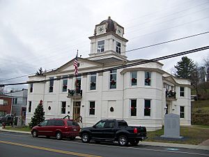
Old Mitchell County Courthouse in Bakersville
|
|||
|
|||

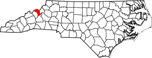
Location within the U.S. state of North Carolina
|
|||
 North Carolina's location within the U.S. |
|||
| Country | |||
| State | |||
| Founded | 1861 | ||
| Named for | Elisha Mitchell | ||
| Seat | Bakersville | ||
| Largest community | Spruce Pine | ||
| Area | |||
| • Total | 221.88 sq mi (574.7 km2) | ||
| • Land | 221.25 sq mi (573.0 km2) | ||
| • Water | 0.63 sq mi (1.6 km2) 0.28% | ||
| Population
(2020)
|
|||
| • Total | 14,903 | ||
| • Estimate
(2023)
|
14,999 | ||
| • Density | 67.36/sq mi (26.01/km2) | ||
| Time zone | UTC−5 (Eastern) | ||
| • Summer (DST) | UTC−4 (EDT) | ||
| Congressional district | 5th | ||
Mitchell County is a county in North Carolina, a state in the United States. In 2020, about 14,903 people lived here. The main town and county seat is Bakersville.
The county is home to Spruce Pine. This town is known as the "Mineral City of the World." Bakersville is called the "Gateway to Roan Mountain." Roan Mountain has the world's largest natural rhododendron garden. It also has the longest stretch of grassy bald in the Appalachian range. Many festivals happen here, like the North Carolina Mineral and Gem Festival. The North Carolina Rhododendron Festival also brings many visitors.
Contents
History of Mitchell County
Mitchell County was created in 1861. It was made from parts of five other counties. These were Burke, Caldwell, McDowell, Watauga, and Yancey counties.
The county is named after Elisha Mitchell. He was a professor at the University of North Carolina. He taught mathematics, chemistry, geology, and mineralogy. Dr. Mitchell was the first scientist to say that a peak in the Black Mountains was the highest point east of the Mississippi River. He measured its height and explored the mountain. In 1857, he sadly died after falling on a waterfall there. The mountain was later named Mount Mitchell in his honor.
In March 1993, a very strong storm hit the county. It was called "The Storm of the Century" or the "’93 Superstorm." This storm was like a hurricane. It affected many places along the East Coast of North America.
A sad event happened on May 3, 2002. A fire broke out at the Mitchell County jail in Bakersville. This was a very difficult time for the community.
Geography of Mitchell County
Mitchell County covers about 222 square miles. Most of this area is land, about 221 square miles. A small part, about 0.7 square miles, is water. It is one of the smallest counties in North Carolina. The northwest part of the county borders the state of Tennessee.
Parts of the Blue Ridge Parkway and the Appalachian Trail are in Mitchell County. Also, parts of the Pisgah National Forest and Roan Mountain State Park are in the northern areas.
Counties Nearby
- Carter County, Tennessee - to the north-northeast
- Avery County - to the northeast
- McDowell County - to the south
- Yancey County - to the southwest
- Unicoi County, Tennessee - to the north-northwest
Protected Natural Areas
- Blue Ridge Parkway (a part of it)
- Pisgah National Forest (a part of it)
Main Roads in Mitchell County
 US 19E
 NC 80
NC 80 NC 197
 NC 226
 NC 226A
 NC 261
People of Mitchell County
| Historical population | |||
|---|---|---|---|
| Census | Pop. | %± | |
| 1870 | 4,705 | — | |
| 1880 | 9,435 | 100.5% | |
| 1890 | 12,807 | 35.7% | |
| 1900 | 15,221 | 18.8% | |
| 1910 | 17,245 | 13.3% | |
| 1920 | 11,278 | −34.6% | |
| 1930 | 13,962 | 23.8% | |
| 1940 | 15,980 | 14.5% | |
| 1950 | 15,143 | −5.2% | |
| 1960 | 13,906 | −8.2% | |
| 1970 | 13,447 | −3.3% | |
| 1980 | 14,428 | 7.3% | |
| 1990 | 14,433 | 0.0% | |
| 2000 | 15,687 | 8.7% | |
| 2010 | 15,579 | −0.7% | |
| 2020 | 14,903 | −4.3% | |
| 2023 (est.) | 14,999 | −3.7% | |
| U.S. Decennial Census 1790–1960 1900–1990 1990–2000 2010 2020 |
|||
The U.S. Census Bureau collects information about people living in the county. Here is a look at the different groups of people in Mitchell County based on the 2020 census:
| Race | Number | Percentage |
|---|---|---|
| White (non-Hispanic) | 13,514 | 90.68% |
| Black or African American (non-Hispanic) | 50 | 0.34% |
| Native American | 30 | 0.2% |
| Asian | 52 | 0.35% |
| Pacific Islander | 1 | 0.01% |
| Other/Mixed | 555 | 3.72% |
| Hispanic or Latino | 701 | 4.7% |
In 2020, there were 14,903 people living in Mitchell County. There were 6,344 households and 4,031 families.
Family Backgrounds
In 2015, people in Mitchell County reported their family backgrounds. The largest groups were:
| Largest ancestries (2015) | Percent |
|---|---|
| American | 17.3% |
| English | 14.7% |
| German | 12.2% |
| Irish | 11.9% |
| Scots-Irish | 9.8% |
| Scottish | 5.0% |
| French (except Basque) | 2.3% |
| Italian | 1.9% |
| Swedish | 1.6% |
| Dutch | 1.5% |
Economy of Mitchell County
The Mitchell County Economic Development Commission (EDC) works to help businesses. It has nine members from different areas like business and education. Their main goal is to help new businesses start and existing businesses grow in Mitchell County.
Here are the top 10 largest employers in the county:
- Mitchell County Board of Education
- Sibelco North America, Inc.
- Blue Ridge Medical Center, Lllp.
- Walmart Associates, Inc.
- Mayland Community College
- Mitchell County Government
- Hospice of the Blue Ridge
- Ingles Markets, Inc.
- Bombardier Motor Corp of America (BRP)
- The Quartz Corp USA
Education in Mitchell County
Mitchell High School is a four-year high school for grades 9-12. It was built in 1978 and is in the community of Ledger.
Spruce Pine has three schools:
- Greenlee Primary (Kindergarten to 2nd grade)
- Deyton Elementary (3rd to 5th grade)
- Harris Middle (6th to 8th grade)
Bakersville has two schools:
- Gouge Primary (Kindergarten to 4th grade)
- Bowman Middle (5th to 8th grade)
Mayland Community College is also in Mitchell County. It was started in 1971. The college offers about 35 programs. These programs provide job training and ways to transfer to a four-year college.
Penland School of Crafts is an art school in the Penland Community. It teaches students how to create things using different materials. These include books, paper, clay, glass, metal, and textiles. The school started in the early 1920s. It is the largest and oldest professional crafts school in the United States.
Media in Mitchell County
The county has a weekly newspaper called The Mitchell News-Journal. It is printed by Community Newspapers, Inc. There is also a radio station, WTOE, at 1470 kHz on the AM dial. It covers local news for the area.
Communities in Mitchell County
Towns in Mitchell County
- Bakersville (this is the county seat)
- Spruce Pine
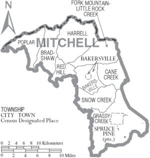
Townships in Mitchell County
- Bakersville
- Bradshaw
- Cane Creek
- Fork Mountain-Little Rock Creek
- Grassy Creek
- Harrell
- Poplar
- Red Hill
- Snow Creek
- Spruce Pine
Unincorporated Communities in Mitchell County
- Buladean
- Clarrissa
- Estatoe
- Kona
- Ledger
- Little Switzerland
- Loafers Glory
- Penland
- Poplar
- Red Hill
See also
 In Spanish: Condado de Mitchell (Carolina del Norte) para niños
 | James Van Der Zee |
 | Alma Thomas |
 | Ellis Wilson |
 | Margaret Taylor-Burroughs |


