Unicoi County, Tennessee facts for kids
Quick facts for kids
Unicoi County
|
|||
|---|---|---|---|

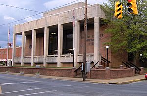
Unicoi County Courthouse in Erwin
|
|||
|
|||

Location within the U.S. state of Tennessee
|
|||
 Tennessee's location within the U.S. |
|||
| Country | |||
| State | |||
| Founded | March 23, 1875 | ||
| Named for | Cherokee word for "fog-draped" or "hazy" | ||
| Seat | Erwin | ||
| Largest town | Erwin | ||
| Area | |||
| • Total | 186 sq mi (480 km2) | ||
| • Land | 186 sq mi (480 km2) | ||
| • Water | 0.3 sq mi (0.8 km2) 0.2%% | ||
| Population
(2020)
|
|||
| • Total | 17,928 |
||
| • Density | 98/sq mi (38/km2) | ||
| Time zone | UTC−5 (Eastern) | ||
| • Summer (DST) | UTC−4 (EDT) | ||
| Congressional district | 1st | ||
Unicoi County (/ˈjuːnɪˌkɔɪ/) is a county in the state of Tennessee. In 2020, about 17,928 people lived there. The main town and county seat is Erwin.
The name Unicoi comes from a Cherokee word. It means "white," "hazy," or "fog-draped." This name describes the mist often seen in the mountains of this area. Unicoi County is part of the larger "Tri-Cities" region. This area includes Johnson City, Kingsport, and Bristol.
Contents
History of Unicoi County
Unicoi County was formed in 1875. It was made from parts of Washington and Carter counties. However, people had started settling here over a hundred years earlier. For a long time, the county was mostly farms. This changed when railroads arrived in the 1880s.
Southern Potteries and Blue Ridge China
In the 1910s, a company called the Clinchfield Railroad started a pottery factory in Erwin. This factory later became "Southern Potteries." They made popular dishes called Blue Ridge China. These dishes were special because they had hand-painted designs. The company closed in the 1950s. But Blue Ridge dishes are still popular with people who collect old items.
How to Say Unicoi
You can hear the name spoken here: Hear it spoken. This recording is from the Unicoi County Mayor Greg Lynch in 2010.
Geography of Unicoi County

Unicoi County covers about 186 square miles. Most of this area is land. Only a tiny part, about 0.3 square miles, is water. This makes it the fifth-smallest county in Tennessee.
The Nolichucky River flows into Unicoi County from North Carolina. This river is the main waterway in the county.
Mountains and Trails
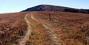
Unicoi County is entirely within the Blue Ridge Mountains. These mountains include the Bald Mountains and the Unaka Range. Big Bald is the highest mountain in the Balds. It is also the highest point in Unicoi County, at 5,516 feet (1,681 meters) tall.
The famous Appalachian Trail crosses Big Bald. The top of the mountain is a "grassy bald." This means it's a wide, open area with grass. From here, you can see amazing views of the mountains all around.
Neighboring Counties
- Washington County (north)
- Carter County (northeast)
- Mitchell County, North Carolina (east)
- Yancey County, North Carolina (south)
- Madison County, North Carolina (southwest)
- Greene County (west)
Protected Natural Areas
Unicoi County has parts of important protected areas:
- Appalachian Trail
- Cherokee National Forest
It also has a state park:
Unicoi County Population
| Historical population | |||
|---|---|---|---|
| Census | Pop. | %± | |
| 1880 | 3,645 | — | |
| 1890 | 4,619 | 26.7% | |
| 1900 | 5,851 | 26.7% | |
| 1910 | 7,201 | 23.1% | |
| 1920 | 10,120 | 40.5% | |
| 1930 | 12,678 | 25.3% | |
| 1940 | 14,128 | 11.4% | |
| 1950 | 15,886 | 12.4% | |
| 1960 | 15,082 | −5.1% | |
| 1970 | 15,254 | 1.1% | |
| 1980 | 16,362 | 7.3% | |
| 1990 | 16,549 | 1.1% | |
| 2000 | 17,667 | 6.8% | |
| 2010 | 18,313 | 3.7% | |
| 2020 | 17,928 | −2.1% | |
| U.S. Decennial Census 1790-1960 1900-1990 1990-2000 2010-2014 |
|||
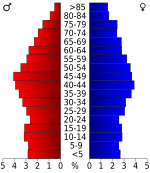
The 2020 United States census counted 17,928 people living in Unicoi County. There were 7,658 households and 4,953 families.
Population Makeup in 2020
| Group | Number | Percentage |
|---|---|---|
| White (not Hispanic) | 16,175 | 90.22% |
| Black or African American (not Hispanic) | 44 | 0.25% |
| Native American | 38 | 0.21% |
| Asian | 37 | 0.21% |
| Other/Mixed | 527 | 2.94% |
| Hispanic or Latino | 1,107 | 6.17% |
Towns and Communities
Unicoi County has a few towns and smaller communities.
Main Towns
Census-Designated Place
- Banner Hill (This is a special area defined for census data.)
Smaller Communities
- Bumpas Cove (partially in the county)
- Flag Pond
- Limestone Cove
Education in Unicoi County
All students in Unicoi County attend schools in the Unicoi County School District.
See also
 In Spanish: Condado de Unicoi para niños
 | John T. Biggers |
 | Thomas Blackshear |
 | Mark Bradford |
 | Beverly Buchanan |


