Madison County, North Carolina facts for kids
Quick facts for kids
Madison County
|
|||
|---|---|---|---|

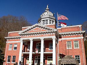
Madison County Courthouse in Marshall
|
|||
|
|||

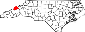
Location within the U.S. state of North Carolina
|
|||
 North Carolina's location within the U.S. |
|||
| Country | |||
| State | |||
| Founded | 1851 | ||
| Named for | James Madison | ||
| Seat | Marshall | ||
| Largest municipality | Mars Hill | ||
| Area | |||
| • Total | 451.49 sq mi (1,169.4 km2) | ||
| • Land | 449.62 sq mi (1,164.5 km2) | ||
| • Water | 1.87 sq mi (4.8 km2) 0.41% | ||
| Population
(2020)
|
|||
| • Total | 21,193 | ||
| • Estimate
(2023)
|
22,071 |
||
| • Density | 46.9401/sq mi (18.1237/km2) | ||
| Time zone | UTC−5 (Eastern) | ||
| • Summer (DST) | UTC−4 (EDT) | ||
| Congressional district | 11th | ||

Madison County is a county located in the western part of North Carolina, a state in the United States. In 2020, about 21,193 people lived here. The main town and county seat (where the county government is) is Marshall. Madison County is also part of the larger Asheville area.
Contents
History of Madison County
Madison County was created in 1851. It was formed from parts of two nearby counties: Buncombe County and Yancey County. The county was named after James Madison, who was the fourth president of the United States from 1809 to 1817.
There is a special community called Long Ridge near Mars Hill. This community has a long history as an African American settlement. It is also home to one of the last remaining Rosenwald Schools in Western North Carolina. Rosenwald Schools were special schools built for African American children in the early 1900s.
Geography and Nature
Madison County covers about 451 square miles. Most of this area, about 449 square miles, is land. Only a small part, less than 2 square miles, is water.
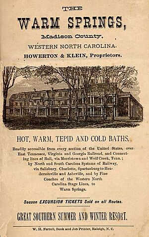
The county is located deep within the Appalachian Mountains in western North Carolina. This means much of the land is rugged and covered with thick forests. It is also not very crowded. The northern border of Madison County touches the state of Tennessee. The biggest river in the county is the French Broad River. This river flows north through the county, passing by Marshall and then the resort town of Hot Springs.
Protected Natural Areas
Parts of Madison County are protected to preserve nature. These areas include:
- Pisgah National Forest (a large national forest)
State and Local Protected Lands
There are also state and local areas set aside for wildlife and nature:
- Harmon Den Wildlife Management Area (part)
- Pisgah National Forest Game Land (part)
- Sandy Mush Game Land (part)
Major Rivers and Creeks
Important water bodies in Madison County include:
- Big Laurel Creek
- French Broad River
- Gabriel Creek
- Ivy Creek
- Little Creek
- Little Laurel Creek
- Simmons Creek
- Whiteoak Creek
Neighboring Counties
Madison County shares borders with several other counties:
- Greene County, Tennessee – to the north
- Unicoi County, Tennessee – to the northeast
- Yancey County – to the east
- Buncombe County – to the south
- Haywood County – to the southwest
- Cocke County, Tennessee – to the northwest
Main Roads and Highways
Many important roads run through Madison County, connecting it to other areas:
 I-26
I-26 US 19
US 19 US 23
US 23 US 23A
 US 25
US 25
 US 25 Bus.
 US 70
US 70
 US 70 Bus.
 NC 63
NC 63 NC 208
 NC 209
 NC 212
 NC 213
 NC 251
Population Changes Over Time
| Historical population | |||
|---|---|---|---|
| Census | Pop. | %± | |
| 1860 | 5,908 | — | |
| 1870 | 8,192 | 38.7% | |
| 1880 | 12,810 | 56.4% | |
| 1890 | 17,805 | 39.0% | |
| 1900 | 20,644 | 15.9% | |
| 1910 | 20,132 | −2.5% | |
| 1920 | 20,083 | −0.2% | |
| 1930 | 20,306 | 1.1% | |
| 1940 | 22,522 | 10.9% | |
| 1950 | 20,522 | −8.9% | |
| 1960 | 17,217 | −16.1% | |
| 1970 | 16,003 | −7.1% | |
| 1980 | 16,827 | 5.1% | |
| 1990 | 16,953 | 0.7% | |
| 2000 | 19,635 | 15.8% | |
| 2010 | 20,764 | 5.7% | |
| 2020 | 21,193 | 2.1% | |
| 2023 (est.) | 22,071 | 6.3% | |
| U.S. Decennial Census 1790–1960 1900–1990 1990–2000 2010 2020 |
|||
The population of Madison County has changed over the years. In 1860, there were about 5,908 people. The population grew steadily until the 1940s, reaching over 22,000. After that, it saw a decrease for a few decades before starting to grow again. By 2020, the population was 21,193 people.
2020 Census Information
According to the 2020 census, there were 21,193 people living in Madison County. These people lived in 8,403 households, which are groups of people living together. There were also 5,456 families. Most of the people in Madison County identified as White (non-Hispanic), making up about 90.75% of the population.
Education in Madison County
Madison County has a public school system for its students. It includes one early college high school, where students can earn college credits while still in high school. There is also one traditional high school, Madison High School, located in Marshall.
The county also has one middle school, Madison Middle School. For younger students, there are three elementary schools: Brush Creek Elementary, Hot Springs Elementary, and Mars Hill Elementary. Brush Creek Elementary was formed when Marshall Elementary and Walnut Elementary joined together after Walnut Elementary had a fire in 1998.
Madison County is also home to Mars Hill University. This is a private, four-year university where both male and female students attend. It focuses on liberal-arts education. Mars Hill University was founded in 1856, making it the oldest college or university in western North Carolina. Students at the university can choose from 34 different main subjects to study. They can earn various degrees, including Bachelor of Arts, Bachelor of Science, and Master of Education.
Local Culture and Music
Historically, Madison County was an important place for old-time folk music. This type of music often tells stories and has roots in traditional American and Appalachian culture. For example, the famous folk song Rain and Snow is believed to have started here in the late 1800s.
Communities in Madison County
Towns in the County
Madison County has three main towns:
- Hot Springs
- Mars Hill (which is the largest town)
- Marshall (which is the county seat)
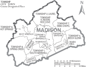
County Townships
The county is divided into twelve areas called townships. These townships have both numbers and names:
- Township 1, North Marshall
- Township 1, South Marshall
- Township 2, Laurel
- Township 3 Mars Hill
- Township 4, Beech Glenn
- Township 5, Walnut
- Township 6, Hot Springs
- Township 7, Ebbs Chapel
- Township 8, Spring Creek
- Township 9, Sandy Mush
- Township 10, Grapevine
- Township 11, Revere Rice Cove
Smaller Communities
There are also several smaller, unincorporated communities in Madison County. These are places that are not officially organized as towns:
Notable People from Madison County
- Claude DeBruhl, who served in the North Carolina House of Representatives.
See also
 In Spanish: Condado de Madison (Carolina del Norte) para niños
 | Jackie Robinson |
 | Jack Johnson |
 | Althea Gibson |
 | Arthur Ashe |
 | Muhammad Ali |


