Cocke County, Tennessee facts for kids
Quick facts for kids
Cocke County
|
||
|---|---|---|

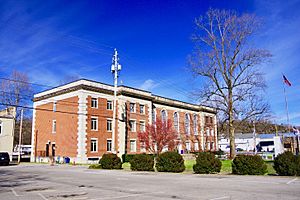
Cocke County Courthouse in Newport
|
||
|
||

Location within the U.S. state of Tennessee
|
||
 Tennessee's location within the U.S. |
||
| Country | ||
| State | ||
| Founded | October 9, 1797 | |
| Named for | William Cocke | |
| Seat | Newport | |
| Largest city | Newport | |
| Area | ||
| • Total | 443 sq mi (1,150 km2) | |
| • Land | 435 sq mi (1,130 km2) | |
| • Water | 8.6 sq mi (22 km2) 1.9%% | |
| Population
(2020)
|
||
| • Total | 35,999 |
|
| • Density | 82/sq mi (32/km2) | |
| Time zone | UTC−5 (Eastern) | |
| • Summer (DST) | UTC−4 (EDT) | |
| Congressional district | 1st | |
Cocke County is a county located in the eastern part of Tennessee. It's right on the border with North Carolina. In 2020, about 35,999 people lived here. The main town and county seat is Newport. Cocke County is part of a larger area that includes Knoxville and Morristown.
Contents
History of Cocke County
Before European settlers arrived, the land that is now Cocke County was likely home to the Cherokee people. They were one of many groups of Native Americans who lived in this area for thousands of years.
The first European settlement in the county happened in 1783. People cleared land near the French Broad and Pigeon Rivers to farm. Most early settlers came from Scotland, Ireland, the Netherlands, and Germany. They traveled over the Blue Ridge Mountains from the Carolinas or through Virginia.
The county was officially created on October 9, 1797. It was formed from a part of Greene County, Tennessee. The county was named after William Cocke, who was one of Tennessee's first Senators. Living conditions were tough for early settlers because of the mountains.
During the American Civil War, many people in Cocke County supported the Union. This was common in East Tennessee, where many farmers owned their own land. On June 8, 1861, the county voted against leaving the United States. The vote was 1,185 against leaving and 518 for leaving.
Geography and Nature
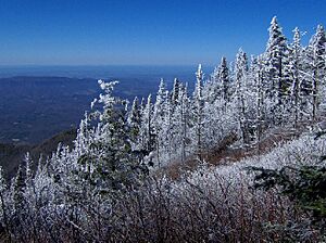
Cocke County covers about 443 square miles. Most of this is land (435 square miles), and a small part (about 8.6 square miles) is water. The southern part of the county is in the Great Smoky Mountains. This area is protected as part of the Great Smoky Mountains National Park. The northern part of the county is in the Ridge-and-Valley Appalachians.
The highest point in Cocke County is Old Black. It's about 6,370 feet tall and is located in the Smokies, on the border with North Carolina. Another big mountain is English Mountain, which is about 3,629 feet high. It stands out in the western part of the county.
The French Broad River flows through the northern part of Cocke County. It also forms part of the border with Jefferson County. A section of this river is part of Douglas Lake. This lake is an artificial reservoir, meaning it was created by a dam. The Pigeon River also flows through the county. It joins the French Broad River north of Newport.
Neighboring Counties
- Hamblen County (north)
- Greene County (northeast)
- Madison County, North Carolina (east)
- Haywood County, North Carolina (south)
- Sevier County (southwest)
- Jefferson County (northwest)
Protected Natural Areas
Cocke County has parts of several important protected areas:
- Appalachian Trail
- Cherokee National Forest
- Foothills Parkway
- Great Smoky Mountains National Park
It also has state-protected areas:
- Rankin Wildlife Management Area
- Martha Sundquist State Forest
Main Roads
 I-40
I-40 US 70
US 70 US 25
US 25 US 25E
 US 25W
 US 321
 US 411
 SR 32
SR 32
 SR 73
SR 73
Population Information
| Historical population | |||
|---|---|---|---|
| Census | Pop. | %± | |
| 1810 | 5,154 | — | |
| 1820 | 4,892 | −5.1% | |
| 1830 | 6,017 | 23.0% | |
| 1840 | 6,992 | 16.2% | |
| 1850 | 8,300 | 18.7% | |
| 1860 | 10,408 | 25.4% | |
| 1870 | 12,458 | 19.7% | |
| 1880 | 14,808 | 18.9% | |
| 1890 | 16,523 | 11.6% | |
| 1900 | 19,153 | 15.9% | |
| 1910 | 19,399 | 1.3% | |
| 1920 | 20,782 | 7.1% | |
| 1930 | 21,775 | 4.8% | |
| 1940 | 24,083 | 10.6% | |
| 1950 | 22,991 | −4.5% | |
| 1960 | 23,390 | 1.7% | |
| 1970 | 25,283 | 8.1% | |
| 1980 | 28,792 | 13.9% | |
| 1990 | 29,141 | 1.2% | |
| 2000 | 33,565 | 15.2% | |
| 2010 | 35,662 | 6.2% | |
| 2020 | 35,999 | 0.9% | |
| U.S. Decennial Census 1790-1960 1900-1990 1990-2000 2010-2014 |
|||
The U.S. Census helps us understand how many people live in an area and what groups they belong to. As of the 2020 United States census, Cocke County had 35,999 people. These people lived in 14,060 households, which are groups of people living together. There were also 9,196 families.
This table shows the different groups of people living in Cocke County in 2020:
| Race | Number | Percentage |
|---|---|---|
| White (non-Hispanic) | 32,733 | 90.93% |
| Black or African American (non-Hispanic) | 582 | 1.62% |
| Native American | 126 | 0.35% |
| Asian | 150 | 0.42% |
| Pacific Islander | 9 | 0.03% |
| Other/Mixed | 1,445 | 4.01% |
| Hispanic or Latino | 954 | 2.65% |
Towns and Communities
Cocke County has several towns and smaller communities.
City
- Newport (This is the county seat, where the main government offices are)
Town
Census-designated Place
Other Communities
Famous People from Cocke County
- Ben W. Hooper – He was the governor of Tennessee from 1911 to 1915.
- J. E. Rankin – He was a banker and also served as the mayor of Asheville, North Carolina.
- Marshall Teague – An actor who has appeared in many movies and TV shows.
See also
 In Spanish: Condado de Cocke para niños
 | James Van Der Zee |
 | Alma Thomas |
 | Ellis Wilson |
 | Margaret Taylor-Burroughs |


