
Foothills Parkway facts for kids
Quick facts for kids
[[File:|x70px|alt= marker]] |
|
|---|---|
| Lua error in Module:Infobox_road/map at line 15: attempt to index field 'wikibase' (a nil value). | |
| Route information | |
| Maintained by NPS | |
| Length | 38.6 mi (62.1 km) |
| Existed | February 22, 1944–present |
| Western segment | |
| Length | 33.0 mi (53.1 km) |
| South end | |
| North end | |
| Eastern segment | |
| Length | 5.6 mi (9.0 km) |
| South end | |
| North end | |
| Foothills Parkway Spur | |
| Length | 4.3 mi (6.9 km) |
| South end | |
| North end | |
| Location | |
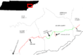
| Counties: | Blount, Sevier, Cocke |
| Highway system | |
| Tennessee State Routes Interstate • US |
|
The Foothills Parkway is a special road called a national parkway. It runs through the low mountains, or foothills, north of the Great Smoky Mountains in East Tennessee. This area is in the southeastern part of the United States. The parkway is planned to be 72.1 miles (114 km) long. It will connect U.S. Route 129 in the west to Interstate 40 in the east.
Parts of the parkway go through Blount, Sevier, and Cocke counties. Many sections cross high ridges that run next to the Great Smoky Mountains National Park. These spots give amazing, clear views of the Great Smokies to the south. You can also see the Tennessee Valley to the north.
The Foothills Parkway is Tennessee's oldest unfinished road project. It has faced money problems since the U.S. Congress approved it in 1944. As of 2018, just over half of the parkway is open for cars. However, the land needed for the entire road has been bought.
On November 8, 2018, sections 8E and 8F, including the famous "Missing Link," were finished. They opened to the public on November 10, 2018. This added 16.1 miles of completed road. Before this, the longest open part was 16.9 miles (27.2 km) long. It went along Chilhowee Mountain in Blount County. This section connected U.S. 129 near Chilhowee Lake to U.S. 321 in Walland. Another open part is 5.6 miles (9.0 km) long. It crosses Green Mountain in Cocke County. This section connects U.S. 321 in Cosby to I-40 in the Pigeon River valley.
The Gatlinburg Bypass is also part of the parkway. It goes around Gatlinburg and connects to the Great Smoky Mountains Parkway. The Great Smoky Mountains Parkway (U.S. 441) from Gatlinburg to Pigeon Forge is also managed by the National Park Service. It links the bypass to where future sections of the Foothills Parkway will be built.
The National Park Service manages these parkways as part of the Great Smoky Mountains National Park. They are not a separate park system unit. The Federal Highway Administration (FHWA) helps with road construction and repairs.
Contents
Exploring the Foothills of the Great Smoky Mountains


The foothills of the Great Smokies are a series of low mountains and hills. They lie between the Great Smoky Mountains National Park to the south and the flat areas of the Tennessee River and French Broad River valleys to the north. The most important foothills are long, narrow ridges. They run parallel to the main Smoky Mountains, like a wall around a castle.
Even though the foothills are not very high, many ridges stand out because they are separate from the main Smokies. English Mountain is one of the highest foothills at 3,629 feet (1,106 m). It is the fifth most prominent mountain in Tennessee. It can be seen clearly from Interstate 40 between Sevierville and Newport. Chilhowee Mountain is another major feature. Its eastern side, called "The Three Sisters," is visible from almost anywhere in Maryville.
The rocks in the foothills are mostly sandstone, siltstone, and shale. They are about 300 to 500 million years old. This means the foothills' rocks are much younger than the billion-year-old rocks that form the highest parts of the Great Smokies.
Some of the most well-known foothills include:

Chilhowee Mountain is a narrow ridge between the Little Tennessee River and the Little Pigeon River valley. It is 35 miles (56 km) long but only 3 or 4 miles (4.8 or 6.4 km) wide. The Little River cuts through the middle of the mountain near Walland. The highest point on the western part is 2,650 feet (807 m) at a spot called Look Rock.
Bates Mountain is a low, bulky ridge between Miller Cove and Tuckaleechee Cove. Its highest point is just over 1,700 feet (518 m). Building the parkway here was hard because of a rocky gorge cut by Carr Creek.
Cove Mountain is a large ridge near Wears Valley, Gatlinburg, and Pigeon Forge. Part of the national park boundary runs along its top. The mountain reaches 4,077 feet (1,243 m) at its peak.
Webb Mountain is a long, narrow ridge about 10 miles (16 km) long. It dominates the view north of U.S. 321 between Pittman Center and Cosby. Its highest point is 3,100 feet (945 m) above sea level.
Green Mountain is a small mountain between Cosby and the Pigeon River valley. Its highest point is 2,785 feet (849 m) above sea level.
English Mountain is the highest of the Foothills at 3,629 feet (1,106 m). It stretches for nearly 15 miles (24 km) and runs next to Douglas Lake. Hall Top (Stone Mountain) rises above the Pigeon River valley. The parkway does not cross English Mountain or Hall Top.
The History of the Parkway Project

Tourists started visiting the Great Smokies foothills in the mid-1800s. Many came for the area's natural springs, which people thought had healing powers. Hotels quickly appeared, becoming popular summer spots for wealthy people from Knoxville. Some famous resorts included Montvale Springs and Alleghany Springs.
Before the Civil War, author Sidney Lanier spent summers at Montvale Springs. The Chilhowee Mountain area greatly influenced his first novel, Tiger Lilies. In 1885, author Mary Noailles Murfree wrote about the beauty of Chilhowee Mountain.
The first plan for the Great Smoky Mountains National Park included much of the foothills. However, by the time the park opened in 1934, the boundary had moved south.
How the Parkway Idea Began

In the 1930s, Congress approved the Blue Ridge Parkway. It was decided that this parkway would not go through Tennessee. Frank Maloney, who worked for a conservation group, was disappointed. He began asking for a parkway to connect the fun areas on the Tennessee side of the Great Smokies.

In 1944, after much effort by Congressman B. Carroll Reece, Congress approved building a 71-mile (114 km) road. It would connect US-129 at Chilhowee Lake and I-40 along the Pigeon River. In 1945, Tennessee's state government allowed the Tennessee Highway Department to buy land for the road. A second law in 1947 allowed this land to be given to the National Park Service.
Even though the early steps were done, buying the land was slow. In 1956, park superintendent Edward Hummel got the Foothills Parkway project included in a special National Park Service program. This helped get early construction money. Soon after, Governor Frank G. Clement allowed the Highway Department to start buying land. Construction finally began in 1960.
The original plan for the Foothills Parkway had eight sections:
- Section 8A: Connected U.S. 321 (now part of I-40) and Cosby. It was finished in the late 1960s and is 5.6 miles (9.0 km) long.
- Section 8B: Planned to connect Cosby to Pittman Center. It is 14.1 miles (22.7 km) long.
- Section 8C: Planned to connect Pittman Center to U.S. Route 441. It is 9.6 miles (15.4 km) long.
- Section 8D: Planned to connect US-441 to Wears Valley. It is 9.8 miles (15.8 km) long.
- Section 8E: Connected Wears Valley to Carr Creek. It is 9.7 miles (15.6 km) long. A 1.6-mile (2.6 km) part of this section, called "The Missing Link," was very hard to build. It was finished in November 2018.
- Section 8F: Connected Carr Creek to Walland. It is 6.4 miles (10.3 km) long. This section was also finished in November 2018.
- Section 8G: Connected Walland to Look Rock. It is 10.0 miles (16.1 km) long. This section opened in 1966.
- Section 8H: Connected Look Rock to Chilhowee Lake. It is 6.9 miles (11.1 km) long. This section also opened in 1966.

After good progress in the 1960s, the project slowed down in the 1970s because of less money. By 1978, less than one-third of the parkway was done. Building on the sections between Walland and Wears Valley started in 1984. But it stopped because of problems like erosion and sulfuric acid spilling into streams. The road's path was changed, and construction started again in 1994. Tennessee Congressmen John Duncan, Jr. and James Quillen helped get federal money for the project for many years.
In recent years, the Foothills Parkway project has caused some debate. Some people worry it will add to traffic in the Smokies. Others believe it will help by spreading out the traffic. Also, road projects like this often get less money than other things. So, it will likely take many more decades to finish the entire parkway. For example, the Blue Ridge Parkway took over five decades to complete.
Even though there is no money set aside for the remaining sections between Wears Valley and Cosby, the National Park Service still owns the land. So, finishing them is still possible.
What You'll See on the Parkway

Like other scenic roads, the finished parts of the Foothills Parkway go along ridge tops that would otherwise have no roads. This allows for wide, open views of the areas around them.
The Chilhowee Mountain section of the parkway has been open since 1966. It has four overlooks on its north side, looking into the Tennessee Valley. It also has eight overlooks on its south side, looking into the Smokies.
The highest point on the western part of Chilhowee Mountain is 2,650 feet (808 m) at a spot called Look Rock. There is an observation tower there. It gives you a 360-degree view of Blount County and the Western Smokies. The parking area for Look Rock is just off the parkway. A half-mile trail leads to the tower.

The Rich Mountain and Cades Cove Mountain areas are directly to the east. Gregory Bald looks like a huge dome to the south-southeast. To the southwest, you can see the Yellow Creek part of the Unicoi Mountains. You also get a clear view of Chilhowee's western ridgeline.
Many of the highest mountains in the Smokies can be seen from Look Rock. Clingmans Dome and Thunderhead Mountain are visible to the southeast. Mount Le Conte is visible to the east. On a clear day, you can even see the high peaks of the Eastern Smokies. These include Mount Guyot, Mount Chapman, and Old Black.
Looking north from Look Rock, you can see most of Blount County. Parts of Loudon and Monroe counties are also visible. Knoxville's McGhee Tyson Airport looks like a long green strip to the north-northwest. As the sun sets, the lights of Knoxville start to appear to the north. The Cumberland Plateau forms much of the northern horizon.
The Foothills Parkway crosses Green Mountain diagonally. It goes along the southwest and northeast sides of the mountain. From the southwest section, Mount Cammerer and the Eastern Smokies are clearly visible. From the northeast section, English Mountain looks like a large ridge to the northwest. Hall Top rises like a peak to the east. The lights of Newport can be seen early in the morning and late in the evening.
Main Road Connections
| County | Location | Mile | Roads intersected | Notes | |
|---|---|---|---|---|---|
| Blount | Chilhowee | 0.0 | Western segment southern start | ||
| Walland | 16.9 | 27.2 | Interchange | ||
| Sevier | Wears Valley | 33.0 | 53.1 | Western segment northern end | |
| Pigeon Forge | Future connection (not funded yet) | ||||
| Pittman Center | Future connection (not funded yet) | ||||
| Cocke | Cosby | 0.0 | 0.0 | Eastern segment southern start | |
| | 5.6 | 9.0 | Eastern segment northern end; I-40, exit 443 | ||
| 1.000 mi = 1.609 km; 1.000 km = 0.621 mi | |||||
Spur Route: A Special Connection
A part of the Great Smoky Mountains Parkway (U.S. 441/321) is seen as a "spur" or side road of the unfinished Foothills Parkway. The entire route is in Sevier County.
| Location | Mile | Roads intersected | Notes | |
|---|---|---|---|---|
| Gatlinburg | 0.0 | 0.0 | Continues as Great Smoky Mountains Parkway | |
| 0.3 | 0.48 | Gatlinburg Bypass – Great Smoky Mountains National Park | No northbound exit to bypass | |
| Pigeon Forge | 4.2 | 6.8 | Foothills Parkway (unfinished sections 8C to east and 8D to west) | Future connection (not funded yet) |
| 4.3 | 6.9 | Continues as Great Smoky Mountains Parkway | ||
| 1.000 mi = 1.609 km; 1.000 km = 0.621 mi | ||||
Images for kids
-
This map shows the finished and planned unfinished sections of the Foothills Parkway, and the counties it goes through.

