Little River (Tennessee) facts for kids
Quick facts for kids Little River |
|
|---|---|
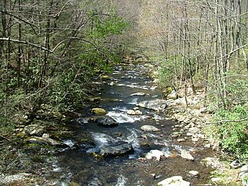
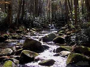
Middle Prong near the confluence of Thunderhead and Lynn Prongs
|
|
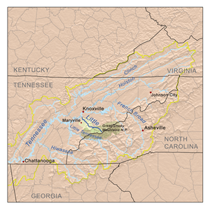
Little River watershed
|
|
| Country | United States |
| State | Tennessee |
| Physical characteristics | |
| Main source | near Collins Gap in the Great Smoky Mountains National Park 5,100 ft (1,600 m) 35°34′46″N 83°28′56″W / 35.57944°N 83.48222°W |
| River mouth | Tennessee River at Blount County/Knox County line 814 ft (248 m) 35°52′40″N 83°59′12″W / 35.87778°N 83.98667°W |
| Length | 60 mi (97 km) |
| Basin features | |
| Basin size | 380 sq mi (980 km2) |
| Tributaries |
|
The Little River is a 60-mile (97 km) long river in Tennessee. It drains an area of 380 square miles (980 km²). This area includes some of the most beautiful places in the southeastern United States. The first 18 miles (29 km) of the river are inside the Great Smoky Mountains National Park. The other 42 miles (68 km) flow out of the mountains. They pass through Blount County to join the Tennessee River at Fort Loudoun Lake in Knox County.
Contents
Exploring the Little River
From its Source to Elkmont
The Little River starts in Sevier County. This is inside the national park on the north side of Clingmans Dome. Clingmans Dome is the highest point in Tennessee. It sits right on the border between Tennessee and North Carolina.
About one mile (1.6 km) from its start, the Little River meets several smaller streams. This area is called "Three Forks." Here, the river gets much stronger. From Three Forks, a good path called the Little River Trail follows the river to Elkmont.
Elkmont was once a logging camp for the Little River Lumber Company. It was also a stop on the Little River Railroad. In the 1920s, many cabins were rented to people. These rentals lasted until 2001.
Near Elkmont, the road becomes easy to drive on. This part of the river is great for experienced kayakers and canoeists. It is also a wonderful place to fish for native brook trout.
From Elkmont to the Townsend Y
From just below Elkmont, the Little River flows next to State Route 73. This road is also known as Little River Gorge Road. It connects the two main entrances to the Great Smoky Mountains National Park in Tennessee. These entrances are in Gatlinburg and Townsend.
The river, like the road, has many twists and turns. The road was built on the old path of the Little River Railroad. This railroad was used for logging before the park was created.
Along the Little River, you can see several small waterfalls. These waterfalls flow into the river and are especially strong when it rains a lot. One waterfall, Meigs Falls, can be seen from the road. There is a parking spot to stop and look.
About halfway between Gatlinburg and Townsend, the Little River enters a flat area called Metcalf Bottoms. This area has softer rock, which allowed the flat space to form. The park has a picnic area at Metcalf Bottoms. It is a nice spot for summer picnics and wading in the water.
Just past Metcalf Bottoms, the Little River becomes faster and wilder. It cuts through Little River Gorge, a narrow valley between two mountains. One famous spot in the gorge is "The Sinks." Here, the river flows over a 10-foot (3-meter) waterfall into a big pool. Then, it seems to disappear for a short distance. It doesn't truly sink underground, but it looks like it does. Below The Sinks, you can canoe or kayak when the water is high.
The river then crosses into Blount County. It flows towards where it meets the Middle Prong of Little River. This meeting point is known as the "Townsend Y."
The Middle Prong of Little River
The Middle Prong of Little River collects water from the area between Miry Ridge and Defeat Ridge. These ridges come down from the highest parts of the Smokies. The Middle Prong forms where Lynn Camp Prong and Thunderhead Prong meet. This is near the old logging town of Tremont. Here, the river has carved a deep gorge.
From Tremont, the river flows north. It takes in Spruce Flats Branch and other smaller streams. Then, it slows down in a flat area called Walker Valley. An old railroad path follows the Middle Prong for almost all of its nine-mile (14 km) length.
Laurel Creek joins the West Prong. The West Prong then joins the Middle Prong about a mile east of the Townsend Wye. This is at the crossing of Tremont Road and Laurel Creek Road.
Only the part of the stream below the Great Smoky Mountains Institute at Tremont can be used by kayaks when the water is high. Fishing along the Middle Prong is considered excellent.
From the Townsend Wye to Walland
The Townsend 'Y' is formed where the Little River (from the east) and the Middle Prong of Little River (from the west) come together. This creates a strong river that flows north. The Townsend Y is a very popular spot for swimming in the summer. Many people also start their tubing trips here. They float about a mile down the river.
Just past the Y, the Little River leaves the Great Smoky Mountains National Park. It enters Tuckaleechee Cove and the town of Townsend. From here, the Little River can be navigated by kayak at normal water levels. Tubers usually go from the Townsend Y to the first old mill dam. This part of the river has small rapids and swimming areas. There are also large rocks in the river, like Gallaher Rock, where people can rest.
In Townsend, U.S. Highway 321 runs next to the river. Townsend is in Tuckaleechee Cove, an area known for its limestone caves. Tuckaleechee Caverns is a large cave that is a tourist attraction. It is open from about April to October. Water from the cave flows into the Little River just below Townsend.
Townsend is built along the Little River valley. Years ago, it had only small, family-run hotels and restaurants. Now, bigger hotel chains have built places to stay. You can visit the Little River Railroad and Lumber Company Museum in Townsend. There is also a greenway path that follows U.S. 321.
Many scenic swinging bridges used to cross the Little River in Townsend. Most of these have been taken down because of safety concerns. However, one bridge remains at the north end of Townsend, in an area called Kinzel Springs. Another swinging bridge is near the museum and leads to Dark Island.
The Little River continues to flow north through Miller Cove. It then reaches the small community of Walland. Walland is where the Chilhowee section of the Foothills Parkway currently ends.
From Walland to Fort Loudoun Lake
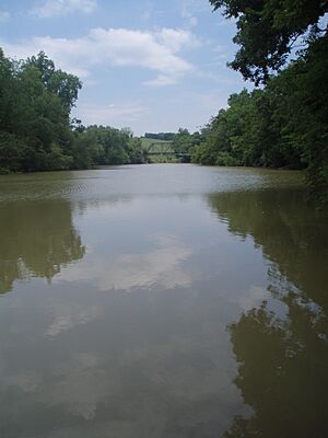
After Walland, the Little River cuts a wide path through Chilhowee Mountain. Then, it flows down into the flat areas around Maryville and Alcoa. Here, the river is not as clear as it is higher up. It looks more like a typical stream in a rural area.
From the old mill dam at Peery's Mill (north of Walland) to where the river meets Fort Loudoun Lake (about 19 miles or 31 km), you can generally canoe on the river. However, there is a dangerous low-head dam at the Rockford Manufacturing Company in Rockford. The Little River flows through farmland, under U.S. Highway 411. It also passes through the cities of Maryville and Alcoa before reaching Rockford.
About 85,000 people in these towns get their drinking water from the river. Three creeks— Pistol Creek, Short Creek, and Crooked Creek— join the Little River in this area. These three creeks are considered "impaired" (not very clean). This has led the Tennessee Department of Environment and Conservation to call the Little River "threatened."
The Little River flows into a surprisingly large bay of Fort Loudoun Lake. This lake is part of the Tennessee River. A small marina is located where the river meets the lake, along U.S. Highway 129. For its last few miles, the Little River forms the border between Blount County and Knox County.
 | Misty Copeland |
 | Raven Wilkinson |
 | Debra Austin |
 | Aesha Ash |


