Fort Loudoun Lake facts for kids
Quick facts for kids Fort Loudoun Lake |
|
|---|---|

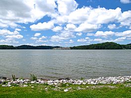
The lake in Louisville
|
|
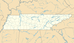
| Location | Blount / Knox / Loudon counties, Tennessee, US |
| Coordinates | 35°47′31″N 84°14′36″W / 35.79194°N 84.24333°W |
| Type | reservoir |
| Primary inflows | French Broad River, Holston River |
| Primary outflows | Tennessee River |
| Basin countries | United States |
| Surface elevation | 813 feet (248 m) |
Fort Loudoun Lake is a large, human-made lake, also called a reservoir. It's located in eastern Tennessee and is part of the upper Tennessee River. This lake stretches about 50 miles (80 km) long. It goes from Fort Loudoun Dam near Lenoir City all the way up to the city of Knoxville.
Contents
The Story Behind the Name
The lake gets its name from an old British fort. This fort was built nearby in the 1700s. It was used during the French and Indian War. The fort was named after John Campbell. He was the fourth Earl of Loudoun. At that time, he was the leader of British forces in North America.
Fun Things to Do at Fort Loudoun Lake
Fort Loudoun Lake is a very popular spot for outdoor activities. Many people enjoy bass fishing here. It's also a great place for boating and watching birds.
Birdwatching Hotspot
The area right below the dam is perfect for seeing many kinds of waterbirds. You might spot herons, cormorants, and gulls. Osprey and even bald eagles are often seen there too!
How the Lake Helps Generate Power
Fort Loudoun Lake is connected to Tellico Reservoir by a short canal. Tellico Reservoir is on the nearby Little Tennessee River. Water from Tellico is sent through this canal to Fort Loudoun. This water is then used to make electricity.
Moving Goods by Water
The canal also helps big barges move goods. These barges can travel from Tellico Reservoir to Fort Loudoun without needing a special water lock. Every year, barges carry about half a million tons of cargo through the Fort Loudoun lock. This helps move many important products.
 | Leon Lynch |
 | Milton P. Webster |
 | Ferdinand Smith |


