Louisville, Tennessee facts for kids
Quick facts for kids
Louisville
|
|||
|---|---|---|---|

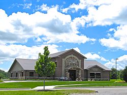
Louisville Town Hall
|
|||
|
|||

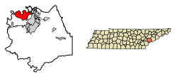
Location of Louisville in Blount County, Tennessee.
|
|||
| Country | United States | ||
| State | Tennessee | ||
| County | Blount | ||
| Government
Home Rule Charter
|
|||
| • Type | Mayor-Aldermen | ||
| Area | |||
| • Total | 17.05 sq mi (44.17 km2) | ||
| • Land | 14.92 sq mi (38.64 km2) | ||
| • Water | 2.13 sq mi (5.53 km2) | ||
| Elevation | 817 ft (249 m) | ||
| Population
(2020)
|
|||
| • Total | 4,384 | ||
| • Density | 293.81/sq mi (113.44/km2) | ||
| Time zone | UTC-5 (Eastern (EST)) | ||
| • Summer (DST) | UTC-4 (EDT) | ||
| ZIP code |
37777
|
||
| Area code(s) | 865 | ||
| FIPS code | 47-43820 | ||
| GNIS feature ID | 2404960 | ||
Louisville is a town located in Blount County, Tennessee. It is considered a suburb, meaning it's a smaller community near a larger city. In 2020, about 4,384 people lived there. Louisville is part of the larger Knoxville, Tennessee area.
Contents
A Look Back at Louisville's History
The Louisville area was first settled in the early 1800s. Its location right on the Tennessee River was very important. This helped it become a busy port for boats.
River Trade and Growth
People used flatboats (flat-bottomed boats for carrying goods) and steamboats (boats powered by steam engines) to move things. Louisville became a key place for trade. The town officially became a city in 1851.
What's in a Name?
No one is completely sure how Louisville got its name. Some people think it might be named after Louis Philippe, a French king. He visited the area in the late 1790s. In 1974, the downtown part of Louisville was recognized as a special historic district. This means it has important old buildings and history.
Exploring Louisville's Geography
Louisville is found along the northern edge of Blount County. The town's center is where two main roads meet. These are State Route 334 and State Route 333.
Roads and Rivers
State Route 334 connects Louisville to nearby towns like Alcoa and Maryville to the east. State Route 333 links Louisville to Friendsville in the west. The northern border of Louisville is formed by Fort Loudoun Lake. This lake is part of the Tennessee River.
Land and Water
Louisville covers a total area of about 17.05 square miles (44.17 square kilometers). Most of this area is land, about 14.92 square miles (38.64 square kilometers). The rest is water, which is about 2.13 square miles (5.53 square kilometers).
Who Lives in Louisville?
The number of people living in Louisville has changed over the years. In 1880, only 215 people lived there. By 2020, the population had grown to 4,384 people.
Population Changes Over Time
- 1880: 215 people
- 1890: 314 people
- 2000: 2,001 people
- 2010: 2,439 people
- 2020: 4,384 people
In 2020, there were 4,384 people living in Louisville. These people lived in 1,753 households, and 1,276 of these were families.
Schools in Louisville
Louisville has different schools for students of various ages.
Public Schools
- Middlesettlements Elementary School: This school is part of the Blount County Schools system. It teaches students from kindergarten through 5th grade.
Private Schools
- New Horizon Montessori School: This school offers classes from pre-kindergarten up to 5th grade.
- Montessori Middle School: This school is for older students, covering grades 6 through 8.
- Peninsula Village School: This school serves teenagers aged 13 to 18.
Notable People from Louisville
- Milburn White: He was a member of the Tennessee House of Representatives. This is where laws are made for the state of Tennessee.
See also
 In Spanish: Louisville (Tennessee) para niños
 | Calvin Brent |
 | Walter T. Bailey |
 | Martha Cassell Thompson |
 | Alberta Jeannette Cassell |


