
Friendsville, Tennessee facts for kids
Quick facts for kids
Friendsville
|
||
|---|---|---|

Friendsville
|
||
|
||

Location of Friendsville in Blount County, Tennessee.
|
||
| Country | United States | |
| State | Tennessee | |
| County | Blount | |
| Settled | 1790s | |
| Incorporated | 1953 | |
| Named for | Friends Church (Quakers) | |
| Area | ||
| • Total | 2.84 sq mi (7.35 km2) | |
| • Land | 2.84 sq mi (7.35 km2) | |
| • Water | 0.00 sq mi (0.00 km2) | |
| Elevation | 840 ft (260 m) | |
| Population
(2020)
|
||
| • Total | 896 | |
| • Density | 315.72/sq mi (121.89/km2) | |
| Time zone | UTC-5 (Eastern (EST)) | |
| • Summer (DST) | UTC-4 (EDT) | |
| ZIP code |
37737
|
|
| Area code(s) | 865 | |
| FIPS code | 47-28060 | |
| GNIS feature ID | 2403666 | |

Friendsville is a small city located in Blount County, Tennessee. In 2020, about 896 people lived there. It is part of the larger Knoxville, Tennessee area.
Contents
History of Friendsville
Friendsville was started in the 1790s by a group of people called Quakers. They came from North Carolina. The town still has a special building called a Friends Meetinghouse where Quakers meet.
In 1854, some Quaker leaders from Britain visited Friendsville. They were working to end slavery in the United States. During their visit, a leader named William Forster died and was buried in Friendsville.
Friendsville's Role in Ending Slavery
In the 1800s, Quakers in Blount County were very important in the movement to end slavery. Friendsville, along with nearby towns like Greenback, was a stop on the Underground Railroad. This was a secret network that helped enslaved people find freedom.
Quakers, like William J. Hackney, hid supplies in a cave near the Meetinghouse. This cave helped enslaved people and later, soldiers who wanted to join the Union army during the Civil War.
Friendsville Today
Today, Friendsville has a school called Friendsville Elementary School for students in kindergarten through fifth grade. It is part of the Blount County Schools system.
You can also find places to launch boats into Fort Loudoun Lake at Gallahar Creek and Whispering Cove. Friendsville is also home to the Blount County Campus of Pellissippi State Community College.
Geography of Friendsville
Friendsville is located in the western part of Blount County. It is found along State Route 333, also known as Miser Station Road. The city stretches from Fort Loudoun Lake in the north to U.S. Route 321 (Lamar Alexander Parkway).
The city is about 879 feet (268 meters) above sea level. The United States Census Bureau says that Friendsville covers an area of about 7.8 square kilometers (3 square miles), and all of it is land.
Population Changes in Friendsville
| Historical population | |||
|---|---|---|---|
| Census | Pop. | %± | |
| 1880 | 134 | — | |
| 1960 | 606 | — | |
| 1970 | 575 | −5.1% | |
| 1980 | 694 | 20.7% | |
| 1990 | 792 | 14.1% | |
| 2000 | 890 | 12.4% | |
| 2010 | 913 | 2.6% | |
| 2020 | 896 | −1.9% | |
| Sources: | |||
In 2000, there were 890 people living in Friendsville. There were 362 households, which are groups of people living together. Most households were married couples.
The population has changed over the years. In 1880, only 134 people lived there. By 2010, the population grew to 913 people. In 2020, the population was 896.
Images for kids
-
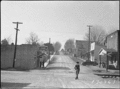
Friendsville in 1942

See also
 In Spanish: Friendsville (Tennessee) para niños
