
Knox County, Tennessee facts for kids
Quick facts for kids
Knox County
|
|||
|---|---|---|---|

|
|||
|
|||

Location within the U.S. state of Tennessee
|
|||
 Tennessee's location within the U.S. |
|||
| Country | |||
| State | |||
| Founded | June 15, 1792 | ||
| Named for | Henry Knox | ||
| Seat | Knoxville | ||
| Largest city | Knoxville | ||
| Area | |||
| • Total | 526 sq mi (1,360 km2) | ||
| • Land | 508 sq mi (1,320 km2) | ||
| • Water | 18 sq mi (50 km2) 3.5% | ||
| Population
(2020)
|
|||
| • Total | 478,971 | ||
| • Estimate
(2023)
|
500,669 |
||
| • Density | 910.6/sq mi (351.6/km2) | ||
| Congressional district | 2nd | ||


Knox County is a county in the state of Tennessee, United States. In 2020, about 478,971 people lived here. This makes it the third-largest county in Tennessee by population.
The main city and county seat is Knoxville. Knoxville is also the third-largest city in Tennessee. Knox County is part of the larger Knoxville metropolitan area. The county is in the middle of the Great Valley of East Tennessee. The Tennessee River starts here, where the Holston and French Broad rivers meet.
Contents
History of Knox County
Knox County was created on June 11, 1792. This happened after the American Revolutionary War. Governor William Blount formed it from parts of Greene and Hawkins counties. At that time, this area was called the Southwest Territory.
Knox County is one of nine counties in the United States named after Henry Knox. He was a general in the American Revolutionary War. He also became the first Secretary of War for the United States. As more people moved in, parts of Knox County were used to create other counties. These included Blount (1795), Anderson (1801), Roane (1801), and Union (1850).
In 1783, James White and Francis Alexander Ramsey explored the Upper Tennessee Valley. This area is now part of Knox County. White moved to what is now the Riverdale community in 1785. The next year, he built a fort a few miles to the west. This fort was called White's Fort. A town grew around this fort and trading post. It later became the city of Knoxville. In 1790, Governor Blount made the fort the capital of the Southwest Territory. He named the new town "Knoxville" after Henry Knox.
Governor Blount started building his house, Blount Mansion, in the early 1790s. This house is still standing in downtown Knoxville. It is one of several old buildings from the late 1700s that have been saved in the county. The Alexander McMillan House, built in the mid-1780s, is in eastern Knox County. The Alexander Bishop House (1793) and a log house built by Nicholas Gibbs (1793) are in the northern part of the county.
Campbell's Station was a fort and stagecoach stop. It was built in 1787 by Captain David Campbell. It is now in Farragut. John Sevier started a large farm called Marble Springs in the 1790s. He led attacks against the Cherokee people. The Cherokee had fought for many years to keep Americans from settling on their land.
Knox County and the Civil War

Important railroad lines ran through Knox County. This made it a key area for both Union and Confederate armies during the American Civil War. East Tennessee has many mountains, so it was not good for large farms that grew crops like cotton. Because of this, slavery was not as common here as in other parts of Tennessee. In 1860, Knox County had about 20,020 white citizens and 2,370 enslaved African Americans.
Many people in Knox County and East Tennessee supported the Union. In February 1861, 89% of people in Knox County voted to stay with the Union. On June 8, 1861, the county voted against Tennessee leaving the Union. The vote was 3,108 against leaving and 1,226 for leaving.
Before Tennessee left the Union, people who supported the Union in Knox County tried to separate from Tennessee. They wanted to stay part of the United States. Oliver Perry Temple, a lawyer from Knoxville, asked the state government in Nashville if East Tennessee could leave the state. But this attempt failed. After Tennessee voted a second time to leave the Union in 1861, Knox County joined the Confederacy.
Knox County was controlled by the Confederate army until September 3, 1863. On that day, General Ambrose Burnside and the Union army marched into Knoxville without a fight. Union troops had already taken over parts of Middle Tennessee in 1862.
Union Colonel William Harris wrote to his father about the welcome in Knoxville:
'Glory be to God, the Yankees have come! The flag's come back to Tennessee!' People were so happy as we entered Knoxville, it was amazing. They seemed wild with joy. I never knew what the Love of Liberty was before. The old flag had been hidden in mattresses and under carpets. It now flies in the wind from every pole in East Tennessee. Ladies wear it – carry it – wave it! Little children clap their hands and kiss it.
The Union army won the Knoxville Campaign, especially the Battle of Fort Sanders. After this, Knox County stayed under Union control for the rest of the Civil War.
Tennessee Marble
In the late 1800s and early 1900s, Knox County was famous for its "Tennessee marble." This is a type of limestone used to build monuments across the United States and Canada. In 1882, there were eleven marble quarries (places where stone is dug out) in Knox County. Ten years later, this number had doubled.
Important quarries in Knox County included the Bond Quarry in Concord. There was also an Evans Company quarry near Forks-of-the-River. The Ross-Republic quarries were near Island Home Park in South Knoxville. Places to finish the marble were in Lonsdale and at the Candoro Marble Works in South Knoxville.
Geography of Knox County

Knox County covers about 526 square miles (1,362 square kilometers). About 508 square miles (1,316 square kilometers) is land, and 18 square miles (47 square kilometers) is water. The county is in the Ridge-and-Valley Appalachians. This area has long, narrow ridges and valleys that run from northeast to southwest.
Some important ridges in the county are Bays Mountain, McAnnally Ridge, Beaver Ridge, Sharp's Ridge, and Copper Ridge. House Mountain is the highest point in the county. It is 2,064 feet (629 meters) tall. It is now a state natural area.
The Holston and French Broad rivers meet in the eastern part of the county. This area is called "Forks-of-the-River." Here, they form the Tennessee River. This part of the river is now Fort Loudoun Lake. This lake was made by the Fort Loudoun Dam, which is several miles downstream.
Cherokee Caverns
Cherokee Caverns is a cave located 14 miles (23 kilometers) west of Knoxville. You can reach it by Highway 62. Robert Crudgington discovered the cave in 1854. He saw fog coming out from rocks on his farm. He dug open the entrance and explored the cave. His daughter, Margaret Crudgington, opened the cave to visitors in 1929. She first called it Gentrys Cave, then Grand Caverns.
The cave has been open to the public on and off since then. It is now called Cherokee Caverns. This name refers to the Cherokee people, who lived in this area long ago. Old Native American tools found in the cave show that there was once another entrance to the cave.
Counties Nearby
- Union County (north)
- Grainger County (northeast)
- Jefferson County (east)
- Sevier County (southeast)
- Blount County (south)
- Loudon County (southwest)
- Roane County (west)
- Anderson County (northwest)
Protected Natural Areas
Knox County has several protected natural areas:
- Forks of the River Wildlife Management Area
- Fort Loudoun Wildlife Management Area
- House Mountain State Natural Area
- Marble Springs (state historic site)
- Seven Islands State Birding Park
People of Knox County
In 2020, there were 478,971 people living in Knox County. There were about 191,925 households. Most people in the county are White (about 82%). About 8.3% are Black or African American, and 2.5% are Asian. About 6% of the population is Hispanic or Latino.
Getting Around Knox County
Public Transportation
Knoxville Area Transit offers bus service within the city. McGhee Tyson Airport has many flights to cities in the Midwest and Southern United States.
Main Roads
Many major highways pass through Knox County, connecting it to other parts of Tennessee and beyond. These include:
 I-40
I-40 I-75
I-75 I-140
I-140 I-275
I-275 I-640
I-640 US 11
US 11 US 11E
 US 11W
 US 25W
 US 70 (Kingston Pike)
 US 129
 US 441
 SR 1
SR 1 SR 7
SR 7- Invalid type: TN
- Invalid type: TN
- Invalid type: TN
- Invalid type: TN
- Invalid type: TN
- Invalid type: TN
- Invalid type: TN
- Invalid type: TN / Invalid type: 131
- Invalid type: TN
- Invalid type: TN
- Invalid type: TN / Invalid type: 168
- Invalid type: TN / Invalid type: 169
- Invalid type: TN / Invalid type: 170
- Invalid type: TN / Invalid type: 331
- Invalid type: TN / Invalid type: 332
Towns and Communities
City
- Knoxville (This is the main city and county seat)
Town
Census-Designated Places (CDPs)
These are areas that are like towns but are not officially incorporated as cities.
- Halls Crossroads
- John Sevier
- Karns
- Mascot
- Powell
Unincorporated Communities
These are smaller communities that are not part of an official city or town.
- Beech Grove
- Bonny Kate
- Carter
- Concord
- Corinth
- Corryton
- Grandview
- Harbison Crossroads
- Hardin Valley
- Heiskell
- Kimberlin Heights
- King Arthur Court
- Midway
- Millertown
- New Hopewell
- Shady Grove
- Strawberry Plains (partly in another county)
- Solway
- Thorn Grove
Education in Knox County
The Knox County School District runs the public schools in the county. The Tennessee School for the Deaf is also located in the county. It is a state-run school.
Images for kids
-
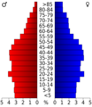
Age pyramid for Knox County

See also
 In Spanish: Condado de Knox (Tennessee) para niños
