Corryton, Tennessee facts for kids
Quick facts for kids
Corryton, Tennessee
|
|
|---|---|
| Corryton Village | |

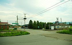
Corryton Depot near the intersection of Corryton Road and Corryton Luttrell Road
|
|
| Country | United States |
| State | Tennessee |
| County | Knox |
| Settled | 1785 |
| Founded by | John Sawyers |
| Named for | Corryton Woodbury |
| Government | |
| • Type | County Commission |
| Elevation | 1,043 ft (318 m) |
| Time zone | UTC-5 (Eastern (EST)) |
| • Summer (DST) | UTC-4 (EDT) |
| ZIP codes |
37721
|
| Area code(s) | 865 |
| FIPS code | 47093 |
| GNIS feature ID | 1281332 |
Corryton, also known as Corryton Village, is a small community in northeastern Knox County, Tennessee, United States. It is an "unincorporated area," which means it doesn't have its own city government. Instead, it's part of the larger county. Corryton is located about 15 miles northeast of Knoxville and is considered part of the Knoxville metropolitan area.
Contents
Exploring Corryton's Location
Corryton is nestled near two important mountains. One is House Mountain, which is the highest point in all of Knox County. The other is Clinch Mountain.
Community Life in Corryton
This community is home to several schools, including two elementary schools, a middle school, and a high school. There is also a public library and a community center. Many churches are in Corryton, such as Little Flat Creek Baptist Church, which was founded in 1797. This makes it the first Baptist church ever organized in Knox County. Other churches include Corryton Church and Rutherford Memorial United Methodist.
Corryton's Past: A Brief History
The area where Corryton is today was first settled a long time ago in 1785. A man named John Sawyers, who was a veteran of the Revolutionary War, moved here. He even built a small fort nearby. For many years, Corryton was mostly a farming community.
The Railroad Arrives
Things started to change in the late 1880s when the Knoxville, Cumberland Gap and Louisville Railroad was built through the area. A train station was set up to serve the community. It was first called "Floyd."
A Developer's Vision
In 1887, a person named Corryton Woodbury bought land around the train station. He wanted to turn the area into a bigger, more suburban town. However, his plan didn't quite work out. The land lots didn't sell as he hoped, and Corryton remained a mostly rural, quiet place.
A World Record Flight
On April 25, 1983, something exciting happened near Corryton. A pilot named Thomas Knauff set a FAI world record for flying a glider. A glider is an aircraft that flies without an engine, using air currents.
He flew an amazing distance of about 1,646 kilometers (or 1,023 miles). He started his flight in Pennsylvania, flew south, and took a picture of the Little Flat Creek Church in Corryton as a checkpoint. Then, he flew all the way back to Pennsylvania. His flight lasted 10 hours! Pictures from this flight were even published in National Geographic magazine. This world record stood for 20 years, until 2003. It is still a U.S. national record.
Famous People from Corryton
Many talented people have come from the Corryton area, especially from Gibbs High School.
- Kenny Chesney – a very popular country music singer-songwriter.
- Phil Leadbetter – a well-known bluegrass musician.
- Ashley Monroe – a talented singer-songwriter.
- Morgan Wallen – a popular country pop singer-songwriter.
See also
 In Spanish: Corryton para niños
 | Leon Lynch |
 | Milton P. Webster |
 | Ferdinand Smith |


