Clinch Mountain facts for kids
Quick facts for kids Clinch Mountain |
|
|---|---|
| Highest point | |
| Elevation | 4,689 ft (1,429 m) ("Beartown Mountain" summit) |
| Geography | |
| Location | Tennessee and Virginia, U.S. |
| Parent range | Appalachian Mountains, Ridge-and-valley Appalachians |
| Climbing | |
| First ascent | 1700s |
| Easiest route | US 25E/SR 32 in Grainger County, Tennessee |
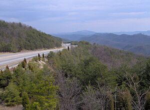
Clinch Mountain is a long mountain ridge in the U.S. states of Tennessee and Virginia. It is part of the Appalachian Mountains, specifically the ridge-and-valley section.
The mountain starts near Blaine, Tennessee, where three counties meet: Knox, Union, and Grainger. From there, it stretches northeast all the way to Garden Mountain near Burke's Garden, Virginia. Clinch Mountain acts like a natural wall. It separates the Clinch River basin to the north from the Holston River basin to the south.
Contents
Exploring Clinch Mountain's Geography
Clinch Mountain is a very long ridge, stretching about 150 miles (240 km). It generally runs from the southwest to the northeast. Because it's so big, some people call it a mountain range.
This ridge includes a smaller part called Knob Mountain. It also has four peaks that are over 4,000 feet (1,200 meters) high. These tall summits are Beartown Mountain, Flattop Mountain, Morris Knob, and Chimney Rock Peak.
How Roads Cross Clinch Mountain
For most of its length, Clinch Mountain is a solid barrier. There is only one natural gap that completely cuts through the ridge. This gap is called Moccasin Gap. It is located between Weber City and Gate City, Virginia. Big Moccasin Creek flows through this gap.
Because Moccasin Gap has no elevation change, it's perfect for roads and railways. The Norfolk Southern Railway and U.S. Highways 23-58-421 use this path. There are plans to make Moccasin Gap even wider for a new highway project. This will change how the gap looks.
Other roads that cross Clinch Mountain have to climb up and over the ridge. For example, U.S. Highway 25E in Tennessee was made into a four-lane road in the 1980s. To do this, workers had to cut a new gap into the mountain. This lowered the original gap by 200 feet (61 meters).
Clinch Mountain's Past
Clinch Mountain gets its name from the Clinch River. The river was named after an explorer from the 1700s. One of the first times the name was written down was in the journal of Dr. Thomas Walker. He wrote about "Clinch's River, from one Clinch a hunter."
Important Historical Paths
The famous Wilderness Road was a path used by pioneers. It led to the Cumberland Gap. This road crossed Clinch Mountain at Moccasin Gap. This is the same gap that Moccasin Creek flows through.
Civil War and Resorts
During the American Civil War, a peak called Signal Point was used. It was near the southern end of Clinch Mountain. Soldiers used it to send signals. The mountains also played a role in the Battle of Bean's Station.
Later, in the late 1800s, the area became famous for its mineral springs. People from all over the world visited Tate Springs in Grainger County, Tennessee. This town had a huge hotel, a golf course, and mineral baths. It even had its own train stop! Rich and famous families like the Fords, Studebakers, Mellons, Firestones, and Rockefellers stayed there. Sadly, a big fire and the Great Depression destroyed most of the resort. Only a few buildings remain today.
Music Inspired by Clinch Mountain
Clinch Mountain has inspired many folk songs. "Way Up on Clinch Mountain" is a folk song based on an old Scottish ballad. Woody Guthrie recorded his own version called "Rye Whiskey." This song is also in Carl Sandburg's book, American Songbag.
The famous Carter Family sang about the mountain in their 1928 song, "My Clinch Mountain Home." There's also a popular fiddle tune called "Clinch Mountain Backstep." It's often played in Appalachian folk music.
Roads and Tunnels Across the Mountain
Here are some of the main ways to cross Clinch Mountain, from southwest to northeast:
- Tennessee
- Joppa Mountain Road connects Joppa and Powder Springs through Powder Spring Gap.
- U.S. Route 25E (State Route 32) links Tazewell and Bean Station via Bean Gap.
- State Route 31 goes between Spruce Pine and Treadway through Flat Gap.
- State Route 66 connects Klondike and Lee Valley through Big War Gap.
- State Route 70 runs from Alumwell to Eidson through Little War Gap.
- Virginia
- The CSX Kingsport Subdivision railway connects Kermit and Speers Ferry using the Clinch Mountain Tunnel.
- U.S. Route 23/U.S. Route 58/U.S. Route 421 and the Norfolk Southern Railway Appalachia Division connect Weber City and Gate City through Moccasin Gap.
- State Route 612 links Mendota and Collinwood via Fugate Gap.
- U.S. Route 19/U.S. Route 58 Alternate connects Holston and Hansonville through Little Moccasin Gap.
- State Route 80 goes from Hayters Gap to Rockdell via Hayters Gap.
- State Route 91 connects Tannersville and Maiden Spring through an unnamed crossing.
- State Route 16 links Asberrys and Benbow through another unnamed crossing.
 | Selma Burke |
 | Pauline Powell Burns |
 | Frederick J. Brown |
 | Robert Blackburn |


