Blaine, Tennessee facts for kids
Quick facts for kids
Blaine, Tennessee
formerly Blaine's Crossroads
|
|
|---|---|

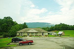
Blaine City Hall and Library
|
|
| Motto(s):
"The City With Determination"
|
|

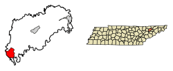
Location of Blaine in Grainger County, Tennessee.
|
|
| Country | United States |
| State | Tennessee |
| County | Grainger |
| Incorporated | 1978 |
| Named for | Robert Blaine |
| Government | |
| • Type | Mayor-council |
| Area | |
| • Total | 9.53 sq mi (24.69 km2) |
| • Land | 9.52 sq mi (24.65 km2) |
| • Water | 0.02 sq mi (0.05 km2) |
| Elevation | 1,037 ft (316 m) |
| Population
(2020)
|
|
| • Total | 2,084 |
| • Density | 219.00/sq mi (84.55/km2) |
| Time zone | UTC-5 (Eastern (EST)) |
| • Summer (DST) | UTC-4 (EDT) |
| ZIP code |
37709
|
| Area code(s) | 865 |
| FIPS code | 47-06340 |
| GNIS feature ID | 2403874 |
| U.S. Route | |
| Website | https://www.blainetn.gov/ |
Blaine, once known as Blaine's Crossroads, is a city in Grainger County, Tennessee, United States. It's like a smaller town right next to the bigger city of Knoxville. Blaine is part of the larger Knoxville and Morristown city areas. In 2020, about 2,084 people lived there.
Contents
History of Blaine
Early Days as Blaine's Crossroads
Blaine was first called Blaine's Crossroads. This name came from its location where several important roads met in the early 1800s. These roads included Emory Road (now SR 61), Indian Ridge Road, and the Great Indian Warpath (now U.S. Route 11W). A popular place called Shields' Station, which was a tavern and store, was built here by the 1830s.
The Civil War and Railroad Era
During the American Civil War, Blaine's Crossroads was a place where Confederate soldiers retreated after a battle. Union soldiers then set up a strong defense here. This stopped the Confederates from taking over Knoxville.
Later, in the late 1800s and early 1900s, Blaine became a stop on the Knoxville and Bristol Railroad. People called this the "Peavine Railroad." This railroad connected Blaine to other towns like Morristown and Corryton. The railroad helped Blaine grow from a small road town into a busy railroad town.
How Blaine Got Its Name
Around 1890, a man named Robert Blaine from Pennsylvania opened a general store in the community. As the area grew, people decided to name the city after him.
A Famous Visitor: Hank Williams
On December 31, 1952, the famous country music singer Hank Williams was seen in Blaine. He was on his way from Knoxville to a concert in West Virginia. His car was stopped by a police officer for speeding. This was one of the last times Hank Williams was seen before he passed away.
Becoming a City and Growing
In 1978, a company wanted to build a large landfill in Blaine. To have more say in what happened in their community, the people of Blaine decided to vote and officially become a city that same year. This allowed them to make their own local decisions.
In 2007, the city received money to help develop its sewage treatment system. This project helped create jobs and attract new businesses. After the wastewater system was finished in the early 2010s, Blaine saw a big increase in new businesses and people moving there. This growth was also helped by Blaine being close to Knoxville, which made it a good place for people who work in Knoxville to live.
Geography of Blaine
Where is Blaine Located?
Blaine is in the southwest part of Grainger County. It's located where U.S. Route 11W, Tennessee State Route 61, and Indian Ridge Road all meet. The city is also near where Grainger, Knox, and Union counties come together. You can see Clinch Mountain to the north and northeast, and House Mountain to the southwest.
Nearby Cities
Blaine is about 14 miles (23 km) southwest of Rutledge, which is the county seat. It's also about 12 miles (19 km) southeast of Maynardville and 19 miles (31 km) northeast of Knoxville. You can easily get to Knoxville and Rutledge using U.S. Route 11W, and to Maynardville using TN-61.
Size of the City
The United States Census Bureau says that Blaine covers a total area of about 9.4 square miles (24.3 square kilometers). All of this area is land.
Population of Blaine
How Many People Live Here?
| Historical population | |||
|---|---|---|---|
| Census | Pop. | %± | |
| 1980 | 1,147 | — | |
| 1990 | 1,326 | 15.6% | |
| 2000 | 1,585 | 19.5% | |
| 2010 | 1,856 | 17.1% | |
| 2020 | 2,084 | 12.3% | |
| Sources: | |||
Blaine's Population in 2020
In 2020, the 2020 United States census counted 2,084 people living in Blaine. There were 815 households and 613 families in the city.
| Race | Number | Percentage |
|---|---|---|
| White (non-Hispanic) | 1,942 | 93.19% |
| Black or African American (non-Hispanic) | 20 | 0.96% |
| Native American | 2 | 0.1% |
| Asian | 7 | 0.34% |
| Pacific Islander | 1 | 0.05% |
| Other/Mixed | 69 | 3.31% |
| Hispanic or Latino | 43 | 2.06% |
Economy of Blaine
Local Businesses
Blaine has a few restaurants, stores, and professional services. The only grocery store in Blaine is a Food City supermarket, which opened in 2015.
Recent Growth
The city has seen a lot of economic growth and development, especially after a new wastewater treatment plant was built. This project helped attract more businesses and people to Blaine. Because it's close to Knoxville, many people who work in Knoxville choose to live in Blaine.
Arts and Culture in Blaine
Historic Places to Visit
Blaine and its surrounding area have several interesting historic sites:
- Lea Springs (just east of town)
- Richland
- Shields' Station
- Janeway Cabin
- Emory Road
City Services and Transportation
Utilities for Residents
- Electricity: The Knoxville Utilities Board provides electricity to Blaine and nearby areas.
- Water: The Luttrell-Blaine-Corryton Utility District (LBCUD) supplies water services to Blaine.
- Wastewater: The City of Blaine manages its own wastewater treatment system. The LBCUD helps with billing for these services.
Getting Around Blaine
The Tennessee Department of Transportation (TDOT) takes care of all the main roads and highways in Blaine. The City of Blaine Public Works Department maintains the local streets, sidewalks, and greenways within the city limits.
Main Highways
 US 11W (Rutledge Pike)
 SR 1 (runs with US 11W)
 SR 61
SR 61
Other Important Roads
- Emory Road (also known as Old SR 61)
- Indian Ridge Road
- Little Valley Road
- Old Rutledge Pike
- Richland Road
- Stoutown Road
See also
 In Spanish: Blaine (Tennessee) para niños
 | Emma Amos |
 | Edward Mitchell Bannister |
 | Larry D. Alexander |
 | Ernie Barnes |

