Union County, Tennessee facts for kids
Quick facts for kids
Union County
|
|||
|---|---|---|---|

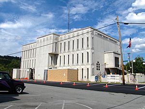
Union County Courthouse in Maynardville
|
|||
|
|||

Location within the U.S. state of Tennessee
|
|||
 Tennessee's location within the U.S. |
|||
| Country | |||
| State | |||
| Founded | January 23, 1856 | ||
| Named for | Either its creation from parts of five other counties or its support for the Union during the Civil War | ||
| Seat | Maynardville | ||
| Largest city | Maynardville | ||
| Area | |||
| • Total | 247 sq mi (640 km2) | ||
| • Land | 224 sq mi (580 km2) | ||
| • Water | 24 sq mi (60 km2) 9.5%% | ||
| Population
(2020)
|
|||
| • Total | 19,802 |
||
| • Density | 85/sq mi (33/km2) | ||
| Time zone | UTC−5 (Eastern) | ||
| • Summer (DST) | UTC−4 (EDT) | ||
| ZIP Codes |
37721, 37779, 37807, 37866, 37705
|
||
| Area code | 865 | ||
| Congressional district | 3rd | ||
Union County is a county located in the state of Tennessee. It is in the United States. In 2020, about 19,802 people lived there. The main town and government center is Maynardville. Union County is part of the larger Knoxville area.
Contents
History of Union County
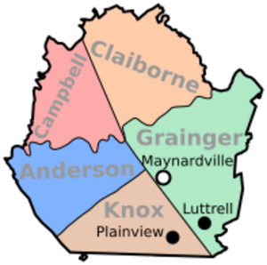
Union County was formed in 1850. It was made from parts of five nearby counties: Grainger, Claiborne, Campbell, Anderson, and Knox.
There are two main ideas about how the county got its name. It might be named "Union" because it was a "union" of parts from five different counties. Or, it could be named for its strong support of the United States during the Civil War. Many people in East Tennessee supported the Union.
The county was first approved in 1850. But because of some legal issues, it was not officially created until January 23, 1856. The county seat, or main town, was first called "Liberty." It was later renamed "Maynardville." This was to honor Horace Maynard. He was a lawyer and a congressman who helped defend the county in a court case.
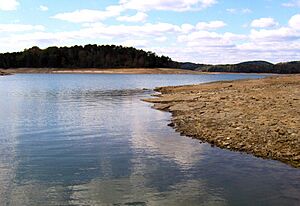
In the 1930s, the Tennessee Valley Authority (TVA) built Norris Dam. This dam created Norris Lake. A large part of Union County was covered by this new lake. Many people had to move from their homes, especially from the community of Loyston. This forced move was a big change for many families. Even though the dam was built, electricity did not come to Union County until the mid-1950s.
The TVA, with help from the National Park Service, also created Big Ridge State Park. This park was built on the shore of Norris Lake. It opened its fun areas in May 1934.
Geography of Union County
Union County covers about 247 square miles. About 224 square miles are land, and 24 square miles are water. This means about 9.5% of the county is covered by water.
The county is located in the Ridge-and-Valley Appalachians. This area has long, narrow hills (ridges) and valleys. Some important ridges in Union County are Copper Ridge, Hinds Ridge, and Lone Mountain. Part of Clinch Mountain forms the border with Grainger County.
The Clinch River is the main river in Union County. It flows through the northern part of the county. This part of the river is now Norris Lake. Big Ridge Dam is a smaller dam that creates Big Ridge Lake inside Big Ridge State Park. The "Loyston Sea" is a very wide part of Norris Lake. It is located in Union County, just north of the state park.
Neighboring Counties
- Claiborne County (north)
- Grainger County (east)
- Knox County (south)
- Anderson County (southwest)
- Campbell County (northwest)
Protected Natural Areas
- Big Ridge State Park
- Chuck Swan State Forest (part of it)
People of Union County
In 2020, there were 19,802 people living in Union County. There were 7,405 households and 5,471 families.
Economy and Jobs
The main employers in Union County offer many jobs. Here are some of the top ones from 2018:
| Employer | Employees | |
|---|---|---|
| 1 | Union County School District | 350 |
| 2 | Clayton Homes (Maynardville) | 350 |
| 3 | Union County | 150 |
| 4 | Food City | 100 |
| 5 | O-N Minerals Company | 100 |
Education in Union County
Union County has several schools:
- Big Ridge Elementary School
- Horace Maynard Middle School (used to be Horace Maynard High School until 1997)
- Luttrell Elementary School
- Maynardville Elementary School
- Paulette Elementary School
- Sharps Chapel Elementary School
- Tennessee Virtual Academy
- Union County Alternative Center, for grades 6-12
- Union County High School
Fun Places to Visit
- Roy Acuff Museum
- Big Ridge State Park
Communities in Union County
Cities
- Luttrell
- Maynardville (the county seat)
- Plainview
Small Towns and Areas (Unincorporated)
Former Town (Ghost Town)
Famous People from Union County
- Roy Acuff, an entertainer
- Chet Atkins, an entertainer
- Jake Butcher, a former banker and politician
- Kenny Chesney, an entertainer
- John Rice Irwin, a historian who started the Museum of Appalachia
- Florence Reece, who wrote the song "Which Side Are You On?", was born in Sharps Chapel in 1900.
- Carl Smith, an entertainer
See also
 In Spanish: Condado de Union (Tennessee) para niños
 | Georgia Louise Harris Brown |
 | Julian Abele |
 | Norma Merrick Sklarek |
 | William Sidney Pittman |


