Maynardville, Tennessee facts for kids
Quick facts for kids
Maynardville, Tennessee
Liberty
|
||
|---|---|---|
| City of Maynardville | ||

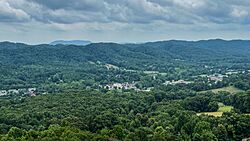
Maynardville as seen from Hinds Ridge
|
||
|
||
| Nickname(s):
The Cradle of Country Music
|
||
| Motto(s):
"A Friendly Town with an Eye on the Future.", "My Maynardville, My Home."
|
||

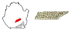
Location of Maynardville in Union County, Tennessee.
|
||
| Country | United States | |
| State | Tennessee | |
| County | Union | |
| Settled | 1850 | |
| Incorporated | 1870 | |
| Named for | Horace Maynard | |
| Government | ||
| • Type | Commission-Manager | |
| Area | ||
| • Total | 5.39 sq mi (13.97 km2) | |
| • Land | 5.39 sq mi (13.97 km2) | |
| • Water | 0.00 sq mi (0.00 km2) | |
| Elevation | 1,197 ft (365 m) | |
| Population
(2020)
|
||
| • Total | 2,456 | |
| • Density | 455.32/sq mi (175.80/km2) | |
| Time zone | UTC-5 (Eastern (EST)) | |
| • Summer (DST) | UTC-4 (EDT) | |
| ZIP code |
37807
|
|
| Area code(s) | 865 | |
| FIPS code | 47-46700 | |
| GNIS feature ID | 2405042 | |
Maynardville is a city in Union County, Tennessee, United States. It is also the county seat, which means it's where the main government offices for the county are located. The city was first called Liberty. It was renamed to honor Horace Maynard. He was a lawyer who helped create Union County.
In 2020, about 2,456 people lived in Maynardville. It is part of the larger Knoxville area.
Contents
History of Maynardville
Maynardville started as a small community in the early 1800s. It was known as Liberty back then. When Union County was formed in the 1850s, Liberty was chosen as the county seat. This was because it was close to the center of the new county. A local minister named Marcus Monroe gave the land for the courthouse.
How Maynardville Got Its Name
After the state government approved Union County, another county, Knox County, tried to stop it. They went to court because the new county would take some of their land. Supporters of Union County hired Horace Maynard, a lawyer from Knoxville. Maynard successfully defended the new county in court. Because of his help, Liberty was renamed "Maynardville" in his honor. Union County officially became a county in 1856.
Famous People from Maynardville
The famous country music singer Roy Acuff was born in Maynardville in 1903. His family had lived in Union County for a long time. Roy's grandfather, Coram Acuff, even represented Union County in the state government.
Thunder Road Story
In the early to mid-1900s, State Route 33 passed through Maynardville. This road was known as "Thunder Road." It was used for transporting certain goods in a special way. This story later inspired a 1958 movie and a song called "Thunder Road."
Modern Growth
Since the early 2000s, Maynardville has grown more like a suburb. This is because SR 33 (Maynardville Highway) was made wider. This made it quicker and easier to get to Knoxville. There are also plans to make improvements and bring new life to Maynardville.
Geography of Maynardville
Maynardville is located in the middle of Raccoon Valley. This valley is about 15 miles (24 km) long. It sits between two long, narrow ridges called Copper Ridge and Hinds Ridge. These ridges are part of the Ridge-and-Valley Appalachians mountain range. Norris Lake, which is a large body of water, is about 5 miles (8 km) north of Maynardville.
Roads and Connections
Maynardville is mainly located along State Route 33. This road connects the city to Knoxville, which is about 15 miles (24 km) to the southwest. It also connects to Tazewell, about 22 miles (35 km) to the northeast. Other important roads include:
- State Route 61: Connects Maynardville to Luttrell (8 miles/13 km south) and Blaine (13 miles/21 km south).
- State Route 144: Connects Maynardville to Plainview (8 miles/13 km southwest).
The city covers a total area of 5.4 square miles (13.97 km2). All of this area is land.
Population Information
| Historical population | |||
|---|---|---|---|
| Census | Pop. | %± | |
| 1860 | 188 | — | |
| 1870 | 155 | −17.6% | |
| 1880 | 178 | 14.8% | |
| 1890 | 144 | −19.1% | |
| 1960 | 620 | — | |
| 1970 | 702 | 13.2% | |
| 1980 | 924 | 31.6% | |
| 1990 | 1,298 | 40.5% | |
| 2000 | 1,782 | 37.3% | |
| 2010 | 2,413 | 35.4% | |
| 2020 | 2,456 | 1.8% | |
| Sources: | |||
2020 Census Details
In 2020, the 2020 United States census counted 2,456 people living in Maynardville. There were 896 households and 528 families.
Here's a look at the different groups of people living in Maynardville:
| Group | Number | Percentage |
|---|---|---|
| White | 2,247 | 91.49% |
| Black or African American | 5 | 0.2% |
| Native American | 3 | 0.12% |
| Asian | 8 | 0.33% |
| Other/Mixed | 114 | 4.64% |
| Hispanic or Latino | 79 | 3.22% |
Economy
Maynardville's economy involves several types of jobs. In 2010, the main industries for people living in Maynardville were:
- Professional services (like doctors or lawyers)
- Trade (buying and selling goods)
- Manufacturing (making things)
Many people who live in Maynardville travel outside of Union County for their jobs. In 2010, almost 62% of the city's workers commuted (traveled) to jobs in other areas.
Notable People
- Roy Acuff (1903–1992): A famous country music singer and songwriter. He was a regular performer at the Grand Ole Opry.
- Kenny Chesney: A popular country music singer.
- Carl Smith (1927–2010): Another well-known country music singer and songwriter.
See also
 In Spanish: Maynardville para niños
 | James Van Der Zee |
 | Alma Thomas |
 | Ellis Wilson |
 | Margaret Taylor-Burroughs |


