Tazewell, Tennessee facts for kids
Quick facts for kids
Tazewell, Tennessee
|
|
|---|---|
| Town of Tazewell | |

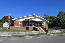
Tazewell Town Hall
|
|

Location of Tazewell in Claiborne County, Tennessee.
|
|
| Country | United States |
| State | Tennessee |
| County | Claiborne |
| Incorporated | 1801 |
| Named for | Tazewell, Virginia |
| Government | |
| • Type | Mayor-council |
| Area | |
| • Total | 4.34 sq mi (11.24 km2) |
| • Land | 4.34 sq mi (11.24 km2) |
| • Water | 0.00 sq mi (0.00 km2) |
| Elevation | 1,365 ft (416 m) |
| Population
(2020)
|
|
| • Total | 2,348 |
| • Density | 540.89/sq mi (208.85/km2) |
| Time zone | UTC-5 (Eastern (EST)) |
| • Summer (DST) | UTC-4 (EDT) |
| ZIP code |
37879
|
| Area code(s) | 423 |
| FIPS code | 47-73120 |
| GNIS feature ID | 1272257 |
Tazewell is a town in Claiborne County, Tennessee, United States. It is also the county seat, which means it is where the county's government is located. In 2020, about 2,348 people lived there.
The town got its name from Tazewell, Virginia. That town was named after Henry Tazewell, who was a U.S. senator from Virginia a long time ago.
Contents
History of Tazewell
Early Settlers and Forts
Around 1750, a doctor named Thomas Walker from Virginia shared information about a place called Cumberland Gap. This led many "long hunters" to explore the Clinch and Powell valleys. These valleys are now part of Claiborne County.
At that time, the land was used for hunting by the Cherokee and Shawano tribes. Sometimes, there were attacks from these tribes. To stay safe, hunters and early settlers built small forts and stations. One of these, called Fort Butler, was just west of where Tazewell is today.
Founding and Growth
One of the first people to settle in the Tazewell area was John Hunt (1750–1822). He was a militia captain who later helped start Huntsville, Alabama. John Hunt became the first sheriff of Claiborne County. The local government met at his house until a courthouse was built. The first courthouse was made of wood and had posts for horses outside.
Tazewell During the Civil War
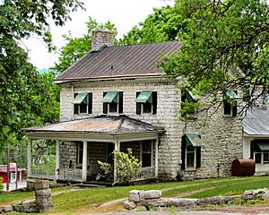
During the American Civil War in 1862, soldiers from the Confederate army took control of Tazewell. This was part of a bigger fight for the important Cumberland Gap. When the Confederate soldiers left the town in November of that year, a fire broke out. This fire destroyed a large part of Tazewell. Even today, you can still see many old buildings in the town, mostly from the Victorian era.
Notable People from Tazewell's Past
One important person from Tazewell was Boyd C. Fugate (1884-1967). He served as a State Representative.
Geography and Location
Tazewell is located at 36°27′16″N 83°34′16″W / 36.45444°N 83.57111°W. The town sits on the northern side of Wallen Ridge. This ridge is part of the Ridge and Valley Province of the Appalachian Mountains.
Big Barren Creek starts in the western part of Tazewell. It flows southwest for about 10 miles (16 km) and then empties into Norris Lake. This lake is part of the Clinch River. Streams in the eastern part of Tazewell flow into the Powell River. The Powell River is another part of the Clinch River system and flows a few miles north of Tazewell.
Tazewell is located near where two main roads meet. These are U.S. Route 25 and State Route 33. U.S. Route 25 connects Tazewell to Morristown to the southeast and Middlesboro, Kentucky to the north. State Route 33 connects Tazewell to Maynardville to the southwest.
The town covers a total area of about 4.4 square miles (11.24 square kilometers). All of this area is land.
Population and People
Tazewell has grown over the years. Here's how its population has changed:
| Historical population | |||
|---|---|---|---|
| Census | Pop. | %± | |
| 1870 | 345 | — | |
| 1880 | 342 | −0.9% | |
| 1910 | 886 | — | |
| 1920 | 424 | −52.1% | |
| 1960 | 1,264 | — | |
| 1970 | 1,860 | 47.2% | |
| 1980 | 2,090 | 12.4% | |
| 1990 | 2,150 | 2.9% | |
| 2000 | 2,165 | 0.7% | |
| 2010 | 2,218 | 2.4% | |
| 2020 | 2,348 | 5.9% | |
| Sources: | |||
In 2020, there were 2,348 people living in Tazewell. There were 1,022 households and 630 families in the town. Most of the people living in Tazewell are White. There are also smaller groups of Black or African American, Native American, Asian, Pacific Islander, and people of mixed races. Some residents are also of Hispanic or Latino background.
Education in Tazewell
Tazewell has several schools and a college campus:
- A campus of Walters State Community College
- Claiborne High School
- Soldiers Memorial Middle School
- Tazewell-New Tazewell Primary School
- AliYah Academy
- Springdale Elementary School
See also
 In Spanish: Tazewell (Tennessee) para niños
 | Lonnie Johnson |
 | Granville Woods |
 | Lewis Howard Latimer |
 | James West |


