Luttrell, Tennessee facts for kids
Quick facts for kids
Luttrell, Tennessee
|
|
|---|---|
| City of Luttrell | |

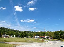
Intersection of SR 131 and SR 61 in Luttrell
|
|

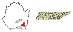
Location of Luttrell in Union County, Tennessee.
|
|
| Country | United States |
| State | Tennessee |
| County | Union |
| Incorporated | 1925 |
| Government | |
| • Type | Mayor-council |
| Area | |
| • Total | 3.93 sq mi (10.18 km2) |
| • Land | 3.93 sq mi (10.18 km2) |
| • Water | 0.00 sq mi (0.00 km2) |
| Elevation | 1,076 ft (328 m) |
| Population
(2020)
|
|
| • Total | 1,017 |
| • Density | 258.71/sq mi (99.89/km2) |
| Time zone | UTC-5 (Eastern (EST)) |
| • Summer (DST) | UTC-4 (EDT) |
| ZIP code |
37779
|
| Area code(s) | 865 |
| FIPS code | 47-44300 |
| GNIS feature ID | 1303493 |
Luttrell is a small city located in Union County, Tennessee, in the United States. In 2020, about 1,017 people lived there. Luttrell is part of the larger Knoxville area, which is a big city nearby.
Contents
History of Luttrell
Luttrell was first known as Cedar Ford. This name was used until 1890 when it was changed to Luttrell.
Early Industries in Luttrell
In the 1800s, Cedar Ford was a busy place. It had a lime kiln, which is like a big oven used to make lime. Lime is a material used in building and farming. There was also a marble quarry, where people dug up marble. Marble is a beautiful stone used for buildings and sculptures. By 1870, about 808 people lived in the area because of these jobs.
Railroad and Growth
In 1887, the Powell Valley Railroad was built through the community. This railroad helped Luttrell become an important place for shipping goods. It made it easier to send products from the area to other places. Luttrell officially became a city in 1925.
Geography of Luttrell
Luttrell covers an area of about 3.9 square miles (10.18 square kilometers). All of this area is land.
Natural Surroundings
The city is located in a valley. To the north, you can see Copper Ridge. To the south, you'll find Clinch Mountain. These ridges are part of the Ridge-and-Valley Appalachians. This is a long mountain range with many parallel ridges and valleys. Flat Creek, a small stream that flows into the Holston River, drains the area around Luttrell. The town of Plainview is located southwest of Luttrell.
Major Roads in Luttrell
Two important roads meet in Luttrell. These are Tennessee State Route 131 and Tennessee State Route 61.
- SR 131 connects Luttrell with Plainview to the southwest.
- SR 61 links Luttrell to Maynardville in the north and Blaine in the south.
Population of Luttrell
The population of Luttrell has changed over the years.
| Historical population | |||
|---|---|---|---|
| Census | Pop. | %± | |
| 1970 | 819 | — | |
| 1980 | 962 | 17.5% | |
| 1990 | 812 | −15.6% | |
| 2000 | 915 | 12.7% | |
| 2010 | 1,074 | 17.4% | |
| 2020 | 1,017 | −5.3% | |
| Sources: | |||
Recent Population Data
According to the 2020 United States census, there were 1,017 people living in Luttrell. These people lived in 366 households, and 231 of these were families. Most of the people living in Luttrell are White (about 90%). There are also smaller numbers of people from other racial backgrounds.
Famous People from Luttrell
Luttrell is proud to be the hometown of some well-known country music artists:
- Chet Atkins: A famous country music artist and a member of the Grand Ole Opry.
- Kenny Chesney: Another popular country music artist.
See also
 In Spanish: Luttrell (Tennessee) para niños
 | Audre Lorde |
 | John Berry Meachum |
 | Ferdinand Lee Barnett |

