
Big Ridge State Park facts for kids
Quick facts for kids Big Ridge State Park |
|
|---|---|

Big Ridge Lake
|
|
| Type | Tennessee State Park |
| Location | Union County, Tennessee near Maynardville |
| Area | 3,687 acres (14.92 km2) |
| Created | 1934 |
| Open | Year round |
Big Ridge State Park is a fun place in Union County, Tennessee. It's a large park, covering about 3,687 acres (14.9 km²). The park sits on the southern side of Norris Lake. This big lake was made when the Norris Dam was built on the Clinch River in 1936. A main attraction in the park is Big Ridge Lake, a smaller 45-acre (0.18 km²) lake within the park.
The park was created in the 1930s. This was part of a big project called the Norris Project. Groups like the Tennessee Valley Authority (TVA), the National Park Service, and the Civilian Conservation Corps (CCC) helped build it. Big Ridge was one of three parks made to show how fun these new lake areas could be. It opened in May 1934. Today, the Tennessee Department of Environment and Conservation takes care of the park.
Contents
Exploring the Park's Geography

Big Ridge State Park is located in the Appalachian Ridge-and-Valley range. This area has long, narrow ridges with fertile valleys in between. The park has three main ridge systems. Two of these are split by the Big Ridge Lake inlet of Norris Lake.
The northernmost ridge is called "Lone Mountain" on one side and "Big Ridge" on the other. The middle ridge is known as "Bluebird Ridge" and "Pinnacle Ridge." The southernmost ridge, "Chestnut Ridge," is not split by the lake. Dark Hollow is a narrow valley that separates the northern and central ridges. Another valley, called Blue Mud Valley or Poor Land Valley, divides the central and southern ridges.
The Clinch River flows southwest from Virginia through Tennessee. It then joins the Tennessee River. Norris Dam, built on the Clinch River, created Norris Lake. This lake is huge, covering about 34,000 acres (137.6 km²). Big Ridge State Park is located where the Clinch River and Mill Creek meet. This area is called Loyston Sea, named after a town that used to be there.
The water gap between Lone Mountain and Big Ridge became a narrow inlet when Norris Lake was formed. This inlet stretches for over a mile and then forks. Big Ridge Dam, a 50-foot (15 m) spillway dam, holds back the eastern part of this fork. This creates the 45-acre (0.18 km²) Big Ridge Lake.
Nature and Wildlife in the Park

The rocks under Big Ridge State Park are very old, formed from ocean sediments millions of years ago. You'll find limestone in the valleys and sandstone and shale on the ridges. The ridges themselves were formed 200-300 million years ago during the Appalachian orogeny. The soil here isn't great for farming.
Most of the park is covered in a second-growth hardwood forest. Common trees include oak, hickory, tuliptree, and basswood. You might also see Table mountain pine, shortleaf pine, and red cedar in drier spots.
The park is home to many animals. You might spot white-tail deer, beaver, heron, and wood duck. Sometimes, bald eagles and golden eagles visit in the winter. Big Ridge Lake has many types of fish, such as bluegill, largemouth bass, spotted bass, crappie, flathead catfish, and freshwater drum.
Park History and Development
Early Native American and Pioneer Life

Before Norris Lake was created, experts studied the area. They found almost two dozen ancient Native American sites. At one site, they found a townhouse with a clay seat and altar. This suggests it was built with small logs and grass. Another site had a large mound with a similar structure. These buildings likely date back to the Mississippian culture (around 1000-1500 AD). By the 1700s, the Cherokee people lived in this area.
In 1761, a group of long hunters explored the Clinch and Powell valleys. More settlers arrived in the 1770s and 1780s. Small forts were built to protect settlers from attacks. In the 1780s, Henry Sharp built Sharp's Station near the Clinch River. In 1794, a settler named Peter Graves was killed on Big Ridge. Sharp's Station was attacked, but the settlers fought them off. Sharp's family still owned the land when the TVA bought it in the 1930s.
The town of Loyston, now under the lake, was founded by John Loy in the early 1800s. The Loy and Sharp families made tools and household items from iron ore found along Big Ridge. By the early 1900s, Loyston was a busy trading center for the area.
The Norris Project and Park Creation

In the 1920s, people wanted to build a dam on the Clinch River. This project aimed to bring electricity and control floods in the Tennessee Valley. When the new TVA took over in 1933, they named it the Norris Project. Besides electricity and flood control, the TVA wanted to create fun recreational areas.
The Civilian Conservation Corps (CCC) Company 4495 started working on Big Ridge State Park in October 1934. The CCC built rustic cabins, a sandy beach, a lodge, and restored the old Norton Gristmill. The TVA and CCC also built Big Ridge Dam. This made sure the park had a lake even when Norris Lake's water levels changed.
Big Ridge State Park Today

Big Ridge State Park offers many things to do today. It has a campground with 50 sites and 19 rustic cabins. There's also a large group camp area and athletic fields. The sandy beach is a popular spot for swimming in the summer. You can't use private boats on Big Ridge Lake, but there's a boat launch for Norris Lake.
The park hosts fun events throughout the year. There's an Easter egg hunt before Easter. A Bluegrass music festival happens in August. In October, a medieval tournament is held by the Society for Creative Anachronism. Park rangers also lead night hikes and ghost storytelling sessions in October.
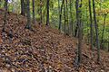
The park has over 15 miles (24 km) of hiking trails. These trails go over ridges and through valleys. The 1.5-mile (2.4 km) Lake Trail follows Big Ridge Lake. It leads to Meditation Point, a quiet spot with a bench, and the Loyston Overlook. The 1.7-mile (2.7 km) Big Valley Trail follows an old road over Pinnacle Ridge. It connects the Norton Gristmill area with Dark Hollow. The West and East Dark Hollow trails go through Dark Hollow.
The 2.6-mile (4.2 km) Indian Rock Loop goes over Big Ridge to Indian Rock. It then goes down to the Sharp's Station area. The 1.2-mile (1.9 km) Ghost House Loop passes Norton Cemetery. This area is traditionally believed to be haunted.
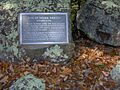
The Norton Gristmill is a key historical site in the park. It was built in 1825 and later bought by Lewis Norton. Most of the mill is a replica now, but the original mill race and millstones are still there. Other historical spots include Indian Rock, where a plaque marks the site of Peter Graves' ambush in 1794. A small monument marks the site of Sharp's Station. Norton Cemetery has the grave of Maston Hutcheson (1826–1910). Local stories say he is responsible for hauntings in the area. You can still see a few remains of his house on the Ghost House Loop Trail.
Images for kids
-
Indian Rock
-
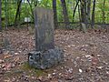
The grave of Maston Hutcheson at Norton Cemetery
-
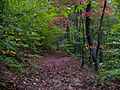
Big Valley Trail on the slopes of Pinnacle Ridge
-
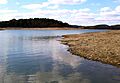
Norris Lake near the Sharp's Station site
-
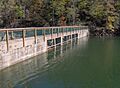
Big Ridge Dam, viewed from the Lake Trail
-
Indian Rock Trail on the slopes of Big Ridge


