
Roane County, Tennessee facts for kids
Quick facts for kids
Roane County
|
|
|---|---|

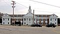
Roane County Courthouse in Kingston
|
|

Location within the U.S. state of Tennessee
|
|
 Tennessee's location within the U.S. |
|
| Country | |
| State | |
| Founded | 1801 |
| Named for | Archibald Roane |
| Seat | Kingston |
| Largest city | Kingston |
| Area | |
| • Total | 395 sq mi (1,020 km2) |
| • Land | 361 sq mi (930 km2) |
| • Water | 34 sq mi (90 km2) 8.7%% |
| Population
(2020)
|
|
| • Total | 53,404 |
| • Density | 150/sq mi (60/km2) |
| Time zone | UTC−5 (Eastern) |
| • Summer (DST) | UTC−4 (EDT) |
| Congressional district | 3rd |
Roane County is a county in the state of Tennessee, USA. A county is like a smaller region within a state. In 2020, about 53,404 people lived here. The main town, or county seat, is Kingston. Roane County is also part of the larger Knoxville area, which is a big group of cities and towns connected together.
Contents
Discovering Roane County's Past
Roane County was created in 1801. It was named after Archibald Roane, who was the second governor of Tennessee.
Early Beginnings and Fort Southwest Point
When the Southwest Territory was formed in 1790, the governor, William Blount, wanted to build the capital city near the Clinch River. However, he could not get the land from the Cherokee people. The town of Kingston, which is Roane County's main town, started from an old fort called Fort Southwest Point. This fort was built in the early 1790s to protect the frontier.
Roane County During the Civil War
During the American Civil War, many people in Roane County supported the Union, which was the northern side. On June 8, 1861, Tennessee voted on whether to leave the United States. Roane County residents voted strongly to stay in the Union.
In October 1861, a Union leader named William B. Carter planned something called the East Tennessee bridge-burning conspiracy from Kingston. Later, in December 1863, during the Knoxville Campaign, Union soldiers fought a small group of Confederate soldiers near Kingston.
Growth After the War
After the Civil War, the town of Rockwood became important for mining iron and coal. This happened because General John T. Wilder started the Roane Iron Company. Iron ore and coal were dug up from Walden Ridge and brought to Rockwood. There, the iron ore was turned into pig iron, which is a basic form of iron. This pig iron was then sent to factories in Knoxville or Chattanooga.
.jpg)
Planned Cities and World War II
In the late 1800s, people from the northern states invested money to create two new planned cities in Roane County: Cardiff and Harriman. Cardiff was meant to be a company town to support mining. Harriman was planned as a "Temperance Town," meaning it would not allow alcohol.
Both of these plans faced problems during a financial crisis in 1893. Harriman survived but did not grow as much as expected. Cardiff completely failed.
During World War II, the U.S. government built the city of Oak Ridge. This was a secret project called the Manhattan Project, which worked on creating the atomic bomb. Because of this project, two important sites, the K-25 plant and the Oak Ridge National Laboratory, are located in Roane County.
Exploring Roane County's Geography
Roane County covers about 395 square miles. Most of this is land (361 square miles), and about 34 square miles (8.7%) is water.
Rivers and Lakes
Three important rivers flow through Roane County: the Tennessee River, the Clinch River, and the Emory River. The Emory River joins the Clinch River near Kingston. Then, the Clinch River flows into the Tennessee River just a bit further downstream from Kingston. Most of the rivers in Roane County are part of Watts Bar Lake.
Land Features
Roane County is located where two different land areas meet: the Tennessee Valley and the Cumberland Plateau. You can see the edge of the Cumberland Plateau, called Walden Ridge, from many parts of the county.

Neighboring Counties
Roane County shares its borders with several other counties:
- Morgan County (to the north)
- Anderson County (to the northeast)
- Knox County (to the east)
- Loudon County (to the southeast)
- McMinn County (to the south)
- Meigs County (to the southwest)
- Rhea County (to the southwest)
- Cumberland County (to the west)
Protected Natural Areas
Roane County is home to several state-protected natural areas and wildlife management areas. These places help protect nature and animals. Some of them include:
- Campbell Bend Barrens State Natural Area
- Crowder Cemetery State Natural Area
- Kingston Refuge
- McGlothin-Largen Wildlife Management Area
- Mount Roosevelt Wildlife Management Area (part)
- Paint Rock Refuge
- Watts Bar Wildlife Management Area
People of Roane County
The population of Roane County has changed over many years. Here's a look at how it has grown:
| Historical population | |||
|---|---|---|---|
| Census | Pop. | %± | |
| 1810 | 5,581 | — | |
| 1820 | 7,895 | 41.5% | |
| 1830 | 11,341 | 43.6% | |
| 1840 | 10,948 | −3.5% | |
| 1850 | 12,185 | 11.3% | |
| 1860 | 13,583 | 11.5% | |
| 1870 | 15,622 | 15.0% | |
| 1880 | 15,237 | −2.5% | |
| 1890 | 17,418 | 14.3% | |
| 1900 | 22,738 | 30.5% | |
| 1910 | 22,860 | 0.5% | |
| 1920 | 24,624 | 7.7% | |
| 1930 | 24,477 | −0.6% | |
| 1940 | 27,795 | 13.6% | |
| 1950 | 31,665 | 13.9% | |
| 1960 | 39,133 | 23.6% | |
| 1970 | 38,831 | −0.8% | |
| 1980 | 48,425 | 24.7% | |
| 1990 | 47,227 | −2.5% | |
| 2000 | 51,910 | 9.9% | |
| 2010 | 54,181 | 4.4% | |
| 2020 | 53,404 | −1.4% | |
| U.S. Decennial Census 1790-1960 1900-1990 1990-2000 2010-2014 |
|||

Population in 2020
In 2020, there were 53,404 people living in Roane County. Most people were White (90.06%). There were also Black or African American people (2.44%), Native American people (0.3%), Asian people (0.64%), and people of other races or mixed races (4.64%). About 1.89% of the population was Hispanic or Latino.
Population in 2010
In 2010, the county had 54,181 people. The average number of people per square mile was about 150. Most people (94.4%) were White. Other groups included Black or African American (2.7%), Native American (0.3%), and Asian (0.5%). About 1.3% of the population was Hispanic or Latino.
The population was spread out, with about 20.8% of people under 18 years old and 18.6% who were 65 years or older. The average age was 44.9 years.
Roane County in Movies and Sports
Roane County has been a setting for several movies, including Boys of Summerville, That Evening Sun, and October Sky.
The famous actress Megan Fox grew up in Kingston, Roane County. She went to elementary school, took dance classes, and was on the swim team there.
The 2010 movie Get Low, which starred actors like Bill Murray and Robert Duvall, was based on a true story from Roane County. It was about a local man named Felix Breazeale, who was a hermit. He decided to have his own funeral while he was still alive! This event was so unusual that thousands of people came to attend.
Roane County has also produced many successful athletes. One recent example is Tyler Thompson from Kingston, who played Division I basketball for Tennessee Technological University.
Communities in Roane County
Roane County has several cities, one town, and many smaller communities.


Cities You Can Visit
- Harriman (a small part is in Morgan County)
- Kingston (this is the county seat, the main town)
- Oak Ridge (only part of this city is in Roane County)
- Rockwood
- Lenoir City (only part of this city is in Roane County)
One Town
- Oliver Springs (only part of this town is in Roane County)
Smaller Communities
These are smaller, unincorporated communities:
- Blair
- Cave Creek
- Cedar Grove
- Midway
- Ten Mile (partial)
- Postoak
- Paintrock
Past Communities
Some communities that used to exist in Roane County are:
Images for kids
-
Roane County Courthouse in Kingston
See also
 In Spanish: Condado de Roane (Tennessee) para niños
