Fort Southwest Point facts for kids
Quick facts for kids |
|
|
Southwest Point
|
|

Fort Southwest Point
|
|
| Location | Kingston, Tennessee |
|---|---|
| Built | 1797 |
| NRHP reference No. | 72001252 |
| Added to NRHP | 1972 |
Fort Southwest Point was an important army base in what is now Kingston, Tennessee. It was built in 1797 and had soldiers living there until 1811. The fort was a key meeting place between the Cherokee people and the United States government. It also served as a stop for early travelers moving between Knoxville and Nashville.
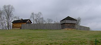
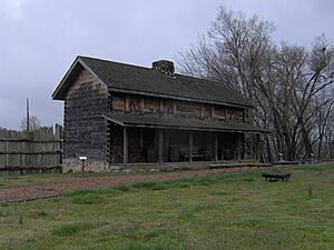
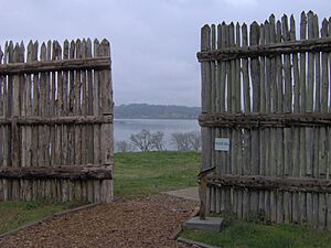
Even though old records about the fort's design were lost, archaeologists have dug up the site. Their work in the 1970s and 1980s helped figure out how the fort was laid out. Based on these findings, the City of Kingston and the Tennessee Division of Archaeology have rebuilt parts of the fort. Today, the City of Kingston manages the site.
In February 2024, Tennessee Governor Bill Lee announced that Fort Southwest Point became a Tennessee State Park.
Contents
Where is Fort Southwest Point Located?
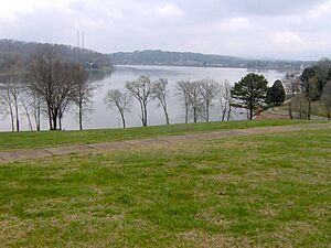
The Fort Southwest Point site sits on a hill. From this spot, you can see where the Tennessee River and the Clinch River meet. This meeting point is now part of Watts Bar Lake. This lake was formed when the Watts Bar Dam was finished in 1942. The Emory River also flows into the Clinch River about 5 miles (8 km) upstream.
Fort Southwest Point is part of Southwest Point Park. This park is both a historical site and a fun place for recreation. You can find the park along State Route 58. It's about 2 miles (3 km) south of Interstate 40. It's also about 1 mile (1.6 km) south of U.S. Route 70.
History of the Fort
The First Blockhouse: 1792-1797
During the American Revolutionary War in 1779, a man named Colonel Arthur Campbell suggested building a fort here. He thought the spot where the Clinch and Tennessee rivers meet would be perfect. After the war, many settlers moved into the Tennessee Valley. This led to more conflicts with the Cherokee people who lived there.
Two big things made Southwest Point very important. First, the Avery's Trace road was built in 1788. This road started at Southwest Point and was the main way to travel between East and Middle Tennessee until about 1800. Second, the Treaty of Holston was signed in 1791. This treaty set the border between U.S. lands and Cherokee lands at the Clinch River. This put Southwest Point right on the edge of new lands for settlers.
In the early 1790s, there were many attacks by the Chickamauga Cherokee against the settlers. The governor at the time, William Blount, kept the army ready to protect people. John Sevier, a military leader, set up camp at Southwest Point in 1792. By November of that year, his troops had built a blockhouse there. A blockhouse is a small, strong fort. They used it as a base until federal troops arrived in 1793.
Fort Southwest Point: 1797-1811
From 1793 to 1796, a small group of federal soldiers lived at the Southwest Point Blockhouse. During this time, a decision was made to build a much bigger fort. Records about the fort's building were lost in a fire. However, historians know that federal troops finished the fort in July 1797. Captain John Wade and Captain Richard Sparks led these troops.
The fort was first called "Fort Butler" after Lieutenant-Colonel Thomas Butler. He was the commander of federal forces in East Tennessee. But by 1798, its name had changed to "Fort Southwest Point."
Lieutenant-Colonel Butler moved his main office to Fort Southwest Point in 1799. At this time, about 400-500 soldiers were stationed there. They included infantry (foot soldiers), artillery (cannon users), and dragoons (mounted soldiers). Around the same time, land was sold for what would become the city of Kingston. It was named after Major Robert King, an officer at the fort.
One of the first jobs for the soldiers was to remove people called "squatters." These were people who had settled on Cherokee lands without permission. However, the first Treaty of Tellico in 1798 helped solve many of these problems. This treaty reduced the need for so many soldiers. By 1801, only about 100 soldiers were left at Fort Southwest Point.
In 1801, Colonel Return J. Meigs became the Cherokee Agent. This meant he worked for the U.S. government to deal with the Cherokee. He also managed military affairs for the War Department in Tennessee. Even with fewer soldiers, Fort Southwest Point was important. It was Meigs's office and a place to give out the Cherokee "annuity." This was an annual payment of goods from the U.S. government in exchange for land.
Meigs soon started talking with the Cherokee. He wanted permission to build a wagon road across their lands. This road would connect Knoxville and Nashville. In 1805, the Third and Fourth Treaties of Tellico were signed. These treaties gave the U.S. control over most of the Cumberland Plateau. This made the road possible. As the treaties moved the U.S.-Cherokee border south, the fort was no longer needed. By 1807, Meigs and most of the soldiers had moved to the Hiwassee area. A very small group of soldiers stayed at Fort Southwest Point until 1811.
What Archaeologists Found
The Tennessee Valley Authority bought the Southwest Point site in the 1930s. This was before the Watts Bar Dam was built. In 1973, the University of Tennessee started digging at the site. They found six old buildings and signs that people lived there long before the fort. Between 1984 and 1986, the Tennessee Division of Archaeology did more digging. They wanted to find information to help rebuild the fort. These digs uncovered nine more buildings and the ditch where the fort's wall (palisade) once stood. This helped researchers figure out the fort's original design.
Archaeologists also found things from prehistoric times. These included an infant burial, storage pits, and pieces of pottery. They found hickory nut shells in an old fireplace. Scientists used radiocarbon dating to find out these shells were from about 1360 AD.
Fort Buildings and Layout
Archaeological findings show that Fort Southwest Point was quite large. It measured about 297 feet (90.5 m) by 175 feet (53.3 m). This enclosed an area of about 1.2 acres (0.5 hectares). There were at least 15 buildings inside the fort. Their layout was figured out mostly from the remains of their foundations.
- Structure 1 — This building was about 17 feet (5.2 m) by 22 feet (6.7 m). It was likely a corner blockhouse, a small defensive tower.
- Structure 2 — This was a deep vault, about 14 feet (4.3 m) deep. It was probably a privy, which is an old word for an outdoor toilet.
- Structure 3 — This large building was about 70 feet (21.3 m) by 22 feet (6.7 m). It probably housed the officers and administrative offices.
- Structure 4 — This building was about 62 feet (18.9 m) by 22 feet (6.7 m). It was likely barracks, where soldiers lived. It even had a drain that sent water to a cistern (a tank for collecting water).
- Structure 5 — Another building, about 62 feet (18.9 m) by 22 feet (6.7 m), also likely barracks.
- Structure 6 — This building was about 43.5 feet (13.3 m) by 22 feet (6.7 m), probably more barracks.
- Structure 7 — This structure was approximately 83 feet (25.3 m) by 22 feet (6.7 m).
- Structure 8 — About 43 feet (13.1 m) by 22 feet (6.7 m), possibly a distribution center for supplies.
- Structure 9 — Another vault, about 8 feet (2.4 m) by 10 feet (3 m) and 10.5 feet (3.2 m) deep. This was also likely a privy.
- Structure 10 — About 22 feet (6.7 m) by 18 feet (5.5 m), probably another corner blockhouse.
- Structure 11 — Approximately 17 feet (5.2 m) by 18 feet (5.5 m), likely a blockhouse.
- Structure 12 — Similar to Structures 2 and 9, probably a privy.
- Structure 13 — Similar to Structures 10 and 11, probably a blockhouse.
- Structure 14 — About 63 feet (19.2 m) by 17 feet (5.2 m), likely barracks.
- Structure 15 — About 62 feet (18.9 m) by 23 feet (7 m), probably a supply building.
See also
 | Delilah Pierce |
 | Gordon Parks |
 | Augusta Savage |
 | Charles Ethan Porter |


