
Watts Bar Dam facts for kids
Quick facts for kids Watts Bar Dam |
|
|---|---|

Watts Bar Dam
|
|

Location of Watts Bar Dam in Tennessee
|
|
| Official name | Watts Bar Dam |
| Location | Meigs County and Rhea County, Tennessee, United States |
| Coordinates | 35°37′16.69″N 84°46′53.75″W / 35.6213028°N 84.7815972°W |
| Construction began | July 1, 1939 |
| Opening date | January 1, 1942 |
| Operator(s) | Tennessee Valley Authority |
| Dam and spillways | |
| Impounds | Tennessee River |
| Height | 112 ft (34 m) |
| Length | 2,960 ft (900 m) |
| Reservoir | |
| Creates | Watts Bar Lake |
| Total capacity | 1,175,000 acre⋅ft (1,449,000 dam3) |
| Catchment area | 17,310 sq mi (44,800 km2) |
| Power station | |
| Commission date | 1941-1944 |
| Turbines | 5 x 38 MW Kaplan-type |
| Installed capacity | 190 MW |
The Watts Bar Dam is a large hydroelectric dam located on the Tennessee River in Meigs and Rhea counties in Tennessee, United States. It's one of nine dams on the main Tennessee River channel. The Tennessee Valley Authority (TVA), a government agency, built this dam in the early 1940s. Its main jobs are to control floods, create electricity, and help ships travel easily along the river.
The dam creates Watts Bar Lake, which is about 39,090-acre (15,820 ha) big. It also marks the end of Watts Bar Lake and the start of Chickamauga Lake, which stretches south towards Chattanooga. The dam gets its name from Watt Island, a sandbar that was there before the dam was built.
Contents
Where is Watts Bar Dam Located?
Watts Bar Dam is about 530 miles (850 km) upstream from where the Tennessee River flows into another river. It's located roughly halfway between the cities of Knoxville and Chattanooga. Just north of the dam, the Piney River flows into the Tennessee River. The closest towns are Spring City to the northwest and Decatur to the south. You can drive across Watts Bar Dam on Tennessee State Route 68, which connects to bigger highways like Interstate 75 and U.S. Route 27.
How Big is Watts Bar Dam?
Watts Bar Lake stretches for about 72.4 miles (116.5 km) northeast from the dam all the way to Fort Loudoun Dam. It covers parts of Meigs, Rhea, Roane, and Loudon counties. Besides the main Tennessee River channel, you can also navigate boats on the lower 23 miles (37 km) of the Clinch River and the lower 12 miles (19 km) of the Emory River. Many cities, like Kingston, Spring City, Harriman, Loudon, Rockwood, and Lenoir City, are located along Watts Bar Lake.
Watts Bar Lake has about 722 miles (1,162 km) of shoreline and over 39,090 acres (15,820 ha) of water. The Watts Bar Dam itself is 112 feet (34 m) high and stretches 2,960 feet (900 m) across the Tennessee River. It can hold 1,175,000 acre⋅ft (1,449,000 dam3) of water, and it has a special space to hold 379,000 acre⋅ft (467,000 dam3) of water during floods. The dam's power plant generates 175 megawatts of electricity. There's also a navigational lock that is 360 by 60 feet (110 m × 18 m) big. This lock helps boats move up and down 70 feet (21 m) between Watts Bar Lake and Chickamauga Lake.
Building the Dam: A Look Back

People knew that Watt Island was a good spot for a dam way back in the 1870s. The U.S. Army Corps of Engineers even built a small wall there to help the river flow better. They also dug out the river channel between 1911 and 1913 to make it deeper. In 1930, they suggested building a dam at this spot.
In 1936, the Tennessee Valley Authority (TVA) took over the project. TVA had a big plan to build and buy many dams along the Tennessee River. Their goal was to make it easier for boats to travel, control floods, and help the region's economy grow. TVA got permission to build the dam at Watt Island on March 16, 1939, and construction officially started on July 1, 1939.

Building Watts Bar Dam and the lake behind it meant buying about 54,600 acres (22,100 ha) of land. Over 7,304 acres (2,956 ha) of this land was covered in trees and had to be cleared. Many families (832 of them!), 17 cemeteries, and 121 miles (195 km) of roads had to be moved. A dirt wall was built to protect downtown Kingston from the rising water. Some changes were also needed for the riverfronts of Spring City, Harriman, Wheat, and Loudon. The entire community of Rhea Springs, which was along the Piney River, was completely covered by the new lake.

The dam was first designed to have three generators to make electricity. But when World War II started in 1941, the need for electricity in the area grew very quickly. So, the plan was changed to add a fourth and fifth generator. The dam was finished, and its gates were closed on January 1, 1942. The first generator started making power on February 11, 1942. The second started on April 6, and the third on July 23 of the same year. The fourth generator began working on March 12, 1944, and the fifth on April 24, 1944. The dam's lock, which helps boats pass through, started operating on February 16, 1942.
In 2008, Watts Bar Lake was affected by a large spill of fly ash from the Kingston Fossil Plant coal fly ash slurry spill.
Images for kids
-
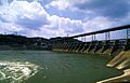
Watts Bar Dam
-
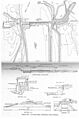
TVA's design plan for Watts Bar Dam, circa 1939
-

Workers test a turbine shaft at Watts Bar, June 1942
-

Earl M. Qualls, car dumper operator at Watts Bar, in June 1942.
