Meigs County, Tennessee facts for kids
Quick facts for kids
Meigs County
|
|
|---|---|

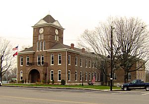
Meigs County Courthouse in Decatur
|
|

Location within the U.S. state of Tennessee
|
|
 Tennessee's location within the U.S. |
|
| Country | |
| State | |
| Founded | 1836 |
| Named for | Return J. Meigs |
| Seat | Decatur |
| Largest town | Decatur |
| Area | |
| • Total | 217 sq mi (560 km2) |
| • Land | 195 sq mi (510 km2) |
| • Water | 22 sq mi (60 km2) 10%% |
| Population
(2020)
|
|
| • Total | 12,758 |
| • Density | 60/sq mi (20/km2) |
| Time zone | UTC−5 (Eastern) |
| • Summer (DST) | UTC−4 (EDT) |
| Congressional district | 4th |
Meigs County is a county in the state of Tennessee, USA. It is a place where about 12,758 people live, according to the 2020 census. The main town and county seat of Meigs County is Decatur. This county is also part of the larger Athens, Tennessee area.
Contents
History of Meigs County
Before 1819, the land that is now Meigs County belonged to the Cherokee nation. Native American groups had lived here for thousands of years. European traders started visiting the Cherokee in the late 1600s. They came from colonies like Virginia and South Carolina.
After the American Revolutionary War, more American settlers moved into the area. They set up ferries across the Tennessee River as early as 1807. Colonel Return J. Meigs, who the county is named after, was a special US agent for Native American affairs. He worked with the Cherokee until 1817. His office then moved to what is now Meigs County.
In 1819, the US government made a deal with the Cherokee called the Calhoun Treaty. This treaty forced the Cherokee to give up their lands north of the Hiwassee River. This opened the land for new settlers. Meigs County was officially created by the Tennessee government in 1836. It was made from parts of Rhea County.
In 1830, the United States Congress passed the Indian Removal Act. This law forced many Native American tribes, including the Cherokee, to move from their homes in the Southeast. The Cherokee were the last to be moved. They were held in special camps in Tennessee and Alabama. Then, they were forced to walk a very long distance to Indian Territory (which is now Oklahoma). This sad journey is known as the "Trail of Tears." Many Cherokee people crossed the Tennessee River at Blythe Ferry in Meigs County.
When the Civil War began in June 1861, people in Meigs County had to choose sides. Most people in East Tennessee wanted to stay with the Union. But Meigs County voted to leave the Union. The vote was 481 for leaving and 267 against. Even so, the county had people who fought for both the Union and the Confederate sides during the war.
Meigs County in the 20th Century
In 1985, a local group called the Meigs County Family and Community Education (FCE) Club started a special project. They made a large quilt to celebrate the early history of Meigs County. This was part of Tennessee's 1986 Homecoming celebrations. The quilt shows fourteen important historical places in Meigs County.
The main design of the quilt, including a map, was created by Flossie Bennett. She was a long-time leader of the FCE. A committee chose which places to include on the quilt.
These places included:
- the Elisha Sharp House (built around 1825)
- the Stewart House (1830)
- R. H. Johnson's stable
- Mount Zion church and Cemetery (1830)
- Zeigler's Mill (1850)
- the Washington Ferry (1808)
- Pisgah Church (1818)
- the old gymnasium (around 1822)
- the old Meigs County Courthouse (1904)
- the old Volunteer Electric Cooperative Building (1935)
- the Ashley House (1885)
- the Sam Eaves Store (around 1861)
The quilt also featured Hereford cattle. Meigs County is well-known for its beef cattle. The quilt won an award for "Best Original Design." It was first shown at the Meigs-Decatur Public Library. Now, you can see it at the Meigs County Historical Museum in Decatur.
A new building for the Meigs County Historical Museum opened in Decatur in July 2002. The museum keeps many old court and family records. It also has a large painting, called a mural, that shows Main Street in Decatur in the 1930s. This mural was painted by a local artist named Bill McDonald.
Geography of Meigs County
Meigs County covers a total area of about 217 square miles. About 195 square miles of this is land, and 22 square miles (10%) is water.
The most important natural feature in Meigs County is the Tennessee River. This river forms the western edge of the county. The Watts Bar Dam is located on the river between Meigs and Rhea counties. Above the dam is Watts Bar Lake, a large lake created by the dam. Below the dam, the river becomes part of Chickamauga Lake. The Hiwassee River also flows into the Tennessee River in the southwestern part of Meigs County.
Neighboring Counties
Meigs County shares borders with these other counties:
- Roane County, Tennessee (north)
- McMinn County, Tennessee (east)
- Bradley County, Tennessee (southeast)
- Hamilton County, Tennessee (south)
- Rhea County, Tennessee (west)
Protected Natural Areas
Parts of these protected areas are found in Meigs County:
- Chickamauga Wildlife Management Area
- Hiwassee Refuge
Population of Meigs County
| Historical population | |||
|---|---|---|---|
| Census | Pop. | %± | |
| 1840 | 4,794 | — | |
| 1850 | 4,879 | 1.8% | |
| 1860 | 4,667 | −4.3% | |
| 1870 | 4,511 | −3.3% | |
| 1880 | 7,117 | 57.8% | |
| 1890 | 6,930 | −2.6% | |
| 1900 | 7,491 | 8.1% | |
| 1910 | 6,131 | −18.2% | |
| 1920 | 6,077 | −0.9% | |
| 1930 | 6,127 | 0.8% | |
| 1940 | 6,393 | 4.3% | |
| 1950 | 6,080 | −4.9% | |
| 1960 | 5,160 | −15.1% | |
| 1970 | 5,219 | 1.1% | |
| 1980 | 7,431 | 42.4% | |
| 1990 | 8,033 | 8.1% | |
| 2000 | 11,086 | 38.0% | |
| 2010 | 11,753 | 6.0% | |
| 2020 | 12,758 | 8.6% | |
| U.S. Decennial Census 1790-1960 1900-1990 1990-2000 2010-2014 |
|||
2020 Census Information
The 2020 United States census counted 12,758 people living in Meigs County. There were 4,938 households and 3,331 families.
| Race | Number | Percentage |
|---|---|---|
| White (non-Hispanic) | 11,823 | 92.67% |
| Black or African American (non-Hispanic) | 131 | 1.03% |
| Native American | 58 | 0.45% |
| Asian | 26 | 0.2% |
| Pacific Islander | 1 | 0.01% |
| Other/Mixed | 499 | 3.91% |
| Hispanic or Latino | 220 | 1.72% |
Transportation in Meigs County
Several important roads help people travel through Meigs County:
- State Route 58: This is the main north-south highway. It runs through the middle of the county. It also has a bridge over the Hiwassee River.
- State Route 30: This is the main east-west highway. It crosses Highway 58 in Decatur. The state is making this road bigger, from two lanes to four lanes. This will make it easier to connect to Interstate 75.
- State Route 68: This highway runs mostly north-south, but it goes east-west in the northern part of the county. It crosses the Tennessee River at Watts Bar Dam.
- State Route 60: This is a main north-south highway that forms the southern border of the county.
- State Route 304: This local road is important for people living nearby. It also leads to many marinas and campgrounds on Watts Bar Lake. It connects the community of Ten Mile to Decatur.
- State Route 305: This local road connects Interstate 75 with Tennessee State Route 68 and Tennessee State Route 58. It also links the northern part of the county to Athens in McMinn County.
- State Route 306: This is a smaller state highway in the southeast of the county. It connects Highway 58 to Charleston and Cleveland.
Communities in Meigs County

Town
- Decatur (This is the county seat, where the main government offices are.)
Unincorporated Communities
These are smaller communities that are not officially towns:
- Big Spring
- Birchwood (partially in Meigs County)
- Euchee
- Georgetown (partially in Meigs County)
- Ten Mile (partially in Meigs County)
Ghost Town
- Cute (This is a place where people used to live, but now it's mostly empty.)
See also
 In Spanish: Condado de Meigs (Tennessee) para niños
 | John T. Biggers |
 | Thomas Blackshear |
 | Mark Bradford |
 | Beverly Buchanan |

