
McMinn County, Tennessee facts for kids
Quick facts for kids
McMinn County
|
||
|---|---|---|

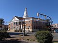
McMinn County Courthouse in Athens
|
||
|
||

Location within the U.S. state of Tennessee
|
||
 Tennessee's location within the U.S. |
||
| Country | ||
| State | ||
| Founded | 1819 | |
| Named for | Joseph McMinn | |
| Seat | Athens | |
| Largest city | Athens | |
| Area | ||
| • Total | 432 sq mi (1,120 km2) | |
| • Land | 430 sq mi (1,100 km2) | |
| • Water | 2.1 sq mi (5 km2) 0.5%% | |
| Population
(2020)
|
||
| • Total | 53,794 |
|
| • Density | 125.10/sq mi (48.30/km2) | |
| Time zone | UTC−5 (Eastern) | |
| • Summer (DST) | UTC−4 (EDT) | |
| Congressional district | 3rd | |

McMinn County is a place in Tennessee, a state in the United States. It's found in the eastern part of Tennessee. In 2020, about 53,794 people lived there. The county covers about 432 square miles. Much of the county is in the Appalachian Mountains, a region with many ridges and valleys. The main town and county seat is Athens. McMinn County is also part of the Athens, TN Micropolitan Statistical Area, along with Meigs County.
Contents
History of McMinn County
McMinn County was created in 1819 from land that once belonged to Native American tribes. It was named after Joseph McMinn (1758–1824). Joseph McMinn was a military leader during the American Revolutionary War. He also served in the state government and became the governor of Tennessee. He passed away in 1824 and is buried in Calhoun.
Early Railroads and Towns
The first railroad in East Tennessee started being built in McMinn County in the late 1830s. This project faced money problems and stopped for a while. Work began again in 1849, and by the mid-1850s, train lines connected major cities like Chattanooga and Knoxville. The main office for this railroad was in Athens before it moved in 1855. An old train station from this time can still be seen in Niota. Many towns grew up along these new railroads. These include Etowah, which got a large train station in the early 1900s, and Englewood, which became a center for making textiles.
McMinn County During the Civil War
Like many areas in East Tennessee, McMinn County had different opinions about the American Civil War. On June 8, 1861, the county voted against leaving the United States. More people wanted to stay in the Union than join the Confederacy. During the war, McMinn County sent 12 groups of soldiers to fight for the Union Army. They also sent eight groups of soldiers to fight for the Confederate Army.
Women's Right to Vote
On August 18, 1920, a very important vote happened in Tennessee. State Representative Harry T. Burn from Niota cast the deciding vote. This vote helped to approve the Nineteenth Amendment. This amendment gave women the right to vote across the United States. Harry Burn said a letter from his mother, Febb Ensminger Burn, helped him decide how to vote. Even though people in McMinn County had different ideas about women voting, they reelected Burn to the state government a few months later.
The Battle of Athens
In August 1946, an event called the Battle of Athens took place. The local sheriff and other county officials were accused of trying to cheat in an election. A group of World War II veterans protested. They surrounded the jail in Athens, where the officials had taken the ballot boxes. After some conflict, the officials gave up the ballot boxes. The votes were then counted openly, showing that the veterans' chosen candidates had won the election.
Large Vehicle Accident
On December 11, 1990, a large accident happened on Interstate 75 near Calhoun. It involved 99 vehicles in heavy fog. Twelve people died and 42 were hurt. This accident was one of the biggest vehicle crashes in U.S. history at the time. Some people thought the fog was made worse by a nearby paper mill.
Geography and Nature

McMinn County covers about 432 square miles. Most of this area is land (430 square miles), and a small part is water (2.1 square miles). Most of the county is in the Appalachian Mountains. This area has many long, parallel ridges and valleys that run from northeast to southwest. The Hiwassee River forms the border with Bradley County to the southwest. Starr Mountain, a large ridge, is in the southeastern part of the county. It forms part of the border with Polk County and Monroe County.
Neighboring Counties
- Roane County (north)
- Loudon County (northeast)
- Monroe County (east)
- Polk County (southeast)
- Bradley County (southwest)
- Meigs County (west)
Protected Natural Areas
- Cherokee National Forest (part)
- Chickamauga Wildlife Management Area (part)
People and Population
| Historical population | |||
|---|---|---|---|
| Census | Pop. | %± | |
| 1820 | 1,623 | — | |
| 1830 | 14,460 | 790.9% | |
| 1840 | 12,719 | −12.0% | |
| 1850 | 13,906 | 9.3% | |
| 1860 | 13,555 | −2.5% | |
| 1870 | 13,969 | 3.1% | |
| 1880 | 15,064 | 7.8% | |
| 1890 | 17,890 | 18.8% | |
| 1900 | 19,163 | 7.1% | |
| 1910 | 21,046 | 9.8% | |
| 1920 | 25,133 | 19.4% | |
| 1930 | 29,019 | 15.5% | |
| 1940 | 30,781 | 6.1% | |
| 1950 | 32,024 | 4.0% | |
| 1960 | 33,662 | 5.1% | |
| 1970 | 35,462 | 5.3% | |
| 1980 | 41,878 | 18.1% | |
| 1990 | 42,383 | 1.2% | |
| 2000 | 49,015 | 15.6% | |
| 2010 | 52,266 | 6.6% | |
| 2020 | 53,794 | 2.9% | |
| U.S. Decennial Census 1790–1960 1900–1990 1990–2000 2010–2014 |
|||
Population in 2020
| Race | Number | Percentage |
|---|---|---|
| White (not Hispanic) | 45,993 | 86.33% |
| Black or African American (not Hispanic) | 2,361 | 4.38% |
| Native American | 140 | 0.26% |
| Asian | 430 | 0.81% |
| Pacific Islander | 17 | 0.03% |
| Other/Mixed | 2,693 | 5.05% |
| Hispanic or Latino | 2,161 | 4.06% |
In 2020, there were 53,794 people living in McMinn County. There were 20,804 households and 13,685 families.
Population in 2010
In 2010, there were 52,266 people living in the county. The population density was about 121 people per square mile. Most people (about 92%) were White. About 4% were Black, and smaller numbers were Native American, Asian, or Pacific Islander. About 3% of the population was Hispanic or Latino.
About 27% of households had children under 18. More than half (about 54%) were married couples. The average household had about 2.46 people. The average family had about 2.94 people. The median age was 40.4 years old. About 22.57% of the people were under 18. About 16.86% were 65 or older.
The average income for a household was $37,146. For families, it was $47,726. About 17.3% of the population lived below the poverty line. This included 24% of those under 18.
Towns and Communities
Cities
- Athens (county seat)
- Etowah
- Niota
- Sweetwater
Towns
Census-Designated Place
Other Communities
Schools in McMinn County
For many years, schools in Tennessee were separated by race. After the Civil Rights Act of 1964, schools began to welcome all students.
McMinn County Schools runs public schools for most of the county, from kindergarten to 12th grade. This includes McMinn County High School and McMinn Central High School. In 2020, the district had 5,493 students. It had two high schools, seven middle schools, seven elementary schools, and seven preschools. In 2022, about 31% of elementary and middle school students were good at reading. About 40% were good at math. For high school students, 34% were good at reading and 22% were good at math.
Athens City Schools and the Etowah School District serve their own areas for grades K-8. Students from these areas then go to high schools run by McMinn County Schools.
Images for kids
-
McMinn County Courthouse in Athens
See also
 In Spanish: Condado de McMinn para niños
