Englewood, Tennessee facts for kids
Quick facts for kids
Englewood, Tennessee
|
|
|---|---|

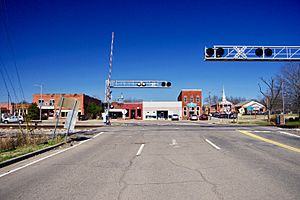
Main Street (SR 39)
|
|

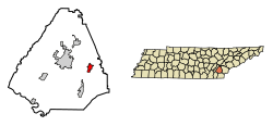
Location of Englewood in McMinn County, Tennessee.
|
|
| Country | United States |
| State | Tennessee |
| County | McMinn |
| Incorporated | 1919 |
| Named for | Inglewood Forest |
| Area | |
| • Total | 1.91 sq mi (4.95 km2) |
| • Land | 1.91 sq mi (4.95 km2) |
| • Water | 0.00 sq mi (0.00 km2) |
| Elevation | 860 ft (262 m) |
| Population
(2020)
|
|
| • Total | 1,550 |
| • Density | 776.44/sq mi (299.77/km2) |
| Time zone | UTC-5 (Eastern (EST)) |
| • Summer (DST) | UTC-4 (EDT) |
| ZIP code |
37329
|
| Area code(s) | 423 |
| FIPS code | 47-24040 |
| GNIS feature ID | 1283789 |
Englewood is a town located in McMinn County, Tennessee, in the United States. In 2020, about 1,550 people lived there. It is known for its history as a mill town, where factories once made things like cotton yarn and socks.
Contents
History of Englewood
Early Mill Town Days
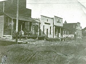
The story of Englewood began in 1857. A businessman named John Dixon started the Eureka Cotton Mills. These mills used cotton grown nearby to make yarn. A small community grew around the mill, and it was called Eureka Mills.
By 1875, Elisha Brient and his family took over the mills. In 1894, the Brients decided to change the town's name. Nancy Chestnutt, a relative, suggested "Englewood." She thought the area looked like the English forests she had read about in Robin Hood stories.
Moving to the Railroad
In the late 1800s, the Brient family started building new shops and mills. These were about 2 miles (3.2 km) northeast of their original mill town. This new spot was a train stop called Tellico Junction. It was important because two different railroads crossed there.
The Brients also made their Englewood operations bigger. They started a flour and feed mill with J.W. Chestnutt. In 1907, all the businesses in Englewood moved to Tellico Junction. This move helped them use the railroad more easily. The next year, Tellico Junction was renamed Englewood. The original mill town then became known as "Old Englewood."
Growth and Changes
In 1917, J.W. Chestnutt started the Englewood Manufacturing Company. They built a factory that made hosiery (like socks). Englewood grew a lot, with homes for 300 workers. It even had its own stores, a sawmill, and a school.
Different parts of town got nicknames:
- "Yellow Top" was where the cotton mill workers lived.
- "Socktown" was for the hosiery mill workers.
- "Onion Hill" was near the flour mill.
Many women worked in the mills, mostly as weavers. Men usually held the managing jobs.
Challenges and Legacy
During the Great Depression, the mills in Englewood had to close. Many people joined government work programs to find jobs. In World War II, the Eureka Cotton Mill was used again. It made clothes for countries affected by the war.
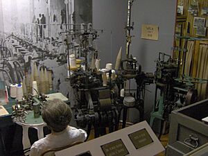
Over the years, other factories opened in Englewood. However, most of them closed by the late 1990s. The last mill, Allied Hosiery, shut down in 2008. Today, you can learn about the town's factory history at the Englewood Textile Museum.
Geography of Englewood
Englewood is located in the Chestuee Creek Valley. This valley was formed by a stream that flows into the Hiwassee River. The Hiwassee River is a few miles southwest of town. The Unicoi Mountains are part of the larger Blue Ridge Mountains. They can be seen dominating the view to the south.
The town covers about 1.7 square miles (4.4 square kilometers) of land. There is no water area within the town limits.
Roads and Connections
- U.S. Route 411 connects Englewood to Madisonville to the northeast. It also goes to Etowah to the south.
- Tennessee State Route 39 (also called South Niota Road and West Athens Street) connects Englewood to Athens. As Tellico Street, it connects Englewood to Tellico Plains to the east.
Population and People
| Historical population | |||
|---|---|---|---|
| Census | Pop. | %± | |
| 1920 | 1,271 | — | |
| 1930 | 1,471 | 15.7% | |
| 1940 | 1,342 | −8.8% | |
| 1950 | 1,545 | 15.1% | |
| 1960 | 1,574 | 1.9% | |
| 1970 | 1,878 | 19.3% | |
| 1980 | 1,840 | −2.0% | |
| 1990 | 1,611 | −12.4% | |
| 2000 | 1,590 | −1.3% | |
| 2010 | 1,532 | −3.6% | |
| 2020 | 1,483 | −3.2% | |
| Sources: | |||
How Many People Live Here?
As of the 2020 United States census, there were 1,550 people living in Englewood. There were 703 households, which are groups of people living together in one home. About 493 of these were families.
Most people in Englewood are White (87.42%). There are also smaller numbers of Black or African American, Native American, and Asian residents. About 5.22% of people are from other races or mixed races. About 6.58% of the population is Hispanic or Latino.
Life in Englewood Households
In 2020, about 31.8% of households had children under 18 living with them. About 51.5% were married couples. The average household had 2.37 people, and the average family had 2.94 people.
The population's age spread out like this:
- 25.9% were under 18 years old.
- 16.9% were 65 years or older.
The average age in Englewood was 36 years.
The median income for a household in Englewood was $24,000. This means half of the households earned more than this, and half earned less. About 20.1% of all people in Englewood lived below the poverty line. This included 24.7% of those under 18.
Education in Englewood
Students in Englewood attend public schools run by McMinn County Schools. These schools include Englewood Elementary School. Older students go to McMinn Central High School.
Englewood used to have its own high school, Englewood High School. But a fire destroyed it in December 1963. McMinn Central High School opened in the fall of 1966. It serves students from both Englewood and Etowah.
See also
 In Spanish: Englewood (Tennessee) para niños
 | Selma Burke |
 | Pauline Powell Burns |
 | Frederick J. Brown |
 | Robert Blackburn |


