Etowah, Tennessee facts for kids
Quick facts for kids
Etowah
|
|
|---|---|

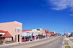
Tennessee Avenue (US 411) in Etowah
|
|

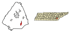
Location of Etowah in McMinn County, Tennessee.
|
|
| Country | United States |
| State | Tennessee |
| County | McMinn |
| Founded | 1906 |
| Incorporated | 1909 |
| Named for | Creek (Muskogee) word for "The Town", the nickname for Coosa, capital of the northern Creeks |
| Government | |
| • Type | Council/Manager |
| Area | |
| • Total | 2.83 sq mi (7.32 km2) |
| • Land | 2.83 sq mi (7.32 km2) |
| • Water | 0.00 sq mi (0.00 km2) |
| Elevation | 807 ft (246 m) |
| Population
(2020)
|
|
| • Total | 3,603 |
| • Density | 1,274.95/sq mi (492.27/km2) |
| Time zone | UTC-5 (Eastern (EST)) |
| • Summer (DST) | UTC-4 (EDT) |
| ZIP code |
37331
|
| Area code(s) | 423 |
| FIPS code | 47-24480 |
| GNIS feature ID | 1328151 |
Etowah is a city located in McMinn County in the state of Tennessee, United States. In 2020, the city had a population of 3,613 people.
Contents
History of Etowah
Etowah was started in 1906. It was mainly built as a stop for the Louisville & Nashville Railroad (L&N). This railroad created a more direct path between Atlanta and Cincinnati.
The exact meaning of the town's name isn't fully known. However, a local story says that a train crew brought a sign that said "Etowah" from the Etowah River, and the name stuck. The word "Etowah" comes from the Muskogee/Creek language, where italwa means "town."
In 1902, the Louisville and Nashville Railroad announced plans for a new, straighter line. This line would avoid the rough mountains of North Georgia and East Tennessee. They needed a place halfway between Atlanta and Cincinnati to fix trains and change crews. By the end of 1904, land was bought in McMinn County for this purpose. The city of Etowah was then planned. The L&N bought a large area of land to build a big rail center. They also planned a town to support the railroad workers.
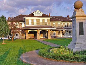
What was once a wet, swampy area quickly grew into a busy town by 1906. The L&N Depot became the center of business and social life. Over the years, Etowah has faced tough times and good times. For example, the L&N shops closed in the 1930s, but new businesses were brought in. Today, Etowah continues to grow with new industries and shops.
In 1974, a family from Etowah, the Tullocks, started a grocery store called Bargain Barn. This store has since grown into a large chain with many locations in several states. Also in 1974, a strong tornado affected southern Etowah. It caused damage to homes and sadly, some people lost their lives. This tornado was part of a very large group of storms known as the 1974 Super Outbreak.
Geography of Etowah
Etowah is located at coordinates 35°19′46″N 84°31′42″W / 35.32944°N 84.52833°W.
According to the United States Census Bureau, the city covers a total area of 2.8 square miles (7.2 square kilometers). All of this area is land.
Population Information
| Historical population | |||
|---|---|---|---|
| Census | Pop. | %± | |
| 1910 | 1,685 | — | |
| 1920 | 2,516 | 49.3% | |
| 1930 | 4,209 | 67.3% | |
| 1940 | 3,362 | −20.1% | |
| 1950 | 3,261 | −3.0% | |
| 1960 | 3,223 | −1.2% | |
| 1970 | 3,736 | 15.9% | |
| 1980 | 3,758 | 0.6% | |
| 1990 | 3,815 | 1.5% | |
| 2000 | 3,663 | −4.0% | |
| 2010 | 3,490 | −4.7% | |
| 2020 | 3,613 | 3.5% | |
| Sources: | |||
2020 Census Details
In 2020, the 2020 United States census counted 3,613 people living in Etowah. There were 1,256 households and 882 families in the city.
The population of Etowah is mostly White. There are also smaller groups of Black or African American, Native American, and Asian residents. About 5% of the population is Hispanic or Latino.
Education in Etowah
The Etowah City Elementary School District runs Etowah School, which teaches students from kindergarten through 8th grade. All of Etowah is part of this school district.
McMinn County Schools also operates Mountain View Elementary School. While it has an Etowah postal address, it is outside the city limits and does not serve students within Etowah city.
For high school, students in Etowah attend schools run by McMinn County Schools. McMinn Central High School serves students from 9th to 12th grade. This school is located between Etowah and Englewood. Before McMinn Central High School opened in 1966, students from Etowah attended Etowah High School.
Fun Places to Visit
The Historic L&N Depot museum in Downtown Etowah is a popular spot. Many people think it's the main attraction in this small town. This museum teaches visitors about the history of the railroad and the town.
The "Parkstown" neighborhood, which has a rich African-American history, has also become interesting for visitors. Another notable place in Etowah is the Gem Theater. This building was first built in 1927. The city of Etowah bought it in 1993. Now, the Gem Theater hosts local plays, concerts, movies, and other community events.
Local Industry
Etowah is home to a plant of the Waupaca Foundry, Inc. This plant, known as Plant number 6, makes high-quality metal parts. These parts are used in cars and farming equipment. For example, they make parts like control arms and brake calipers for popular vehicles. These include the new Ford F-series trucks, Dodge Caravan, Hummer H2, GMC Envoy, Chrysler 300C/Dodge Charger, and the Toyota Camry.
Etowah also mentions two other companies, Johns Manville and Huber. However, these plants are actually located just outside the city limits.
Notable People from Etowah
Many interesting people have come from Etowah, including:
- Paul Cantrell – A politician who served as a state senator.
- Al Clayton – A well-known photographer.
- Leon Daniel – A respected journalist.
- Steel Arm Dickey – A pitcher who played in the Negro leagues.
- Tom Saffell – A former major league outfielder in baseball.
- Thomas W. Steed – A United States military officer during World War II.
- Chris Whittle – An American executive known for his work in media and education.
See also
 In Spanish: Etowah (Tennessee) para niños
 | Toni Morrison |
 | Barack Obama |
 | Martin Luther King Jr. |
 | Ralph Bunche |


