Hiwassee River facts for kids
Quick facts for kids Hiwassee River |
|
|---|---|

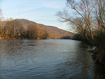
Near the bridge of U.S. Highway 411 in Tennessee. Gee Knob and Chestnut Mountain are on the left.
|
|

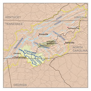
The Hiwassee drainage basin
|
|
| Country | United States |
| State | Georgia, North Carolina, Tennessee |
| Physical characteristics | |
| Main source | North slope of Rocky Mountain in Towns County, Georgia 3,640 ft (1,110 m) 34°48′4″N 83°44′4″W / 34.80111°N 83.73444°W |
| River mouth | Tennessee River at Hiwassee Island in Meigs County, Tennessee 682 ft (208 m) 35°24′36″N 85°0′36″W / 35.41000°N 85.01000°W |
| Length | 147 mi (237 km) |
| Basin features | |
| Progression | northwest |
| River system | Tennessee River |
| Basin size | 2,700 sq mi (7,000 km2) |
| Tributaries |
|
The Hiwassee River starts high up on the north side of Rocky Mountain in Towns County, Georgia. It flows north into North Carolina and then turns west into Tennessee. Finally, it joins the Tennessee River a few miles west of State Route 58 in Meigs County, Tennessee. The river is about 147 miles (237 km) long.
Contents
River Flow and Dams
The Tennessee Valley Authority (TVA) has built four dams on the Hiwassee River. These dams are all in Western North Carolina. They are the Chatuge Dam, Mission Dam, Hiwassee Dam, and Apalachia Dam.
At Apalachia Dam, some water is sent through a long pipeline. This pipeline goes through mountains for eight miles (13 km). The water then flows through the Apalachia Powerhouse to make electricity. Because of this, the part of the river between Apalachia Dam and the powerhouse has less water. The John Muir Trail in Cherokee National Forest follows this section of the river.
Scenic River Section
A 23-mile (37 km) part of the river is a Tennessee State Scenic River. This section runs from the North Carolina/Tennessee border to U.S. Highway 411 near Delano. It is managed for fun activities by the Tennessee Resource Management Division. This part of the river has rapids that range from easy (Class I) to more challenging (Class III). The difficulty depends on how much water is flowing.
River's Journey to the Tennessee River
After leaving the mountains, the Hiwassee River gets wider. It winds through the countryside of Polk and Bradley counties in Tennessee. U.S. Highway 411 crosses the river soon after it leaves the mountains.
Further downstream, U.S. Route 11 crosses the river at Calhoun and Charleston, Tennessee. Here, local businesses like Bowater Newsprint Mill use the river's water.
The river then connects with the Chickamauga Dam lake, which is near Chattanooga, Tennessee. Many marshes and wetlands are around the river here. These areas are great homes for wildlife and are popular for hunting and fishing.
Interstate 75 crosses the river where McMinn and Bradley counties meet. The Hiwassee keeps flowing west. SR 58 crosses it on its way to meet the Tennessee River. This area is enjoyed by people who like boating, fishing, and water skiing.
Major Streams Joining the Hiwassee
Important streams that flow into the Hiwassee River include Valley River, Nottely River, Coker Creek, Big Lost Creek, Spring Creek, Conasauga Creek, and the Toccoa/Ocoee River.
What's in a Name?
The Hiwassee River has been spelled in many ways over time. One common spelling is "Hiawassee," which is also the name of a town in Georgia. Other old spellings include Heia Wassea and Highwassee.
Some Cherokee people say the name comes from their word Ayuhwasi. This word means a meadow or a grassy field. The Muskogee (Creek) people have a different idea. They say the river's name is Koasati or Hitchiti. These are Muskogee language words for the copperhead snake. Even today, the river area is known for having many copperhead snakes.
A Look Back in Time
For many centuries before the Cherokee arrived, different groups of people who spoke Muskogean languages lived along this river. These groups were related to the Muscogee/Creek people.
The Cherokee people speak an Iroquoian language. It is thought they moved to the Southeast from northern areas near the Great Lakes. Most Iroquoian-speaking groups lived there, like the Haudenosaunee (Iroquois Confederacy).
Early European Visitors
Spanish explorers came to this region in the 1500s. Hernando de Soto likely crossed the Hiwassee River in 1541 AD. This was near where it meets the Tennessee River at Hiwassee Island. Later, Juan Pardo probably followed a path along the river in 1567 AD.
The names of towns and native words recorded by de Soto's writers can be understood using Muskogean dictionaries. Most of these words are from the Koasati and Hitchiti languages. None of them are Cherokee words.
Old European maps from the 1600s show the Hiwassee River Basin was home to mountain groups of the Apalachee and the Kusa. The Kusa were a powerful group of the South Appalachian Mississippian culture. They are believed to be ancestors of the Muscogee Creek people.
British Colonial Times
In the 1690s, English explorers and traders found that most of the river valley was home to Muskogean and Yuchi towns. At this time, Cherokee villages were mostly to the east and north of the river.
In 1714, traders from South Carolina gave guns to the Cherokee. They told them to attack the Yuchi villages on the Hiwassee River. Most of the men in one Yuchi town were away when the Cherokee attacked. The Cherokee killed the Yuchi who were left, as they had no guns.
In 1715, the Cherokee invited leaders from many Muskogean areas to a meeting. These areas later formed the Creek Confederacy. The meeting was at Tugaloo in South Carolina. The Cherokee murdered the Muskogean leaders while they slept. This started a 40-year war between the Muscogee Creek and the Cherokee.
Because the Creek groups were not fully united, the Cherokee took over the northeastern part of what is now Georgia. They pushed the Muskogee and Yuchi out of most of western North Carolina.
The Cherokee Homeland in the 1700s
By the early 1700s, the Hiwassee River and its smaller streams were part of Cherokee land. A town called "Hiwassee" (Ayuhwasi) was near where Peachtree Creek joins the river. Murphy, North Carolina later grew in this spot. Many Cherokee towns were along the Valley River, which flows into the Hiwassee. These towns, along with those on the Nantahala, were called the "Valley Towns" by English traders.
The main Cherokee town, Great Hiwassee (Ayuhwasi Egwahi), was in today's Polk County, Tennessee. This is where the Hiwassee River comes out of the mountains. Settlements on the western side of the mountains were known as the Overhill Towns.
Native Americans had several important paths through this area. The Great Trading Path, the Overhill Trading Path, and the Unicoi Turnpike followed much of the Hiwassee River. Another old path, the Warrior Path, went from southern lands to Great Hiwassee. Then it went up Conasauga Creek to the Cherokee town of Great Tellico.
The Kowita Creek people continued to fight the Cherokee. By the 1750s, they were very strong. They destroyed all the Cherokee towns in Georgia and the Hiwassee Valley. A 1755 map of the area showed "Deserted Cherokee Towns" over a large part of western North Carolina and northeastern Georgia.
In 1763, the Cherokee had to give up all their lands in North Carolina east of a certain line. This was a punishment for helping the French during the French and Indian War. The British then gave the Cherokee lands in northwestern Georgia.
American Revolutionary War Changes
During the American Revolution in 1776, some Cherokee families still lived east of the Appalachian Mountains. The Cherokee became allies of the British. They hoped to force the American settlers off their lands. They attacked and killed people on frontier farms in the Carolinas.
In response, American soldiers attacked. They destroyed most of the remaining Cherokee towns in North Carolina, South Carolina, and Georgia. The Cherokee survivors first fled to the Tennessee River valley. Many later moved southwest into northwestern Georgia and northeastern Alabama. Some Cherokee returned to the Hiwassee Valley after the war. However, the main center of Cherokee culture had moved further south and west.
The Indian Removal Act of 1830 led to the forced removal of almost all members of the Five Civilized Tribes from the Southeast. The Cherokee were divided on whether to move to Indian Territory. Most were against it. But some leaders signed the New Echota Treaty to give up their lands. They hoped to get a good deal from the U.S. government, believing they would have to move anyway.
Finally, in 1838-1839, U.S. soldiers forced the Cherokee west on the Trail of Tears. The government built camps in northern Alabama and along the Hiwassee River in Tennessee. One of the biggest camps was Fort Cass near Charleston, Tennessee. It was on the south bank of the Hiwassee River.
Interesting Facts About the Hiwassee
The Hiwassee River flows through downtown Murphy, North Carolina. This place is famous in Cherokee Indian mythology. The legend tells of a huge, house-sized leech. This leech could control the water and use it to pull people to the bottom of the river and eat them. It was known as Tlanusi-yi, which means "The Leech Place."
The river is popular for whitewater rafting, whitewater canoeing, and whitewater kayaking. Many people enjoy fishing here, and there are businesses that help with fishing trips.
The Interstate 75 bridge crosses the Hiwassee between McMinn and Bradley counties in Tennessee. In December 1990, there was a large accident involving 99 vehicles here. It happened during very foggy weather, near a paper mill in the valley. Since then, a big system of warning signs and lights has been built on that part of Interstate 75. These signs warn drivers about bad weather like heavy rains and thick fog. This helps prevent serious crashes.
 | Selma Burke |
 | Pauline Powell Burns |
 | Frederick J. Brown |
 | Robert Blackburn |

