Polk County, Tennessee facts for kids
Quick facts for kids
Polk County
|
||
|---|---|---|
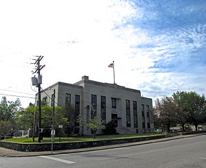
Polk County Courthouse in Benton
|
||
|
||

Location within the U.S. state of Tennessee
|
||
 Tennessee's location within the U.S. |
||
| Country | ||
| State | ||
| Founded | November 28, 1839 | |
| Named for | James K. Polk | |
| Seat | Benton | |
| Largest town | Benton | |
| Area | ||
| • Total | 442 sq mi (1,140 km2) | |
| • Land | 435 sq mi (1,130 km2) | |
| • Water | 7.7 sq mi (20 km2) 1.7%% | |
| Population
(2020)
|
||
| • Total | 17,544 |
|
| • Density | 40.33/sq mi (15.57/km2) | |
| Time zone | UTC−5 (Eastern) | |
| • Summer (DST) | UTC−4 (EDT) | |
| Congressional district | 3rd | |
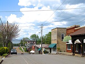
Polk County is a county located in the southeastern part of Tennessee, a state in the United States. In 2020, about 17,544 people lived there. The main town and county seat is Benton.
Polk County was created on November 28, 1839. It was formed from parts of Bradley and McMinn counties. The county was named after James K. Polk, who was the governor of Tennessee at the time and later became a U.S. president. Polk County is part of the larger Cleveland, Tennessee Metropolitan Area.
Contents
History of Polk County
Early Inhabitants and Cherokee Removal
Before European settlers arrived, Polk County was home to the Cherokee people for thousands of years. In 1819, the Cherokee Nation gave up the northern part of what is now Polk County to the U.S. government. The rest of the county was known as the Ocoee District.
Between 1838 and 1839, the Cherokee people were forced to leave their homes in this area. They were moved to a new territory, a journey known as the Trail of Tears.
Founding the County and Copper Mining
The Tennessee General Assembly officially created Polk County on November 23, 1839. The town of Benton was chosen as the county seat after an election on February 4, 1840.
In 1843, copper was discovered in a place called Ducktown. By the 1850s, a large mining operation began in southeastern Polk County. This area became known as the Copper Basin. Copper mining continued to be a major industry until the last mine closed in 1987.
Polk County During the Civil War
During the American Civil War, Polk County was one of the few counties in East Tennessee that supported the Confederacy. In June 1861, the county voted to leave the United States.
The copper mines in Polk County were very important during the war. They provided about 90% of the copper used by the Confederacy. When Union forces captured these mines after the Battles for Chattanooga in November 1863, it was a big loss for the Confederacy. There were also some conflicts and raids in the county during the war.
Building Dams and Power Plants
The East Tennessee Power Company built two hydroelectric dams on the Ocoee River. Ocoee Dam No. 1 was finished in 1911, and Ocoee Dam No. 2 was finished in 1913. These dams use the river's water to create electricity.
Later, the Tennessee Valley Authority (TVA), which started in 1933, bought the power company. TVA built another dam, Ocoee Dam No. 3, in 1943. They also built the powerhouse for Apalachia Dam on the Hiwassee River, which was also completed in 1943.
"Polkstock" Music Festival
In 1973, a large music festival was planned for a farm north of Benton. It was called the "Midwest Monster Peace Jubilee and Music Festival," but many people nicknamed it "Polkstock" because it was similar to the famous Woodstock festival. Organizers expected about 500,000 people to attend.
However, many local residents, especially religious groups, were against the festival. They worried about the impact of such a large event. The festival was eventually stopped by a state court.
Fireworks Factory Explosion
On May 27, 1983, there was a large explosion at a fireworks factory near Benton. The factory was not licensed, and it was producing illegal fireworks. The explosion caused a significant tragedy, affecting many workers. This was considered the largest illegal fireworks operation found in the United States at that time.
Olympic Games and Gun Sanctuary
The Ocoee Whitewater Center in Polk County was chosen as the site for the canoe slalom events during the 1996 Summer Olympics. These Olympic Games were mainly held in Atlanta, Georgia.
In April 2019, Polk County became the first county in Tennessee to be a "gun sanctuary." This means the county supports the Second Amendment right to own guns.
Geography of Polk County
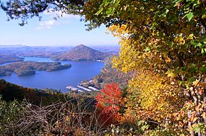
Polk County covers about 442 square miles. Most of this area, about 435 square miles, is land, and 7.7 square miles is water. It is the most southeastern county in Tennessee. This means it shares borders with both Georgia and North Carolina.
Mountains and Rivers
Most of Polk County is mountainous, part of the southern Blue Ridge Mountains. These are a section of the larger Appalachian Mountains. The western edge of the county has a different type of terrain called the Ridge-and-Valley Appalachians.
The highest point in the county is Big Frog Mountain, which is about 4,224 feet tall. A large part of Polk County, about 80%, is covered by the Cherokee National Forest.
The Ocoee River flows through Polk County. This river is famous for whitewater rafting and was used for the 1996 Olympics. The calmer Hiwassee River in northern Polk County is also popular for rafting and tubing. The Conasauga River is unique because it's the only river in Tennessee that doesn't flow into the Mississippi River Basin. Most of the people in Polk County live in the western, less mountainous parts or in the Copper Basin area.
Neighboring Counties
Polk County shares its borders with these other counties:
- Monroe County (to the northeast)
- Cherokee County, North Carolina (to the east)
- Fannin County, Georgia (to the southeast)
- Murray County, Georgia (to the southwest)
- Bradley County (to the west)
- McMinn County (to the northwest)
Protected Natural Areas
Polk County has several protected natural areas:
- Big Frog Wilderness (part of it)
- Cherokee National Forest (part of it)
State Protected Areas
- William L. Davenport Refuge
- Ducktown Basin Museum and Burra Burra Mine (a state historic site)
- Fourth Fractional Township Wildlife Management Area
- Hiwassee/Ocoee Scenic River State Park
Polk County Population and People
| Historical population | |||
|---|---|---|---|
| Census | Pop. | %± | |
| 1840 | 3,570 | — | |
| 1850 | 6,338 | 77.5% | |
| 1860 | 8,726 | 37.7% | |
| 1870 | 7,369 | −15.6% | |
| 1880 | 7,269 | −1.4% | |
| 1890 | 8,361 | 15.0% | |
| 1900 | 11,357 | 35.8% | |
| 1910 | 14,116 | 24.3% | |
| 1920 | 14,243 | 0.9% | |
| 1930 | 15,686 | 10.1% | |
| 1940 | 15,473 | −1.4% | |
| 1950 | 14,074 | −9.0% | |
| 1960 | 12,160 | −13.6% | |
| 1970 | 11,669 | −4.0% | |
| 1980 | 13,602 | 16.6% | |
| 1990 | 13,643 | 0.3% | |
| 2000 | 16,050 | 17.6% | |
| 2010 | 16,825 | 4.8% | |
| 2020 | 17,544 | 4.3% | |
| U.S. Decennial Census 1790-1960 1900-1990 1990-2000 2010-2014 |
|||
Who Lives in Polk County?
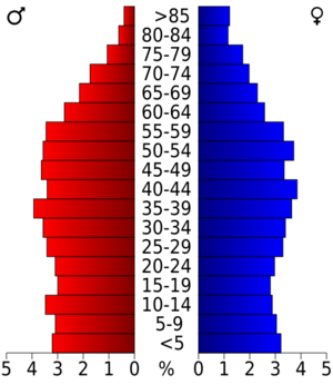
As of the 2020 United States census, there were 17,544 people living in Polk County. There were 7,383 households and 5,239 families.
Most people in Polk County are White, making up about 92.98% of the population. Other groups include Black or African American (0.35%), Native American (0.34%), Asian (0.19%), and Pacific Islander (0.06%). About 4.39% of people identify as other races or mixed races. People of Hispanic or Latino background make up about 1.69% of the population.
In 2010, the average household had about 2.49 people, and the average family had 2.96 people. About 22.14% of the population was under 18 years old. The median age in the county was 42.5 years.
Economy and Jobs in Polk County
For a long time, the copper mines in the Copper Basin were the biggest source of jobs in Polk County. As copper mining became less common, tourism started to grow.
Tourism and Whitewater Rafting
The first company offering rafting trips on the Hiwassee River started in 1969. In 1976, repairs to Ocoee Dam No. 2 made it possible for people to raft the rapids of the Ocoee River. Several rafting companies began during this time.
An agreement was made in 1984 with TVA to release water from the dam at certain times. This allows whitewater rafting to continue. This agreement was renewed in 2017.
Today, tourism related to rafting, kayaking, and canoeing on the Hiwassee and Ocoee Rivers is the largest part of Polk County's economy. More than 250,000 people visit the area each year for these activities. The Ocoee River is now the most rafted river in the United States. Both rivers are among the most popular tourist attractions in Tennessee.
Education in Polk County
Public schools in Polk County are managed by the Polk County Schools district.
High Schools
- Copper Basin High School
- Polk County High School
Middle Schools
- Chilhowee Middle School
Elementary Schools
- Benton Elementary School
- South Polk Elementary School
- Copper Basin Elementary School
Communities in Polk County
Cities
Town
- Benton (This is the county seat, the main town where the county government is located.)
Other Communities
Transportation in Polk County
Major Roads
Airports
Polk County has two airports:
- Martin Campbell Field: This is a general aviation airport, meaning it's used for private planes and smaller aircraft.
- Chilhowee Gliderport: This airport near Benton is specifically for gliders, which are aircraft that fly without an engine.
Notable People from Polk County
- Stan Beaver, a musician.
- Landrum Bolling, a journalist.
- Joel Eaves, a basketball coach.
- G. Earl Guinn, a university president.
- Elizabeth Hamer Kegan, a librarian.
- John E. Hutton, a U.S. representative.
- J. Chris Newton, a politician.
See also
 In Spanish: Condado de Polk (Tennessee) para niños
 | William L. Dawson |
 | W. E. B. Du Bois |
 | Harry Belafonte |


