Fannin County, Georgia facts for kids
Quick facts for kids
Fannin County
|
||
|---|---|---|

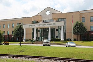
Fannin County Courthouse in Blue Ridge
|
||
|
||

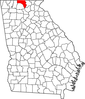
Location within the U.S. state of Georgia
|
||
 Georgia's location within the U.S. |
||
| Country | ||
| State | ||
| Founded | 1854 | |
| Named for | James Fannin | |
| Seat | Blue Ridge | |
| Largest city | Blue Ridge | |
| Area | ||
| • Total | 392 sq mi (1,020 km2) | |
| • Land | 387 sq mi (1,000 km2) | |
| • Water | 5.2 sq mi (13 km2) 1.3%% | |
| Population
(2020)
|
||
| • Total | 25,319 | |
| • Density | 65/sq mi (25/km2) | |
| Time zone | UTC−5 (Eastern) | |
| • Summer (DST) | UTC−4 (EDT) | |
| Congressional district | 9th | |
Fannin County is a county in the northern part of Georgia. In 2020, about 25,319 people lived here. It's a very rural area because it's located in the Appalachian Mountains. Most people in Fannin County live in small, undeveloped areas rather than in cities. The main city and county seat is Blue Ridge. The county was created on January 21, 1854. It is named after James Fannin, a hero from the Texas Revolution.
Contents
History of Fannin County
Before Europeans arrived, the Cherokee people and other Native American groups lived in the area that is now Fannin County for thousands of years.
Fannin County was officially started on January 21, 1854. It was formed from parts of Gilmer and Union counties. The county is named after James W. Fannin, who was from Georgia and bravely fought in the Texas Revolution. He died during this war.
During the American Civil War, many people in Fannin County first supported leaving the United States. However, as the war went on, many people changed their minds. They became "Tories," which meant they were against the Confederacy. Many of them even moved to parts of Tennessee that supported the Union. This is why, after the war, the Republican Party became strong in Fannin County much earlier than in most other parts of Georgia.
Geography of Fannin County
Fannin County covers about 392 square miles. Most of this area, about 387 square miles, is land. The remaining 5.2 square miles (about 1.3%) is water. The county is located in the beautiful Blue Ridge Mountains.
The Toccoa River starts in nearby Union County. It then flows north through Fannin County and into Tennessee, where it changes its name to the Ocoee River. Blue Ridge Lake is a large lake in the northern part of the county. It was created in the 1930s when the Blue Ridge Dam was built. This dam is now managed by the Tennessee Valley Authority.
Most of Fannin County is part of the Ocoee River area, which flows into the larger Middle Tennessee-Hiwassee basin. A small part of the county in the northeast is in the Hiwassee River area, also part of the same basin. It's interesting how rivers don't always follow county lines! Some southern and western parts of Fannin County are also part of other river systems, like the Etowah River, Coosawattee River, and Conasauga River.
Neighboring Counties
Fannin County shares borders with these counties:
- Cherokee County, North Carolina - to the northeast
- Union County - to the east
- Dawson County - to the southeast
- Lumpkin County - to the southeast
- Gilmer County - to the southwest
- Murray County - to the west
- Polk County, Tennessee - to the north
Protected Natural Areas
A part of the Chattahoochee National Forest is located within Fannin County. This is a large protected area of forests and natural beauty.
Transportation in Fannin County
Main Highways
These are the most important roads that run through Fannin County:
Other Important Roads
- Old U.S. Highway 76 (also Old S.R. 2)
- Loving Road
- Old S.R. 2
- Aska Road
- Madola Road
- Lebanon Road
- Mobile Road
- Curtis Switch Road
- Galloway Road
- Doublehead Gap Road
- Skeenah Gap Road
Population and People
| Historical population | |||
|---|---|---|---|
| Census | Pop. | %± | |
| 1860 | 5,139 | — | |
| 1870 | 5,429 | 5.6% | |
| 1880 | 7,245 | 33.4% | |
| 1890 | 8,724 | 20.4% | |
| 1900 | 11,214 | 28.5% | |
| 1910 | 12,574 | 12.1% | |
| 1920 | 12,103 | −3.7% | |
| 1930 | 12,969 | 7.2% | |
| 1940 | 14,752 | 13.7% | |
| 1950 | 15,192 | 3.0% | |
| 1960 | 13,620 | −10.3% | |
| 1970 | 13,357 | −1.9% | |
| 1980 | 14,748 | 10.4% | |
| 1990 | 15,992 | 8.4% | |
| 2000 | 19,798 | 23.8% | |
| 2010 | 23,682 | 19.6% | |
| 2020 | 25,319 | 6.9% | |
| 2023 (est.) | 25,955 | 9.6% | |
| U.S. Decennial Census 1790-1880 1890-1910 1920-1930 1930-1940 1940-1950 1960-1980 1980-2000 2010 2020 |
|||
2020 Census Information
The 2020 United States census counted 25,319 people living in Fannin County. There were 10,408 households and 7,083 families.
This table shows the different groups of people living in Fannin County:
| Race / Ethnicity (NH = Not Hispanic) | Pop 2000 | Pop 2010 | Pop 2020 | % 2000 | % 2010 | % 2020 |
|---|---|---|---|---|---|---|
| White alone (NH) | 19,312 | 22,761 | 23,351 | 97.55% | 96.11% | 92.23% |
| Black or African American alone (NH) | 22 | 75 | 85 | 0.11% | 0.32% | 0.34% |
| Native American or Alaska Native alone (NH) | 88 | 68 | 85 | 0.44% | 0.29% | 0.34% |
| Asian alone (NH) | 47 | 72 | 113 | 0.24% | 0.30% | 0.45% |
| Pacific Islander alone (NH) | 1 | 6 | 3 | 0.01% | 0.03% | 0.01% |
| Other race alone (NH) | 1 | 17 | 55 | 0.01% | 0.07% | 0.22% |
| Mixed race or Multiracial (NH) | 197 | 252 | 874 | 1.00% | 1.06% | 3.45% |
| Hispanic or Latino (any race) | 130 | 431 | 753 | 0.66% | 1.82% | 2.97% |
| Total | 19,798 | 23,682 | 25,319 | 100.00% | 100.00% | 100.00% |
2010 Census Information
In 2010, there were 23,682 people living in Fannin County. The population density was about 61 people per square mile. Most people (97.1%) were white. Other groups included Black or African American (0.4%), Asian (0.3%), American Indian (0.3%), and people of two or more races (1.2%). About 1.8% of the population was of Hispanic or Latino background.
There were 10,187 households. About 25% of these households had children under 18 living with them. Most households (55.2%) were married couples. The average age of people in the county was 48.3 years old.
The average income for a household was $34,145 per year. For families, the average income was $41,422. About 16.2% of all people in the county lived below the poverty line. This included 23% of those under 18 and 13.8% of those aged 65 or older.
Communities in Fannin County
Cities
Census-Designated Places
These are areas that are like towns but are not officially incorporated as cities:
- Epworth
- Mineral Bluff (This used to be an incorporated town until 1995.)
Unincorporated Communities
These are smaller communities that are not part of any city or census-designated place:
- Hemptown
- Aska
See also
 In Spanish: Condado de Fannin (Georgia) para niños
 | Janet Taylor Pickett |
 | Synthia Saint James |
 | Howardena Pindell |
 | Faith Ringgold |


