Murray County, Georgia facts for kids
Quick facts for kids
Murray County
|
|
|---|---|

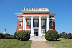
Murray County courthouse in Chatsworth
|
|

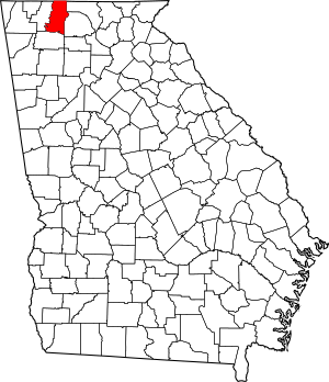
Location within the U.S. state of Georgia
|
|
 Georgia's location within the U.S. |
|
| Country | |
| State | |
| Founded | 1832 |
| Seat | Chatsworth |
| Largest city | Chatsworth |
| Area | |
| • Total | 347 sq mi (900 km2) |
| • Land | 344 sq mi (890 km2) |
| • Water | 2.2 sq mi (6 km2) 0.6%% |
| Population
(2020)
|
|
| • Total | 39,973 |
| • Density | 115.20/sq mi (44.48/km2) |
| Time zone | UTC−5 (Eastern) |
| • Summer (DST) | UTC−4 (EDT) |
| Congressional district | 14th |
Murray County is a county in the northwest part of Georgia, a state in the United States. In 2020, about 39,973 people lived here. The main town and county seat is Chatsworth. Murray County is also part of the larger Dalton and Chattanooga city areas.
Contents
History of Murray County
In December 1832, the government of Georgia created Murray County. It was named after Thomas W. Murray, an important leader from Georgia. At first, the county was very big, covering many areas that are now other counties. Because it was so large, it was later divided into smaller counties.
Eventually, Murray County became about 342 square miles. The first county seat was Spring Place. But when the railroad was built through Chatsworth, it became easier to reach. So, the county seat was moved to Chatsworth.
The Cherokee People
When Murray County was formed, it was in the middle of the Cherokee Nation. White settlers did not move into the county in large numbers until after the Cherokee people were forced to leave in 1838–1839. This sad event is known as the Trail of Tears.
Before this, a Moravian mission was set up in Spring Place in 1801 to help the Cherokee. It even had a post office by 1810, which was one of the oldest in North Georgia. After the Cherokee left, the Moravians moved with them to what is now Oklahoma.
Later, a school called the Brackett Indian School was built on land given by James B. Brackett. The Brackett family was a well-known Cherokee family who lived in the area. Some of them were forced to leave Georgia during the Trail of Tears, but some returned years later.
The Civil War Years
When the American Civil War started, Murray County was not very rich and did not have many factories. When Georgia left the United States, many men and boys from Murray County joined the Confederate Army.
Some of the local army groups included:
- Spring Place Volunteers
- Murray Rifle Company
- Cohutta Rangers
In 1864, there were a few small battles between Union and Confederate soldiers near Spring Place. More fighting happened in 1865. By then, Spring Place was known as a place where Confederate fighters were active. Union soldiers tried to stop this activity in March 1865.
The Railroad Arrives
After two earlier tries, a railroad line was finally built through Murray County in 1906. This new line ran from north to south. Because of the railroad, new towns grew up along the tracks, including Chatsworth.
The railroad made it possible to ship timber (wood) out of the mountains. It also helped with mining. Talc, a soft mineral, was found in the 1870s. With the railroad, talc could be mined and sent all over the country.
Spring Place, the old county seat, was not on the new railroad line. Many people in Murray County wanted to move the county seat to Chatsworth because it was easier to get to. After a vote in 1912, Chatsworth officially became the county seat. It still is today.
For a long time, Murray County was mostly about farming. After World War II, the textile industry (making cloth) started to grow in the county. Today, the carpet industry is the biggest employer in Murray County.
Geography
Murray County covers about 347 square miles. Most of this is land (344 square miles), and a small part is water (2.2 square miles).
Most of the county is in the Conasauga River area. The southeastern part is in the Coosawattee River area. Both of these rivers are part of the larger ACT River Basin.
Main Roads
Neighboring Counties
- Polk County, Tennessee (to the northeast)
- Fannin County (to the east-northeast)
- Gilmer County (to the east)
- Gordon County (to the south)
- Whitfield County (to the west)
- Bradley County, Tennessee (to the northwest)
Protected Natural Areas
- Chattahoochee National Forest (part of it is in Murray County)
People of Murray County (Demographics)
Demographics is the study of people in a certain area, like their age, race, and how many live there.
| Historical population | |||
|---|---|---|---|
| Census | Pop. | %± | |
| 1840 | 4,695 | — | |
| 1850 | 14,443 | 207.6% | |
| 1860 | 7,083 | −51.0% | |
| 1870 | 6,500 | −8.2% | |
| 1880 | 8,269 | 27.2% | |
| 1890 | 8,461 | 2.3% | |
| 1900 | 8,623 | 1.9% | |
| 1910 | 9,763 | 13.2% | |
| 1920 | 9,490 | −2.8% | |
| 1930 | 9,215 | −2.9% | |
| 1940 | 11,137 | 20.9% | |
| 1950 | 10,676 | −4.1% | |
| 1960 | 10,447 | −2.1% | |
| 1970 | 12,986 | 24.3% | |
| 1980 | 19,685 | 51.6% | |
| 1990 | 26,147 | 32.8% | |
| 2000 | 36,506 | 39.6% | |
| 2010 | 39,628 | 8.6% | |
| 2020 | 39,973 | 0.9% | |
| 2023 (est.) | 41,035 | 3.6% | |
| U.S. Decennial Census 1790-1880 1890-1910 1920-1930 1930-1940 1940-1950 1960-1980 1980-2000 2010 2020 |
|||
What the 2020 Census Shows
In 2020, there were 39,973 people living in Murray County. There were 14,385 households (groups of people living together) and 10,557 families.
| Race / Ethnicity (NH = Non-Hispanic) | Pop 2000 | Pop 2010 | Pop 2020 | % 2000 | % 2010 | % 2020 |
|---|---|---|---|---|---|---|
| White alone (NH) | 33,890 | 33,666 | 32,164 | 92.83% | 84.96% | 80.46% |
| Black or African American alone (NH) | 191 | 212 | 263 | 0.52% | 0.53% | 0.66% |
| Native American or Alaska Native alone (NH) | 94 | 94 | 79 | 0.26% | 0.24% | 0.20% |
| Asian alone (NH) | 89 | 110 | 127 | 0.24% | 0.28% | 0.32% |
| Pacific Islander alone (NH) | 4 | 1 | 2 | 0.01% | 0.00% | 0.01% |
| Other race alone (NH) | 3 | 15 | 58 | 0.01% | 0.04% | 0.15% |
| Mixed race or Multiracial (NH) | 229 | 376 | 1,366 | 0.63% | 0.95% | 3.42% |
| Hispanic or Latino (any race) | 2,006 | 5,154 | 5,914 | 5.49% | 13.01% | 14.79% |
| Total | 36,506 | 39,628 | 39,973 | 100.00% | 100.00% | 100.00% |
What the 2010 Census Showed
In 2010, there were 39,628 people living in Murray County. About 89.1% of the people were white. About 13.0% of the population was of Hispanic or Latino background.
The average household had 2.80 people, and the average family had 3.20 people. The median age (middle age) was 36.2 years.
The median income for a household was $38,226. This means half of the households earned more than this, and half earned less. About 17.1% of the people in the county lived below the poverty line.
Fun Places to Visit (Attractions)

Murray County has several interesting places to visit:
- Chief Vann House Historic Site in Spring Place: This two-story red brick house was built in 1805 for James Vann, a Cherokee chief. It was located along the Federal Road, an important early path in northwest Georgia.
- Fort Mountain State Park: This large park covers 3,712 acres in the Cohutta Mountains. It offers great views and outdoor activities.
- Chattahoochee National Forest: A big part of this forest is in northeastern Murray County. Inside the forest is the Cohutta Wilderness Area, a wild, mountainous place with popular trails for backpacking.
- Carters Lake: This lake was formed by the Carter Dam, which is the largest earth-rock dam east of the Mississippi River. The 3,200-acre lake is a popular spot for fishing, boating, and camping.
- Lake Conasauga: Located near the top of Grassy Mountain, this lake was built in 1940. It is the highest lake in Georgia, sitting 3,150 feet above sea level.
Communities
Cities
- Chatsworth (This is the county seat, where the main government offices are.)
Towns
Unincorporated Communities
These are smaller communities that are not officially cities or towns.
- Spring Place
- Carters
- Tennga
- Cisco: This community is located where U.S. Route 411, Georgia State Route 2, and Georgia State Route 61 meet. It's about 13 miles north of Chatsworth. Cisco has a post office. The name "Cisco" comes from "Cis" Cockburn, a local store owner.
- Crandall: This community is also along U.S. Route 411, Georgia State Route 2, and Georgia State Route 61, about 7 miles north of Chatsworth. Crandall also has a post office. It used to be an incorporated town until 1995.
- Amzi/Treadwell Community
- Dennis: A post office was in Dennis from 1882 to 1906. The community was named after Dennis Johnson, a local merchant.
- Hasslers Mill: This community had a post office from 1836 to 1909. It was named after William Hassler.
- Holley: This community was also known as "Holly." It had a post office called Holly Creek starting in 1843, which later changed to Holly in 1894 and closed in 1909. The name comes from nearby Holly Creek.
- Ramhurst: This community is located where U.S. Route 411 and U.S. Route 76 meet, about 5.2 miles south-southeast of Chatsworth. It was first called "Ramsey" after A. K. Ramsey, who owned a local mill and store.
- Sumac: This community gets its name from nearby Sumac Creek. It had a post office from 1878 to 1907. The town was hit by a tornado on April 12, 2020, which caused significant damage.
Media
Murray County, Georgia, has been featured in a TV series called "Independent Lens" that talked about bullying.
See also
 In Spanish: Condado de Murray (Georgia) para niños
 | Claudette Colvin |
 | Myrlie Evers-Williams |
 | Alberta Odell Jones |

