
Whitfield County, Georgia facts for kids
Quick facts for kids
Whitfield County
|
|||
|---|---|---|---|
_in_October_2013.jpg)
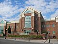
Whitfield County Courthouse in October 2013
|
|||
|
|||

Location within the U.S. state of Georgia
|
|||
 Georgia's location within the U.S. |
|||
| Country | |||
| State | |||
| Founded | December 30, 1851 | ||
| Named for | George Whitefield | ||
| Seat | Dalton | ||
| Largest city | Dalton | ||
| Area | |||
| • Total | 291 sq mi (750 km2) | ||
| • Land | 290. sq mi (751 km2) | ||
| • Water | 0.6 sq mi (2 km2) 0.2%% | ||
| Population
(2020)
|
|||
| • Total | 102,864 | ||
| • Density | 355/sq mi (137/km2) | ||
| Time zone | UTC−5 (Eastern) | ||
| • Summer (DST) | UTC−4 (EDT) | ||
| Congressional district | 14th | ||


Whitfield County is a special area in the U.S. state of Georgia. It is located in the beautiful Northwest part of the state.
In 2020, about 102,864 people lived here. The main town, or county seat, is Dalton. Whitfield County was created a long time ago, on December 30, 1851. It was named after George Whitefield, who was a famous speaker. The "e" was left out of the name to match how his name was said.
Whitfield County is part of the larger Dalton metropolitan area, Georgia. This area also connects to the Chattanooga–Cleveland–Dalton combined statistical area.
Contents
Exploring Whitfield County's Geography
Whitfield County covers about 291 square miles. Most of this area, about 290 square miles, is land. Only a small part, 0.6 square miles, is water.
Most of the county is in the Conasauga River area. This river basin is part of the larger Coosa-Tallapoosa River Basin. A small part on the western side is in the Middle Tennessee-Chickamauga area. There's also a tiny bit in the south that's part of the Oostanaula River area.
Neighboring Counties and States
Whitfield County shares its borders with several other counties and even another state.
- Bradley County, Tennessee (to the north)
- Murray County (to the east)
- Gordon County (to the south)
- Walker County (to the west-southwest)
- Catoosa County (to the west-northwest)
- Hamilton County, Tennessee (to the northwest)
Protected Natural Areas
A part of the beautiful Chattahoochee National Forest is located within Whitfield County. This is a special place where nature is protected.
Getting Around Whitfield County
There are many important roads and paths that help people travel through Whitfield County.
Main Roads and Highways
 Interstate 75
 U.S. Route 41
 U.S. Route 76
 State Route 2
 State Route 3
 State Route 3 Connector
 State Route 52
 State Route 71
 State Route 201
 State Route 286
 State Route 401 (this is another name for I-75)
Paths for Walking and Biking
- Pinhoti Trail
People of Whitfield County
The number of people living in Whitfield County has grown a lot over the years.
| Historical population | |||
|---|---|---|---|
| Census | Pop. | %± | |
| 1860 | 10,047 | — | |
| 1870 | 10,117 | 0.7% | |
| 1880 | 11,900 | 17.6% | |
| 1890 | 12,916 | 8.5% | |
| 1900 | 14,509 | 12.3% | |
| 1910 | 15,934 | 9.8% | |
| 1920 | 16,897 | 6.0% | |
| 1930 | 20,808 | 23.1% | |
| 1940 | 26,105 | 25.5% | |
| 1950 | 34,432 | 31.9% | |
| 1960 | 42,109 | 22.3% | |
| 1970 | 55,108 | 30.9% | |
| 1980 | 65,789 | 19.4% | |
| 1990 | 72,462 | 10.1% | |
| 2000 | 83,525 | 15.3% | |
| 2010 | 102,599 | 22.8% | |
| 2020 | 102,864 | 0.3% | |
| 2023 (est.) | 103,687 | 1.1% | |
| U.S. Decennial Census 1790-1880 1890-1910 1920-1930 1930-1940 1940-1950 1960-1980 1980-2000 2010 2020 |
|||
How Many People Live Here? (2020)
In 2020, there were 102,864 people living in Whitfield County. There were 34,518 households, which are groups of people living together. Also, there were 25,351 families.
A Look at the Population in 2010
Back in 2010, there were 102,599 people in the county. About 35,180 households and 26,090 families lived here. The county had about 353 people per square mile.
Many different groups of people live in Whitfield County. In 2010, about 76.6% of people were white. About 3.7% were Black or African American, and 1.3% were Asian. People of Hispanic or Latino origin made up 31.6% of the population.
The average age of people in the county was 34 years old. Many households (41.4%) had children under 18 living with them.
The average income for a household was about $42,345. For families, it was around $48,991.
Learning in Whitfield County
Whitfield County has many schools for students of all ages.
Whitfield County Schools
This school district serves many students in the county.
High Schools
- Northwest Whitfield High School
- Southeast Whitfield High School
- Coahulla Creek High School
Middle Schools
- Eastbrook Middle School
- New Hope Middle School
- North Whitfield Middle School
- Valley Point Middle School
- Westside Middle School
Elementary Schools
- Antioch Elementary School
- Beaverdale Elementary School
- Cedar Ridge Elementary School
- Cohutta Elementary School
- Dawnville Elementary School
- Dug Gap Elementary School
- Eastside Elementary School
- New Hope Elementary School
- Pleasant Grove Elementary School
- Tunnel Hill Elementary School
- Valley Point Elementary School
- Varnell Elementary School
- Westside Elementary School
Other Schools
- Crossroads Academy
- Phoenix High School
Dalton Public Schools
This school district serves the city of Dalton.
High Schools
- Dalton High School
- Morris Innovative High School
Middle Schools
- Dalton Middle School
Elementary Schools
- Brookwood Elementary
- Blue Ridge Elementary
- City Park Elementary
- Park Creek Elementary
- Roan Elementary
- Westwood Elementary
Private Schools
There are also private schools in the county.
- Cedar Valley Christian Academy
- Christian Heritage School
- Learning Tree School
Towns and Communities
Whitfield County has several cities, towns, and smaller communities.
Cities
Towns
Unincorporated Communities
These are smaller places that are not officially cities or towns.
- Rocky Face
- Dawnville
- Tilton
Images for kids
-
The Whitfield County Courthouse in Dalton.
See also
 In Spanish: Condado de Whitfield para niños
