
Tunnel Hill, Georgia facts for kids
Quick facts for kids
Tunnel Hill, Georgia
|
|
|---|---|

City hall
|
|

Location in Whitfield County and the state of Georgia
|
|
| Country | United States |
| State | Georgia |
| County | Whitfield, Catoosa |
| Area | |
| • Total | 1.98 sq mi (5.13 km2) |
| • Land | 1.97 sq mi (5.11 km2) |
| • Water | 0.01 sq mi (0.02 km2) |
| Elevation | 840 ft (256 m) |
| Population
(2020)
|
|
| • Total | 963 |
| • Density | 488.09/sq mi (188.48/km2) |
| Time zone | UTC-5 (Eastern (EST)) |
| • Summer (DST) | UTC-4 (EDT) |
| ZIP code |
30755
|
| Area code(s) | 706/762 |
| FIPS code | 13-77736 |
| GNIS feature ID | 0333273 |
Tunnel Hill is a small city in northwest Georgia, United States. It is located in Whitfield County and Catoosa County. The city is part of the Dalton area. In 2020, about 963 people lived there. The city gets its name from the Chetoogeta Mountain Tunnel, a long railroad tunnel built in the 1840s.
Contents
History of Tunnel Hill
Early Beginnings and Name Change
The area was first called Doe Run. It became an official town on March 4, 1848, and was named Tunnelsville. Later, in 1856, its name changed to Tunnel Hill. Both names come from the nearby Chetoogeta Mountain Tunnel. This tunnel is 1,497 feet (456 meters) long. It was built through Chetoogeta Mountain for the Western & Atlantic Railroad. The tunnel was officially opened on October 31, 1849.
Tunnel Hill During the Civil War
During the American Civil War, the homes in Tunnel Hill were used as a large hospital system. This helped many soldiers who were hurt. The Clisby Austin House was an important building. It was the headquarters for Union General William T. Sherman. He planned his attacks against nearby Dalton and Resaca from this house. These attacks were the start of the Atlanta Campaign. Many battles and army camps were in this area during the war. Today, people remember these events with an annual battle reenactment in September.
The actual battles happened on these dates:
- September 11, 1863
- February 23, 24-25, 1864
- May 5–7, 1864
- March 3, 1865
Geography and Location

Tunnel Hill is located at coordinates 34°50′45″N 85°2′35″W. The city is in a hilly area at the base of Chetoogeta Mountain. This mountain is also called "Tunnel Hill Ridge" on maps. A special line called the Tennessee Valley Divide runs along the top of the ridge. This line separates the water that flows into the Tennessee River from the water that flows into the Conasauga River.
Roads and Connections
U.S. Route 41 connects Tunnel Hill to Ringgold to the northwest. It also connects to Dalton to the southeast. Georgia State Route 201 links the town with Varnell to the northeast. The city covers about 1.5 square miles (3.9 square kilometers) of land.
Population and People
| Historical population | |||
|---|---|---|---|
| Census | Pop. | %± | |
| 1880 | 258 | — | |
| 1890 | 360 | 39.5% | |
| 1900 | 302 | −16.1% | |
| 1910 | 295 | −2.3% | |
| 1920 | 208 | −29.5% | |
| 1930 | 211 | 1.4% | |
| 1970 | 1,146 | — | |
| 1980 | 936 | −18.3% | |
| 1990 | 970 | 3.6% | |
| 2000 | 1,209 | 24.6% | |
| 2010 | 856 | −29.2% | |
| 2020 | 963 | 12.5% | |
| U.S. Decennial Census | |||
In 2010, Tunnel Hill had 856 people. Most of the people living there were white (93.5%). There were also smaller groups of African American (3.7%), Native American (0.7%), and Asian (0.2%) residents. About 3.5% of the population was Hispanic or Latino.
In 2000, there were 1,209 people living in Tunnel Hill. There were 451 households, which are groups of people living together. About 35% of these households had children under 18 years old. The average household had 2.68 people. The average family had 3.00 people.
The population was spread out by age. About 24.8% of people were under 18. About 12.9% were 65 years or older. The average age in the city was 37 years old. For every 100 females, there were about 101.8 males.
Images for kids
-
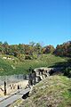
The northwest sides of the old Western and Atlantic Railroad Tunnel (right) and the newer CSX (left) railroad tunnels.
-
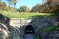
The stone entrance of the old W&A tunnel, which is now a walking path.
-
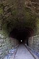
Inside the brick-lined W&A tunnel, now a walking path, looking southeast.


See also
 In Spanish: Tunnel Hill para niños
