Morganton, Georgia facts for kids
Quick facts for kids
Morganton, Georgia
|
||
|---|---|---|

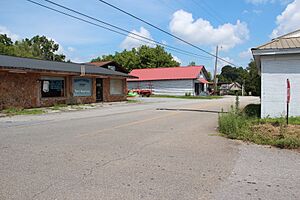
Downtown Morganton
|
||
|
||

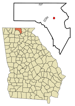
Location in Fannin County and the state of Georgia
|
||
| Country | United States | |
| State | Georgia | |
| County | Fannin | |
| Area | ||
| • Total | 0.79 sq mi (2.05 km2) | |
| • Land | 0.78 sq mi (2.03 km2) | |
| • Water | 0.01 sq mi (0.02 km2) | |
| Elevation | 1,778 ft (542 m) | |
| Population
(2020)
|
||
| • Total | 285 | |
| • Density | 363.52/sq mi (140.40/km2) | |
| Time zone | UTC-5 (Eastern (EST)) | |
| • Summer (DST) | UTC-4 (EDT) | |
| ZIP code |
30560
|
|
| Area code(s) | 706/762 | |
| FIPS code | 13-52724 | |
| GNIS feature ID | 0328842 | |
| Website | https://cityofmorgantonga.gov/ | |
Morganton is a small city located in Fannin County, in the state of Georgia, United States. In 2020, about 285 people lived there.
Contents
Morganton's Past: A Look at Its History
Before European colonization (when people from Europe started settling in America), the area where Morganton is now was home to the Cherokee people. They, along with other Indigenous peoples (native groups), lived there for thousands of years.
In 1856, the Georgia General Assembly (Georgia's law-making group) officially made Morganton a city. The city got its name from another town called Morganton, North Carolina.
Morganton was once the most important town in Fannin County. It served as the county seat (the main town where the county government is located) from 1854 until 1895. After that, the county seat moved to Blue Ridge.
Where is Morganton? Exploring Its Geography
Morganton is in the eastern part of Fannin County. You can find it at these coordinates: 34°52′36″N 84°14′44″W / 34.87667°N 84.24556°W. It sits on the northeast side of Blue Ridge Reservoir.
Georgia State Route 60 goes right through the city. This road leads about 1.5 miles (2.4 km) northwest to U.S. Route 76. If you go southeast on SR 60, it's about 26 miles (42 km) to Suches.
To get to Blue Ridge, which is the current county seat, you can travel about 6 miles (9.7 km) west using SR 60 and old US 76.
The United States Census Bureau says that Morganton covers a total area of about 0.79 square miles (2.05 square kilometers). Only a tiny part of this area, about 0.01 square miles (0.02 square kilometers), is water.
Who Lives in Morganton? Population Facts
The city's population has changed over the years. Here's how many people have lived in Morganton during different census (official counts of the population) years:
| Historical population | |||
|---|---|---|---|
| Census | Pop. | %± | |
| 1880 | 143 | — | |
| 1890 | 170 | 18.9% | |
| 1910 | 195 | — | |
| 1920 | 171 | −12.3% | |
| 1930 | 271 | 58.5% | |
| 1940 | 285 | 5.2% | |
| 1950 | 244 | −14.4% | |
| 1960 | 211 | −13.5% | |
| 1970 | 205 | −2.8% | |
| 1980 | 263 | 28.3% | |
| 1990 | 295 | 12.2% | |
| 2000 | 299 | 1.4% | |
| 2010 | 303 | 1.3% | |
| 2020 | 285 | −5.9% | |
| U.S. Decennial Census | |||
Population Details from Recent Years
In 2010, there were 303 people living in Morganton. Most of the people (98.7%) were White. A small number (0.3%) were from other races, and 0.7% were from two or more races. About 0.3% of the population was Hispanic or Latino.
Looking back at the 2000 census, there were 299 people in Morganton. These people lived in 121 households (groups of people living together) and 87 family units.
The average age of people in Morganton in 2000 was 43 years old. About 23.1% of the population was under 18. Also, 19.1% of the people were 65 years or older.
The average yearly income for a household in Morganton in 2000 was $12,500. For families, the average income was $15,836. The per capita income (average income per person) was $13,897.
About 26.8% of all the people in Morganton lived below the poverty line (meaning they had very low incomes). This included 48.0% of children under 18 and 31.8% of people aged 65 or older.
See also
 In Spanish: Morganton (Georgia) para niños
 | Dorothy Vaughan |
 | Charles Henry Turner |
 | Hildrus Poindexter |
 | Henry Cecil McBay |


