Union County, Georgia facts for kids
Quick facts for kids
Union County
|
||
|---|---|---|

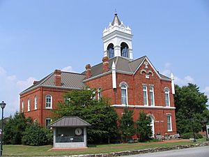
Old Union County Courthouse in Blairsville
|
||
|
||

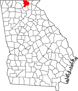
Location within the U.S. state of Georgia
|
||
 Georgia's location within the U.S. |
||
| Country | ||
| State | ||
| Founded | December 3, 1832 | |
| Seat | Blairsville | |
| Largest city | Blairsville | |
| Area | ||
| • Total | 329 sq mi (850 km2) | |
| • Land | 322 sq mi (830 km2) | |
| • Water | 7.1 sq mi (18 km2) 2.2% | |
| Population
(2020)
|
||
| • Total | 24,632 | |
| • Density | 76/sq mi (29/km2) | |
| Time zone | UTC−5 (Eastern) | |
| • Summer (DST) | UTC−4 (EDT) | |
| Congressional district | 9th | |
Union County is a county located in the northeast part of Georgia. As of the 2020 census, about 24,632 people lived there. The main town and county seat is Blairsville.
Contents
History
Union County was once a key part of the Cherokee tribe's home. This area was mountainous and hard to reach. In the 1820s, gold was found here. This made white settlers want to move in.
The gold rush did not last very long. But a system called a land lottery opened the area for settlement. Union County was created in 1832. It was made from a part of Cherokee County.
Newcomers formed groups to make the Cherokee leave their land. This was part of a larger event. Many Native American tribes were forced to move west. This event is known as the Trail of Tears. The Cherokee were moved between 1836 and 1839. About 1,600 of their enslaved people also moved. They were forced to go to what is now Oklahoma. About 4,000 Cherokee people died during this journey.
The "Union Party" was a political group. They supported moving the Native Americans. They wanted to open the land for white settlers. This is likely how the county got its name.
Later, parts of Union County were given to other counties. In 1854, part went to Fannin County. In 1856, parts went to Gilmer County and Towns County. Many early white settlers came from Virginia or North Carolina. They used old frontier roads to get here.
Union County was a mountainous area. It was not good for large farms with many enslaved people. So, it had fewer enslaved people than other parts of Georgia. In 1850, only 61 slave owners were listed. They owned a total of 278 enslaved people.
Before the American Civil War, many white people in Union County supported the "Union." They did not like the rich plantation owners in other parts of Georgia. This was true for much of Georgia's northern mountains.
When Georgia left the United States, most people in Union County supported the Confederacy. Most soldiers from the county fought for the Confederacy. Some joined willingly. Others were drafted after 1862.
Joseph E. Brown was the governor of Georgia during the war. He lived in Union County. He strongly supported leaving the Union. He also defended slavery. Brown was a bit controversial. He was from north Georgia. The plantation owners never fully accepted him. But he was popular with common white Georgians. He often spoke up for them. Brown did not like the Confederate draft. He felt the central Confederate government was taking too much power.
Even with general support for the Confederacy, some people in Union County still supported the Union. Union County was one of the few Georgia counties to send men to fight for the Union Army. Six men from Company A of the 1st Georgia Infantry Battalion (Union) were killed.
After the war, new railroad lines were built. These connected Union County to other areas. This helped farmers sell their goods more easily. The first paved road in Union County was finished in 1926. It went from Cleveland to the North Carolina border.
Tourism grew when the government bought 31,000 acres of forest. This land was in Union and nearby counties. In 1937, they created the Chattahoochee National Forest.
Geography
Union County covers about 329 square miles. About 322 square miles are land. The rest, about 7.1 square miles, is water.
Brasstown Bald is Georgia's highest mountain. It is located in southeast Union County. It sits on the border with Towns County.
The central and northern parts of Union County are in the Hiwassee River area. This river flows into the Middle Tennessee-Hiwassee basin. The southwestern part is in the Ocoee River area. A small part of the southeast corner is in the Upper Chattahoochee River area. This is also where the Chattahoochee River begins. The Appalachian Trail also goes through southern Union County.
Adjacent counties
- Cherokee County, North Carolina (north)
- Clay County, North Carolina (northeast)
- Towns County (east)
- White County (southeast)
- Lumpkin County (south)
- Fannin County (west)
National protected area
- Appalachian Trail (part)
- Chattahoochee National Forest (part)
Transportation
Major highways
 U.S. Route 19
 U.S. Route 76
 U.S. Route 129
 State Route 2
 State Route 11
 State Route 60
 State Route 180
 State Route 325
 State Route 348
 State Route 515
Other roads
- Blue Ridge Highway (Old US 76/Old SR 2)
- Skeenah Gap Road
- Town Creek School Road
- Mulky Gap Road
- Owltown Road
- Spiva Bridge Way
- Gumlog Road
- Loving Road
- Nottely Dam Road (Old SR 325). Not all of Nottely Dam Road remains a state route.
- Pat Haralson Memorial Drive
- Trackrock Gap Road
Demographics
| Historical population | |||
|---|---|---|---|
| Census | Pop. | %± | |
| 1840 | 3,152 | — | |
| 1850 | 7,234 | 129.5% | |
| 1860 | 4,413 | −39.0% | |
| 1870 | 5,267 | 19.4% | |
| 1880 | 6,431 | 22.1% | |
| 1890 | 7,749 | 20.5% | |
| 1900 | 8,481 | 9.4% | |
| 1910 | 6,918 | −18.4% | |
| 1920 | 6,455 | −6.7% | |
| 1930 | 6,340 | −1.8% | |
| 1940 | 7,680 | 21.1% | |
| 1950 | 7,318 | −4.7% | |
| 1960 | 6,510 | −11.0% | |
| 1970 | 6,811 | 4.6% | |
| 1980 | 9,390 | 37.9% | |
| 1990 | 11,993 | 27.7% | |
| 2000 | 17,289 | 44.2% | |
| 2010 | 21,356 | 23.5% | |
| 2020 | 24,632 | 15.3% | |
| 2023 (est.) | 27,124 | 27.0% | |
| U.S. Decennial Census 1790-1880 1890-1910 1920-1930 1930-1940 1940-1950 1960-1980 1980-2000 2010 |
|||
2020 census
| Race | Num. | Perc. |
|---|---|---|
| White (non-Hispanic) | 22,646 | 91.94% |
| Black or African American (non-Hispanic) | 126 | 0.51% |
| Native American | 74 | 0.3% |
| Asian | 100 | 0.41% |
| Other/Mixed | 870 | 3.53% |
| Hispanic or Latino | 816 | 3.31% |
In 2020, there were 24,632 people living in Union County. There were 9,743 households and 6,957 families.
2010 census
In 2010, the county had 21,356 people. There were 9,116 households and 6,382 families. The population density was about 66 people per square mile. Most people were white (96.8%).
About 22.6% of households had children under 18. Most households (58.8%) were married couples. The average household had 2.30 people. The average family had 2.75 people. The average age of people in the county was 50.7 years.
The average income for a household was $41,298. For a family, it was $50,772. About 9.5% of families lived below the poverty line. This included 14.5% of those under 18.
Media
The North Georgia News is a newspaper. It has been published weekly in Blairsville since 1909. Since 2012, it has been the only newspaper for Union County.
Communities
City
Unincorporated communities
See also
 In Spanish: Condado de Union (Georgia) para niños
 | John T. Biggers |
 | Thomas Blackshear |
 | Mark Bradford |
 | Beverly Buchanan |


