Blairsville, Georgia facts for kids
Quick facts for kids
Blairsville, Georgia
|
||
|---|---|---|

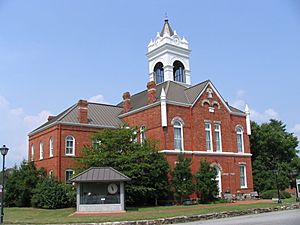
Historic Union County Courthouse
|
||
|
||
| Nickname(s):
City of Mountains
|
||
| Motto(s):
A Place for All Seasons
|
||

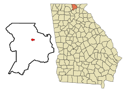
Location in Union County and the state of Georgia
|
||
| Country | United States | |
| State | Georgia | |
| County | Union | |
| Area | ||
| • Total | 1.11 sq mi (2.88 km2) | |
| • Land | 1.11 sq mi (2.86 km2) | |
| • Water | 0.01 sq mi (0.02 km2) | |
| Elevation | 1,893 ft (577 m) | |
| Population
(2020)
|
||
| • Total | 616 | |
| • Density | 556.96/sq mi (215.08/km2) | |
| Time zone | UTC-5 (Eastern (EST)) | |
| • Summer (DST) | UTC-4 (EDT) | |
| ZIP codes |
30512, 30514
|
|
| Area code(s) | 706 | |
| FIPS code | 13-08480 | |
| GNIS feature ID | 2403875 | |
Blairsville is a small city in northern Georgia, United States. It is the main town, or county seat, of Union County. The city was founded near the Nottely River, which was later dammed in 1942. This created Lake Nottely, which is now a popular spot for fun activities. In 2020, about 616 people lived in Blairsville.
Contents
History of Blairsville
Early Days and Gold Discoveries
In the 1830s, the Cherokee people and other Native American tribes were forced to move from their lands in the Southeast. This area along the Nottely River was once part of the large Cherokee territory. A famous Cherokee leader named Goingsnake was born here in 1758.
After American settlers moved in, Blairsville was chosen as the county seat for Union County in 1835. The town was named after James Blair, a soldier who fought in the American Revolutionary War.
While the nearby city of Dahlonega was famous for being the first place where gold was found in the United States, the Blairsville area was known for having the purest gold in northern Georgia. Experts in Washington, D.C., could tell that gold from the Coosa Mines was special because it was "the yellowest gold" they had ever seen!
Modern Development and Lake Nottely
Before World War II, this part of northern Georgia was very rural and quiet. During the Great Depression, a big project called the Tennessee Valley Authority (TVA) began. The Nottely River was chosen for one of these projects. A dam was built to create a reservoir, which is like a large lake. This dam helped generate electricity for the area and also created Lake Nottely, which became a place for people to enjoy outdoor activities. This project brought electricity to many homes in the countryside.
Blairsville also has a long history with its local newspaper, the North Georgia News, which first started publishing in 1909. A large bank called United Community Banks, Inc. was founded in Blairsville in 1949 and has grown to be one of the biggest in the Southeast United States.
Geography and Climate
Highways and Location
Blairsville is located where several main highways meet. U.S. Routes 19 and 76, along with Georgia State Route 515 (also known as Zell Miller Mountain Parkway), pass through the city.
- U.S. 19 goes north about 21 miles (34 km) to Murphy, North Carolina. It goes south about 34 miles (55 km) to Dahlonega.
- U.S. 76 and GA-515 go northeast about 8 miles (13 km) to Young Harris. They go west about 23 miles (37 km) to Blue Ridge.
- Atlanta is about 99 miles (159 km) south of Blairsville via U.S. 19.
The city covers about 1.1 square miles (2.8 square kilometers) of land.
Weather in Blairsville
Blairsville has a humid subtropical climate, which means it usually has warm, humid summers and mild winters. However, because it's located high up in the mountains (about 1,883 feet or 574 meters above sea level), the nights are often cooler than in other parts of the Southeast.
The area gets a good amount of rain, about 56 inches (142 cm) each year. The temperature can change a lot between day and night, especially in spring and fall. Snow usually falls a few times each year, with an average of 4 inches (10 cm) annually.
- The average daily temperature ranges from about 37°F (3°C) in January to 73°F (23°C) in July.
- On average, there are about 7 days a year where the temperature reaches 90°F (32°C) or higher.
- There are about 4 days a year where the temperature stays below freezing (32°F or 0°C) all day.
| Climate data for Blairsville, Georgia (1991–2020 normals, extremes 1931–present) | |||||||||||||
|---|---|---|---|---|---|---|---|---|---|---|---|---|---|
| Month | Jan | Feb | Mar | Apr | May | Jun | Jul | Aug | Sep | Oct | Nov | Dec | Year |
| Record high °F (°C) | 76 (24) |
76 (24) |
89 (32) |
89 (32) |
94 (34) |
100 (38) |
100 (38) |
98 (37) |
95 (35) |
91 (33) |
83 (28) |
74 (23) |
100 (38) |
| Mean daily maximum °F (°C) | 49.4 (9.7) |
53.2 (11.8) |
60.3 (15.7) |
69.2 (20.7) |
76.1 (24.5) |
81.9 (27.7) |
84.8 (29.3) |
84.1 (28.9) |
79.5 (26.4) |
70.4 (21.3) |
60.7 (15.9) |
52.5 (11.4) |
68.5 (20.3) |
| Daily mean °F (°C) | 37.4 (3.0) |
40.5 (4.7) |
47.1 (8.4) |
55.0 (12.8) |
63.0 (17.2) |
70.2 (21.2) |
73.5 (23.1) |
72.6 (22.6) |
67.2 (19.6) |
56.7 (13.7) |
47.0 (8.3) |
40.6 (4.8) |
55.9 (13.3) |
| Mean daily minimum °F (°C) | 25.4 (−3.7) |
27.7 (−2.4) |
33.9 (1.1) |
40.9 (4.9) |
50.0 (10.0) |
58.5 (14.7) |
62.1 (16.7) |
61.1 (16.2) |
54.9 (12.7) |
42.9 (6.1) |
33.3 (0.7) |
28.7 (−1.8) |
43.3 (6.3) |
| Record low °F (°C) | −16 (−27) |
−8 (−22) |
−5 (−21) |
16 (−9) |
23 (−5) |
34 (1) |
40 (4) |
42 (6) |
26 (−3) |
14 (−10) |
0 (−18) |
−9 (−23) |
−16 (−27) |
| Average precipitation inches (mm) | 5.85 (149) |
4.76 (121) |
5.56 (141) |
5.15 (131) |
4.49 (114) |
5.57 (141) |
4.88 (124) |
5.27 (134) |
4.42 (112) |
4.21 (107) |
4.68 (119) |
5.46 (139) |
60.30 (1,532) |
| Average snowfall inches (cm) | 0.5 (1.3) |
0.4 (1.0) |
1.0 (2.5) |
0.0 (0.0) |
0.0 (0.0) |
0.0 (0.0) |
0.0 (0.0) |
0.0 (0.0) |
0.0 (0.0) |
0.0 (0.0) |
0.0 (0.0) |
1.2 (3.0) |
3.1 (7.9) |
| Average precipitation days (≥ 0.01 in) | 12.3 | 12.1 | 12.6 | 11.3 | 11.8 | 13.7 | 12.9 | 12.1 | 9.8 | 9.0 | 9.8 | 12.2 | 139.6 |
| Average snowy days (≥ 0.1 in) | 0.2 | 0.2 | 0.2 | 0.0 | 0.0 | 0.0 | 0.0 | 0.0 | 0.0 | 0.0 | 0.0 | 0.4 | 1.0 |
| Source: NOAA | |||||||||||||
Fun Things to Do in Blairsville
Annual Festivals and Events
Blairsville hosts several exciting events each year that celebrate local culture and traditions:
- The Sorghum Festival: Held every year on the second and third weekends in October. This festival celebrates the harvest of sorghum, a plant used to make syrup. You can enjoy rural mountain culture, including bluegrass music and clogging (a type of folk dance).
- The Spring Arts and Crafts Festival: This event takes place every year during the last weekend in May. Artists from all over North Georgia, as well as local artists, restaurants, and businesses, participate. It's held on the historic town square and offers activities for children and live music.
- The Green Bean Festival: Held annually on the last weekend in July. This unique festival features fun contests like green bean pizza eating and canning. There's also a green bean recipe contest, a tractor parade, fresh produce, crafts, and many activities for kids.
Places to Visit and Explore
Blairsville is surrounded by beautiful natural areas and offers many attractions:
- Lake Nottely: This large lake was created by damming the Nottely River. Besides helping to make electricity, it's a great place for recreation. You can go boating, fishing, and enjoy other water activities.
- Appalachian Trail: Part of this famous hiking trail runs through Georgia, including areas near Blairsville. It stretches about 75 miles (121 km) through the Chattahoochee National Forest. The trail has many steep climbs and beautiful views, with elevations from about 2,500 to 4,500 feet (762 to 1,372 meters).
- Butternut Creek Golf Course: If you enjoy golf, this 18-hole public golf course is located right within the city limits, offering a scenic mountainside experience.
- Chattahoochee National Forest: This huge forest covers almost two-thirds of Union County. It has many winding trails where visitors can hike through scenic mountains, by rushing rivers, and past beautiful waterfalls.
- Brasstown Bald: This is the highest mountain peak in Georgia! It has a park with a picnic area and a small observation tower near the top. You can watch a movie there about the changing seasons and how pollution affects the mountain. You can reach the peak by bus or by walking part of the way.
- Vogel State Park: Located about 11 miles (18 km) south of Blairsville, this park is centered around Lake Trahlyta.
- The park offers:
- About 5 miles (8 km) of hiking trails.
- Access to the Appalachian Trail.
- Paddleboat rentals and fishing.
- A miniature golf course.
- Rental cabins and campsites.
- The park also has special seasonal programs like a Fall Festival, Pioneer Christmas, Kids Fishing Rodeo, and summer music events.
Education in Blairsville
Local Schools
The public schools in Blairsville are managed by the Union County School District. It's a smaller school district that oversees five schools:
- Union County Elementary School
- Union County Primary School
- Union County Middle School
- Union County High School
- Woody Gap High/Elementary School
The district has about 172 full-time teachers and teaches over 2,598 students from pre-school all the way to twelfth grade. There is also an alternative evening school called the Mountain Education Center High School. Union County schools are known for their quality and dedication to students.
Colleges and Libraries
Blairsville is close to several colleges:
- North Georgia Technical College has a campus right in town.
- Young Harris College is nearby in Young Harris.
- The University of North Georgia is located in Dahlonega.
The Union County Public Library is part of the Mountain Regional Library System. This system manages four libraries in the area and is connected to Georgia Library PINES, a network that helps people access books and information across the state.
There are also some private schools in nearby towns:
- The Mountain Area Christian Academy in Morganton, Georgia.
- Eastgate Life Academy in Hiawassee, Georgia.
- Murphy Adventist Christian School in Murphy, North Carolina.
Notable People
- Jonathan Davenport - A famous driver in Dirt Super Late Model and NASCAR Cup Series racing.
Transportation
Blairsville has good transportation links:
- Highways: U.S. Route 76 and Zell Miller Mountain Parkway (GA 515) are the main highways. U.S. Routes 19 and 129 also pass through the city.
- Airport: The Blairsville Airport (KDZJ) is located in the city, making it easier for people to travel by air.
Media
The Blairsville area has several ways to get local news and entertainment:
- Newspaper: The North Georgia News is the main newspaper for the area. It's the only official news outlet in Blairsville and is a member of the Georgia Press Association.
- Magazines: Montefino Magazine is a local publication that covers lifestyle and social news for Blairsville and the surrounding areas.
- Radio Stations: Blairsville has 12 local radio stations that play different types of music, sports, news, and talk shows. WUCG-FM 93.1 is based right in Blairsville. Other stations are based in nearby towns like Dahlonega, Murphy, Young Harris, Helen, Hiawassee, and Blue Ridge.
- Television: The local television station is W50AB (channel 50), which is based in Hiawassee.
See also
 In Spanish: Blairsville (Georgia) para niños
 | Emma Amos |
 | Edward Mitchell Bannister |
 | Larry D. Alexander |
 | Ernie Barnes |


