Cherokee County, North Carolina facts for kids
Quick facts for kids
Cherokee County
|
||
|---|---|---|
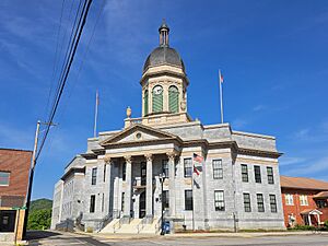
Cherokee County Courthouse in Murphy
|
||
|
||
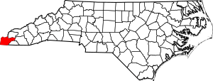
Location within the U.S. state of North Carolina
|
||
 North Carolina's location within the U.S. |
||
| Country | ||
| State | ||
| Founded | 1839 | |
| Named for | Cherokee Indians | |
| Seat | Murphy | |
| Largest community | Andrews | |
| Area | ||
| • Total | 466.67 sq mi (1,208.7 km2) | |
| • Land | 455.54 sq mi (1,179.8 km2) | |
| • Water | 11.13 sq mi (28.8 km2) 2.38% | |
| Population
(2020)
|
||
| • Total | 28,774 | |
| • Estimate
(2023)
|
29,959 | |
| • Density | 63.16/sq mi (24.39/km2) | |
| Demonym(s) | Cherokee Countians | |
| Time zone | UTC−5 (Eastern) | |
| • Summer (DST) | UTC−4 (EDT) | |
| Congressional district | 11th | |
Cherokee County is the westernmost county in the state of North Carolina. It shares borders with Tennessee to the west and Georgia to the south. In 2020, about 28,774 people lived here. The main town and county seat is Murphy.
Contents
History of Cherokee County
This area was home to indigenous peoples for thousands of years. It was part of the large homeland of the historic Cherokee people. Their territory included parts of what are now Virginia, North Carolina, South Carolina, Tennessee, and Georgia.
Early Explorers and Settlers
A Spanish explorer named Hernando DeSoto visited this area in 1540. The first highway, the Unicoi Turnpike, was built in 1813. It connected East Tennessee, North Georgia, and Western North Carolina. Early European settlers began to arrive. Some married Native Americans and received land in 1817. A Baptist mission opened in 1820. A trading post was set up near what is now Murphy before 1828.
The Old Tatham House, built in 1833, is the oldest building still standing in the county. Fort Butler was built near Murphy in 1836. Cherokee County was officially formed in 1839. It was named after the Cherokee Native Americans. The first brick courthouse was built in Murphy in 1844. Murphy became the county seat in 1851.
Growth and Changes
The first industry in Cherokee County was a tannery, started in 1852. As more people moved in, new counties were created. In 1861, part of Cherokee County became Clay County. In 1872, another part became Graham County.
Harshaw Chapel, built in 1869, is the oldest brick church in the county. In the late 1800s, people became very interested in Native American cultures. Some explorers dug up ancient mounds to find artifacts for museums.
The railroad arrived in Cherokee County in 1887. It connected the county to Marietta. The train reached Murphy in 1888. The county's newspaper, the Cherokee Scout, started in 1889.
20th Century to Today
The Cherokee County Jail was built in Murphy in 1922. The current Cherokee County Courthouse was built next door in 1926.
The John C. Campbell Folk School, a famous folk school, opened in 1925. It teaches traditional arts, music, and dance. The first hospital, Petrie Hospital, opened in 1933. Today, Erlanger Western Carolina Hospital is the only hospital in the area.
In the late 1930s, the Hiwassee Dam was built. It created Hiwassee Lake. This dam was the tallest in the world when it was finished in 1940. Another dam, Apalachia, was built in 1942.
In the early 1940s, Fields of the Wood, a religious park, opened. It features the world's largest Christian cross. Tri-County Community College was founded in 1964. The county's animal shelter, Valley River Humane Society, opened in 1969.
Cherokee County has experienced some strong storms. An F4 tornado hit in 1974, causing damage and injuries. Other tornadoes have also affected the area, including one in 2012 and another in 2024.
Tourism is now a big part of the county's economy. Many people visit the area each year.
Geography of Cherokee County
Cherokee County covers about 466 square miles. Most of this is land, with about 11 square miles of water.
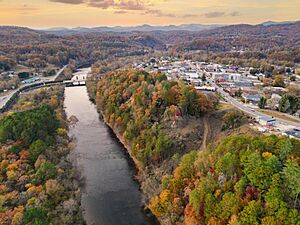
The county is located in the southern Appalachian Mountains. Parts of the Nantahala National Forest are within its borders. The Hiwassee River flows through the county. It eventually joins the Tennessee River. Both rivers were important to the historic Cherokee towns.
Cherokee Reserve Land
Some parts of the Qualla Boundary are in Cherokee County. This land belongs to the Eastern Band of Cherokee Indians. It is protected by their Tribal Police. A tribal casino, Harrah's Cherokee, opened in Murphy in 2015.
Protected Natural Areas
- Nantahala National Forest (part)
Lakes and Rivers
- Appalachia Lake
- Hiwassee Lake
- Hiwassee River
- Nottely River
- Valley River
Neighboring Counties
- Graham County – north
- Clay County – east
- Macon County – east
- Fannin County, Georgia – southwest
- Union County, Georgia – south
- Polk County, Tennessee – west
- Monroe County, Tennessee – northwest
Main Roads
 US 19
US 19 US 64
US 64 US 74
US 74 US 129
US 64 is a long highway that crosses North Carolina. US 74 is a major four-lane highway. It connects cities like Chattanooga and Charlotte. US 19 and US 129 also pass through the county. They link to Atlanta and Knoxville.
Transportation Hubs
- Western Carolina Regional Airport
People of Cherokee County
| Historical population | |||
|---|---|---|---|
| Census | Pop. | %± | |
| 1840 | 3,427 | — | |
| 1850 | 6,838 | 99.5% | |
| 1860 | 9,166 | 34.0% | |
| 1870 | 8,080 | −11.8% | |
| 1880 | 8,182 | 1.3% | |
| 1890 | 9,976 | 21.9% | |
| 1900 | 11,860 | 18.9% | |
| 1910 | 14,136 | 19.2% | |
| 1920 | 15,242 | 7.8% | |
| 1930 | 16,151 | 6.0% | |
| 1940 | 18,813 | 16.5% | |
| 1950 | 18,294 | −2.8% | |
| 1960 | 16,335 | −10.7% | |
| 1970 | 16,330 | 0.0% | |
| 1980 | 18,933 | 15.9% | |
| 1990 | 20,170 | 6.5% | |
| 2000 | 24,298 | 20.5% | |
| 2010 | 27,444 | 12.9% | |
| 2020 | 28,774 | 4.8% | |
| 2023 (est.) | 29,959 | 9.2% | |
| U.S. Decennial Census 1790–1960 1900–1990 1990–2000 2010 2020 |
|||
Cherokee County has one of the oldest populations in North Carolina. The average age is about 52 years old. Many residents are veterans who served in the military.
In 2024, the average income per person was $40,021. About one-fourth of the children in the county live in poverty.
2020 Census Information
| Race / Ethnicity (NH = Non-Hispanic) | Pop 2000 | Pop 2010 | Pop 2020 | % 2000 | % 2010 | % 2020 |
|---|---|---|---|---|---|---|
| White alone (NH) | 22,875 | 23,341 | 25,366 | 94.14% | 92.34% | 88.16% |
| Black or African American alone (NH) | 382 | 327 | 373 | 1.57% | 1.19% | 1.30% |
| Native American or Alaska Native alone (NH) | 394 | 336 | 417 | 1.62% | 1.22% | 1.45% |
| Asian alone (NH) | 68 | 131 | 158 | 0.28% | 0.48% | 0.55% |
| Native Hawaiian or Pacific Islander alone (NH) | 3 | 8 | 0 | 0.01% | 0.03% | 0.00% |
| Other Race alone (NH) | 2 | 3 | 66 | 0.01% | 0.01% | 0.23% |
| Mixed race or Multiracial (NH) | 271 | 610 | 1,495 | 1.12% | 2.22% | 5.20% |
| Hispanic or Latino (any race) | 303 | 688 | 899 | 1.25% | 2.51% | 3.12% |
| Total | 24,298 | 27,444 | 28,774 | 100.00% | 100.00% | 100.00% |
In 2020, there were 28,774 people living in the county. They lived in 12,471 households.
Education in Cherokee County
Cherokee County Schools manages 13 schools. These include Murphy, Andrews, and Hiwassee Dam high schools. About 3,081 students attend these schools.
For higher education, students can go to Tri-County Community College in Murphy.
The John C. Campbell Folk School is located near Murphy. It teaches creative folk arts, music, and dance to people of all ages.
Media in Cherokee County
The Cherokee Scout newspaper has been printed weekly in Murphy since 1889. It is the only newspaper serving the county.
Three radio stations broadcast from Murphy:
- WKRK 1320 AM
- WCVP 600 AM
- WCNG 102.7 FM
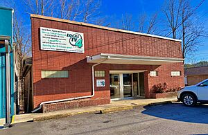
Local TV 4 is a television news station based in Murphy.
Communities in Cherokee County
Towns
Census-designated place
Village
Unincorporated Communities
- Bellview
- Culberson
- Friendship
- Grape Creek
- Hanging Dog
- Hothouse
- Liberty
- Martins Creek
- Owl Creek
- Peachtree
- Ranger
- Rhodo
- Texana
- Tomotla
- Topton
- Unaka
- Violet
- Wehutty
Townships
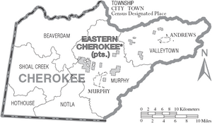
- Beaverdam
- Hothouse
- Murphy
- Notla
- Shoal Creek
- Valleytown
See also
 In Spanish: Condado de Cherokee (Carolina del Norte) para niños
 | Emma Amos |
 | Edward Mitchell Bannister |
 | Larry D. Alexander |
 | Ernie Barnes |


