Macon County, North Carolina facts for kids
Quick facts for kids
Macon County
|
|||
|---|---|---|---|
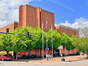
Macon County Courthouse in Franklin
|
|||
|
|||
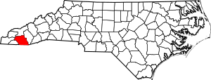
Location within the U.S. state of North Carolina
|
|||
 North Carolina's location within the U.S. |
|||
| Country | |||
| State | |||
| Founded | 1828 | ||
| Named for | Nathaniel Macon | ||
| Seat | Franklin | ||
| Largest community | Franklin | ||
| Area | |||
| • Total | 519.67 sq mi (1,345.9 km2) | ||
| • Land | 515.58 sq mi (1,335.3 km2) | ||
| • Water | 4.09 sq mi (10.6 km2) 0.79% | ||
| Population
(2020)
|
|||
| • Total | 37,014 | ||
| • Estimate
(2023)
|
38,412 | ||
| • Density | 71.79/sq mi (27.72/km2) | ||
| Time zone | UTC−5 (Eastern) | ||
| • Summer (DST) | UTC−4 (EDT) | ||
| Congressional district | 11th | ||
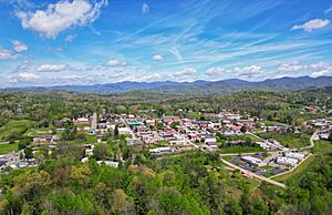
Macon County is a county in the state of North Carolina. It's located in the western part of the state. In 2020, about 37,014 people lived here. The main town and county seat is Franklin.
The Nantahala River flows through Macon County. It's famous for whitewater rafting, which is a popular outdoor activity.
Contents
History of Macon County
The river valleys in Macon County were once home to indigenous peoples, meaning the first people who lived there. Some of these groups built large earth mounds around 1000 AD. You can still see some of these mounds today. This area was also part of the homeland of the Cherokee people. The Cherokee in Western North Carolina are known as the Eastern Band of Cherokee Indians. This is a special group recognized by the U.S. government.
How Macon County Was Formed
Macon County was created in 1828. It was made from the western part of Haywood County. The county was named after Nathaniel Macon. He was an important person who represented North Carolina in the U.S. government for many years. He was even the Speaker of the House for a while.
The first courthouse in Macon County was built in Franklin in 1829. It was made of brick.
Changes to the County Borders
Over time, parts of Macon County were used to create other counties.
- In 1839, the western part of Macon County became Cherokee County.
- In 1851, parts of Macon County and Haywood County were combined to form Jackson County.
Courthouses Over Time
A new brick courthouse was built in 1881. It had two stories and was designed by William Gould Bulgin. The Clay County Courthouse was even designed to look like it!
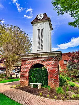
This historic courthouse was taken down in 1972 to make way for a new, modern courthouse. But don't worry, the old clock tower (called a cupola) was saved. You can still see it on display in a park in downtown Franklin.
Hospitals in Macon County
Macon County's first hospital opened in Franklin in 1923. In 1926, a new hospital called Angel Brothers Hospital was built. It was the first permanent hospital in North Carolina west of Asheville. It was later renamed Angel Hospital. A brand new Angel Medical Center was built in 2022.
Geography of Macon County
Macon County covers about 519 square miles. Most of this area is land (about 515 square miles), and a small part is water.
Nearly half of the land in Macon County (about 239 square miles) is part of the Nantahala National Forest. This is a special area managed by the United States Forest Service. It helps protect nature and wildlife.
The county's largest natural water source is the Cullasaja River. The Nantahala River also flows through the county and joins the Little Tennessee River. The famous Appalachian Trail, a long hiking path, also goes through the western part of Macon County.
In 2024, Macon County had many farms, with over 21,973 acres used for farming.
Protected Natural Areas
Macon County has several important protected areas:
- Appalachian Trail (part of it)
- Ellicott Rock Wilderness (part of it)
- Nantahala National Forest (part of it)
Local Protected Sites
- Euchella Site
- Fires Creek Wildlife Management Area (part)
- Nantahala National Forest Game Land (part)
- Needmore Game Land (part)
- Tessentee Bottomland Preserve
Amazing Waterfalls
Macon County is home to several beautiful waterfalls.
Cullasaja Falls
Cullasaja Falls is a waterfall east of Franklin. It's on the Cullasaja River within the Nantahala National Forest. The name "Cullasaja" comes from a Cherokee word. This waterfall is a long cascade, meaning the water flows down a rocky slope for about 0.2 miles. It's about 137 to 250 feet tall.
It can be tricky to see Cullasaja Falls well. It's located next to U.S. Highway 64 with sharp curves and steep cliffs. There's only a small spot to pull over, so be careful if you visit!
Dry Falls
Dry Falls, also known as Upper Cullasaja Falls, is a 65-foot waterfall. It's also in the Nantahala National Forest. What makes Dry Falls special is that you can walk *behind* the waterfall! When the water isn't too high, you can stay mostly dry, which is how it got its name. If there's a lot of water, you might get a little wet!
Dry Falls is located right off U.S. Highway 64. There's a parking area and a short path with stairs to get to the falls. The United States Forest Service made improvements to the area in 2009 to make it safer and easier to visit.
Bridal Veil Falls
Bridal Veil Falls is a 45-foot waterfall southeast of Franklin. It's unique because it's the only waterfall in North Carolina that you can drive your car under! The falls flow over a rocky overhang. Like Dry Falls, you can walk behind it and stay dry if the water flow is low.
This waterfall is also located on U.S. Highway 64. The highway used to go right behind the falls, but because of ice in winter, a new road was built around the front. There's a parking area where you can stop and enjoy the view.
Quarry Falls
Quarry Falls is a smaller waterfall or a large rapid. It's located next to US Hwy. 64. Locals sometimes call it "Bust Your Butt" because of the large, deep pool at the bottom. It's a very popular spot for swimming when the weather is warm.
Major Water Bodies
Macon County has many rivers and creeks, including:
- Beech Creek
- Blazed Creek
- Buck Creek
- Cartoogechaye Creek
- Chattooga River
- Cullasaja River
- Little Laurel Creek
- Little Tennessee River
- Middle Creek
- Nantahala Lake
- Nantahala River
- Queens Creek
- Tallulah River
- Tessentee Creek
Neighboring Counties
Macon County shares borders with these other counties:
- Swain County – to the north
- Jackson County – to the east
- Oconee County, South Carolina – to the southeast
- Rabun County, Georgia – to the south
- Clay County – to the southwest
- Cherokee County – to the west
- Graham County – to the northwest
Main Roads
Major highways that run through Macon County include:
 US 23
US 23 US 64
US 64
 US 64 Truck
 US 441


 US 441 Bus.
 NC 28
NC 28 NC 106
Important Facilities
- Macon County Airport
Population of Macon County
| Historical population | |||
|---|---|---|---|
| Census | Pop. | %± | |
| 1830 | 5,333 | — | |
| 1840 | 4,869 | −8.7% | |
| 1850 | 6,389 | 31.2% | |
| 1860 | 6,004 | −6.0% | |
| 1870 | 6,615 | 10.2% | |
| 1880 | 8,064 | 21.9% | |
| 1890 | 10,102 | 25.3% | |
| 1900 | 12,104 | 19.8% | |
| 1910 | 12,191 | 0.7% | |
| 1920 | 12,887 | 5.7% | |
| 1930 | 13,672 | 6.1% | |
| 1940 | 15,880 | 16.1% | |
| 1950 | 16,174 | 1.9% | |
| 1960 | 14,935 | −7.7% | |
| 1970 | 15,788 | 5.7% | |
| 1980 | 20,178 | 27.8% | |
| 1990 | 23,499 | 16.5% | |
| 2000 | 29,811 | 26.9% | |
| 2010 | 33,922 | 13.8% | |
| 2020 | 37,014 | 9.1% | |
| 2023 (est.) | 38,412 | 13.2% | |
| U.S. Decennial Census 1790–1960 1900–1990 1990–2000 2010 2020 |
|||
2020 Census Information
| Race / Ethnicity (NH = Not Hispanic) | Pop 2000 | Pop 2010 | Pop 2020 | % 2000 | % 2010 | % 2020 |
|---|---|---|---|---|---|---|
| White alone (NH) | 28,628 | 30,599 | 31,535 | 96.03% | 90.20% | 85.20% |
| Black or African American alone (NH) | 353 | 419 | 252 | 1.18% | 1.24% | 0.68% |
| Native American or Alaska Native alone (NH) | 79 | 143 | 167 | 0.27% | 0.42% | 0.45% |
| Asian alone (NH) | 117 | 201 | 250 | 0.39% | 0.59% | 0.68% |
| Native Hawaiian or Pacific Islander alone (NH) | 4 | 3 | 6 | 0.01% | 0.01% | 0.02% |
| Other race alone (NH) | 11 | 28 | 103 | 0.04% | 0.08% | 0.28% |
| Mixed race or Multiracial (NH) | 165 | 299 | 1,203 | 0.55% | 0.88% | 3.25% |
| Hispanic or Latino (any race) | 454 | 2,230 | 3,498 | 1.52% | 6.57% | 9.45% |
| Total | 29,811 | 33,922 | 37,014 | 100.00% | 100.00% | 100.00% |
As of the 2020 census, Macon County had 37,014 people. There were 15,921 households and 10,250 families living in the county.
Education in Macon County
Macon County has several schools for students.
Franklin High School
Franklin High School is a public high school in Franklin. It serves students in grades 9 through 12. It is part of the Macon County Schools district.
Union Academy
Union Academy is another public school in Macon County. It's an "alternative" school for grades 6 through 12. It's located near South Macon Elementary school. Its name was changed from Union Alternative in 2006.
Macon Early College
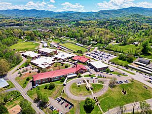
Macon Early College is a high school where students can also take college classes. It's located near the greenway and the public library in Franklin. Southwestern Community College (North Carolina) works with Macon Early College. This means students can earn college credits while still in high school!
News and Media
The Franklin Press is a newspaper that has been published every week in Franklin since 1888. It's the oldest business in Macon County that is still running! Before it, there were other newspapers in Macon County, but they didn't last very long.
Highlands, another town in Macon County, has its own newspaper called The Highlander. It has been published since 1958.
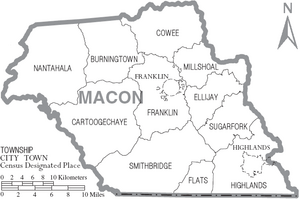
Communities in Macon County
Towns
Unincorporated Communities
These are smaller communities that are not officially towns.
- Aquone
- Cullasaja
- Etna
- Gneiss
- Holly Springs
- Iotla
- Kyle
- Leatherman
- Oak Grove
- Otto
- Peek's Creek
- Prentiss
- Rainbow Springs
- Scaly Mountain
- West's Mill
Townships
Townships are smaller areas within a county, often used for local government.
- Burningtown
- Cartoogechaye
- Cowee
- Ellijay
- Flats
- Franklin
- Highlands
- Millshoal
- Nantahala
- Smithbridge (formerly Smith's Bridge)
- Sugarfork
See also
 In Spanish: Condado de Macon (Carolina del Norte) para niños
 | Emma Amos |
 | Edward Mitchell Bannister |
 | Larry D. Alexander |
 | Ernie Barnes |


