Cullasaja River facts for kids
Quick facts for kids Cullasaja River |
|
|---|---|

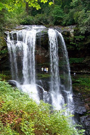
Dry Falls on the upper Cullasaja
|
|
|
Location of Cullasaja River mouth
|
|
| Other name(s) | Tributary to Little Tennessee River |
| Country | United States |
| State | North Carolina |
| County | Macon |
| Physical characteristics | |
| Main source | divide between Cullasaja River and Tuckasegee River about 1 mile south of Cowee Gap 4,150 ft (1,260 m) 35°05′23″N 083°09′06″W / 35.08972°N 83.15167°W |
| River mouth | Little Tennessee River Franklin, North Carolina 2,060 ft (630 m) 35°10′30″N 083°22′11″W / 35.17500°N 83.36972°W |
| Length | 23.25 mi (37.42 km) |
| Basin features | |
| Progression | northwest |
| River system | Little Tennessee River |
| Basin size | 92.58 square miles (239.8 km2) |
| Tributaries |
|
| Waterbodies | Ravenel Lake Mirror Lake Lake Sequoyah |
The Cullasaja River is a short river found completely in Macon County, North Carolina. It's like a smaller stream that flows into a bigger one, the Little Tennessee River. The Cullasaja joins the Little Tennessee near the town of Franklin. The Little Tennessee River then flows into the Tennessee, Ohio, and finally the huge Mississippi!
Contents
Where Does the Cullasaja River Start?
The Cullasaja River starts in the southeastern part of Macon County, close to Highlands. It flows out of a manmade lake called Lake Sequoyah. This lake gets its water from Mirror Lake and other small streams. These streams begin on the western side of the Eastern Continental Divide. This "divide" is like a ridge where water on one side flows to the Atlantic Ocean, and water on the other side flows to the Gulf of Mexico.
Exploring the Cullasaja Gorge
A special road called the Mountain Waters Scenic Byway follows the Cullasaja River through a deep valley known as the Cullasaja Gorge. This road is part of U.S. 64 and NC 28. Most of this area is protected as part of the Nantahala National Forest. The U.S. Forest Service has named this a National Scenic Byway because of the beautiful river and its many waterfalls.
Amazing Waterfalls to See
Along the Cullasaja River and its smaller streams, you can find several amazing waterfalls:
- Bridal Veil Falls: This waterfall is on a smaller creek that flows into the Cullasaja.
- Dry Falls: This is a unique waterfall where you can actually walk behind the water without getting wet!
- Quarry Falls: Also known as Bust-Yer-Butt Falls, it's a popular spot.
- Cullasaja Falls: This is the biggest and most impressive waterfall on the river itself.
Towns and Tributaries
The road changes names as you travel: it's called Franklin Road near Highlands and Highlands Road near Franklin. Below the gorge, there are two areas called townships: Sugarfork and Ellijay. The biggest stream that flows into the Cullasaja River is probably Buck Creek. Another well-known stream is Peek's Creek, where a big flood and mudslide happened in September 2004.
The River's Rich Cherokee History
The Cullasaja River area has a long and important history with the Cherokee people. Many historic Cherokee towns were located along the river.
Ancient Cherokee Towns
- Ellijay: This town was on Ellijay Creek, which flows into the Cullasaja River.
- Kulsetsiyi (or Sugartown): Several Cherokee towns had this name, including one on the Cullasaja River near Ellijay Creek. The name "Cullasaja" itself comes from a different spelling of "Kulsetsi". This is also where the name "Sugar Fork" comes from.
- Nikwasi: This was one of the largest and most important Cherokee towns. It was located right where the Cullasaja River meets the Little Tennessee River. Today, the town of Franklin is built on the same spot where Nikwasi used to be.
The Nikwasi Mound
What's left of the ancient Nikwasi town is a large earthwork platform mound. Experts believe this mound was built around 1000 CE by people of the South Appalachian Mississippian culture. For many years, after the Cherokee were forced to leave their land, the mound was owned by private individuals. But in 1946, the town of Franklin bought the site to protect this important historical landmark.
Protecting Cherokee Heritage Today
The Eastern Band of Cherokee Indians, who live on the Qualla Boundary in North Carolina, are working to preserve their heritage. They partnered with the town of Franklin to create a non-profit group called the Nikwasi Initiative. This group now helps take care of the Nikwasi mound and the land around it.
The tribe, the town, and a regional group called Mainspring Conservation Trust are working together to create a "cultural corridor" along the Little Tennessee River. In 2020, Mainspring bought another ancient Cherokee site, the Watauga Mound and part of Watauga Town, to give it back to the Eastern Band of Cherokee Indians. These two sites, along with Kituwa (which the tribe already owns again), will be connected. This will help people learn about and understand the rich history of the Cherokee people in this area.
 | James B. Knighten |
 | Azellia White |
 | Willa Brown |


