Graham County, North Carolina facts for kids
Quick facts for kids
Graham County
|
||
|---|---|---|
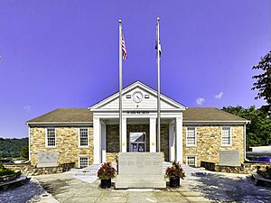
Graham County Courthouse in Robbinsville
|
||
|
||
| Motto(s):
"With A Proud History That Runs As Deep As The Roots of Her Trees"
|
||
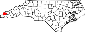
Location within the U.S. state of North Carolina
|
||
 North Carolina's location within the U.S. |
||
| Country | ||
| State | ||
| Founded | 1872 | |
| Named for | William A. Graham | |
| Seat | Robbinsville | |
| Largest community | Robbinsville | |
| Area | ||
| • Total | 301.65 sq mi (781.3 km2) | |
| • Land | 291.97 sq mi (756.2 km2) | |
| • Water | 9.68 sq mi (25.1 km2) 3.21% | |
| Population
(2020)
|
||
| • Total | 8,030 | |
| • Estimate
(2023)
|
8,052 | |
| • Density | 27.50/sq mi (10.62/km2) | |
| Time zone | UTC−5 (Eastern) | |
| • Summer (DST) | UTC−4 (EDT) | |
| Congressional district | 11th | |
Graham County is a county in the U.S. state of North Carolina. In 2020, about 8,030 people lived here. This makes it one of the least populated counties in North Carolina. The main town and county seat is Robbinsville.
Contents
History of Graham County
How Graham County Was Formed
Graham County was created on January 30, 1872. It was formed from the northeastern part of Cherokee County. The county was named after William Alexander Graham. He was a U.S. Senator and also a Governor of North Carolina.
Courthouse Buildings
The first courthouse in Robbinsville was built in 1874. Sadly, its floor collapsed during a trial many years later. A new wooden courthouse was built in 1895. This was the last wooden courthouse ever built in North Carolina. The current courthouse building was finished in 1942.
Public Library History
Graham County's first public library opened in Robbinsville in 1939. It joined the Nantahala Regional Library system a year later. The original building was replaced in 1952. The newer library opened its doors on April 6, 1953.
Notable Weather Events
In 1974, a strong tornado hit Graham County. It caused damage and sadly, two people lost their lives. The community of Stecoah, near Fontana Lake, was especially affected.
Geography and Natural Features
Graham County covers about 301 square miles. Most of this area is land, with a small part being water. The county is very mountainous. Its elevation ranges from about 1,177 feet to 5,560 feet high.
Nantahala National Forest
A large part of Graham County, about two-thirds, is covered by the Nantahala National Forest. The valleys in the county have rich soil. The name "Nantahala" comes from the Cherokee language. It means "land of the noon-day sun." This is because the steep mountains mean the sun is only visible in the valleys around midday.
Lakes and Dams
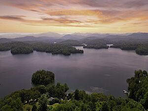
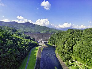
Fontana Lake forms most of the northern border of the county. The Great Smoky Mountains National Park is on the other side of the lake. Fontana Lake was created by Fontana Dam. This dam is the tallest dam in the eastern United States. Downstream from Fontana Dam, another lake is formed by Cheoah Dam. Both dams are managed by the Tennessee Valley Authority.
Rivers and Trails
The famous Appalachian Trail passes through Graham County. A part of this trail is even located on top of Fontana Dam. The Cheoah River is known for its exciting whitewater rapids. People enjoy whitewater rafting on this river about 17 days a year. This depends on when water is released from Santeetlah Dam. Most of the shoreline of Lake Santeetlah is next to the national forest.
Special Forests and Scenic Routes
Joyce Kilmer Memorial Forest is in northwestern Graham County. It's a rare example of an old-growth forest. This means its trees have been growing for a very long time. It is part of the Joyce Kilmer-Slickrock Wilderness area.
The Cherohala Skyway starts in northwestern Graham County. This scenic road is about 43 miles long. It connects Graham County with Tellico Plains, Tennessee.
Agriculture in Graham County
Graham County has one of the lowest amounts of farmland in North Carolina. In 2024, it had about 2,256 acres of agricultural land and 70 farms.
Cherokee Reserve
Parts of the Qualla Boundary are located in Graham County. The Qualla Boundary is land owned by the Eastern Band of Cherokee Indians. The Cherokee people who live in Graham County are part of the Snowbird Cherokee community.
Protected Natural Areas
Graham County is home to several important protected areas:
- Appalachian Trail (part)
- Cherohala Skyway (part)
- Great Smoky Mountains National Park (part)
- Joyce Kilmer-Slickrock Wilderness (part)
- Nantahala National Forest (part)
- Nantahala National Forest Game Land (part)
Major Water Bodies
Many creeks and rivers flow through Graham County:
- Deep Creek
- Fontana Lake
- Hooper Mill Creek
- Little Santeetlah Creek
- Little Tennessee River
- Santeetlah Creek
- Santeetlah Lake
- Snowbird Creek
- Tulula Creek
Neighboring Counties
Graham County shares borders with these counties:
- Blount County, Tennessee – to the north
- Swain County – to the northeast
- Macon County – to the southeast
- Cherokee County – to the south
- Monroe County, Tennessee – to the west
Main Roads
These are the major highways that go through Graham County:
 US 129
 NC 28
NC 28 NC 143
 NC 143 Bus.
Population Information
| Historical population | |||
|---|---|---|---|
| Census | Pop. | %± | |
| 1880 | 2,335 | — | |
| 1890 | 3,313 | 41.9% | |
| 1900 | 4,343 | 31.1% | |
| 1910 | 4,749 | 9.3% | |
| 1920 | 4,872 | 2.6% | |
| 1930 | 5,841 | 19.9% | |
| 1940 | 6,418 | 9.9% | |
| 1950 | 6,886 | 7.3% | |
| 1960 | 6,432 | −6.6% | |
| 1970 | 6,562 | 2.0% | |
| 1980 | 7,217 | 10.0% | |
| 1990 | 7,196 | −0.3% | |
| 2000 | 7,993 | 11.1% | |
| 2010 | 8,861 | 10.9% | |
| 2020 | 8,030 | −9.4% | |
| 2023 (est.) | 8,052 | −9.1% | |
| U.S. Decennial Census 1790–1960 1900–1990 1990–2000 2010 2020 |
|||
In 2020, Graham County had 8,030 residents. There were about 3,393 households living in the county. The population includes people from various backgrounds, including White, Native American, Black or African American, Asian, and Hispanic or Latino individuals.
In 2024, Graham County had some of the lowest access to computers and internet in North Carolina. It ranked 98th out of the state's 100 counties.
Local Media
The Graham Star is a newspaper published every week in Robbinsville. It has been printed since 1955.
Communities in Graham County
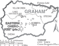
Graham County has several towns and smaller communities.
Towns
- Fontana Dam
- Lake Santeetlah
- Robbinsville (This is the county seat and the largest community.)
Townships
- Cheoah
- Stecoah
- Yellow Creek
Other Communities
Many smaller communities in Graham County are named after local features or early settlers. These include:
- Atoah
- Bear Creek Junction
- Cheoah
- Dentons
- Dry Creek
- Hidetown
- Jenkins Meadow
- Junction
- McGuires
- Meadow Branch
- Milltown
- Rymers Ferry
- Sawyers Creek
- Stecoah
- Sweetgum
- Tapoco (named after the Tallassee Power Company)
- Tulula (just south of Robbinsville)
- Tuskegee
- Yellow Creek
See also
 In Spanish: Condado de Graham (Carolina del Norte) para niños
 | Leon Lynch |
 | Milton P. Webster |
 | Ferdinand Smith |


