Monroe County, Tennessee facts for kids
Quick facts for kids
Monroe County
|
|
|---|---|

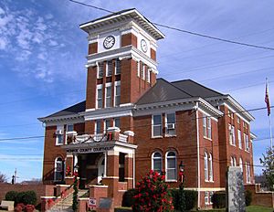
Monroe County Courthouse in Madisonville
|
|

Location within the U.S. state of Tennessee
|
|
 Tennessee's location within the U.S. |
|
| Country | |
| State | |
| Founded | November 13, 1819 |
| Named for | James Monroe |
| Seat | Madisonville |
| Largest city | Sweetwater |
| Area | |
| • Total | 653 sq mi (1,690 km2) |
| • Land | 636 sq mi (1,650 km2) |
| • Water | 17 sq mi (40 km2) 2.6%% |
| Population
(2020)
|
|
| • Total | 46,250 |
| • Estimate
(2023)
|
48,594 |
| • Density | 70.83/sq mi (27.346/km2) |
| Time zone | UTC−5 (Eastern) |
| • Summer (DST) | UTC−4 (EDT) |
| Congressional district | 3rd |
Monroe County is a county in the eastern part of Tennessee. It's located right on the border of the state. In 2020, about 46,250 people lived here. The main town, or county seat, is Madisonville. The biggest city in the county is Sweetwater.
Contents
History of Monroe County
Early Native American Settlements
Long ago, in the early 1700s, the area that is now Monroe County was home to the Overhill Cherokee. These were a group of the larger Cherokee Nation. Their towns and villages spread across the mountains of Virginia, the Carolinas, and parts of Tennessee, Georgia, and Alabama.
The Overhill Cherokee lived along the Little Tennessee and Tellico rivers. Some of their most important towns were Chota, Tanasi (which is where the name "Tennessee" comes from), and Great Tellico. Other towns in this area included Citico, Toqua, and Chilhowee.
Scientists have found very old tools and signs of people living here. At a place called Icehouse Bottom, artifacts show people lived there as early as 7500 B.C. Later, other groups lived here before the Cherokee arrived. The Cherokee are thought to have moved south from the Great Lakes area around 1000 CE. They spoke a language similar to other tribes around the Great Lakes.
European Settlers and Conflicts
In 1756, during the French and Indian War, the British built Fort Loudoun. This fort was on the Little Tennessee River. It was built to help the British get support from the Cherokee warriors.
However, things went wrong between the British and the Cherokee in 1760. The Cherokee attacked Fort Loudoun. They killed some soldiers after they surrendered and took others captive. The British fought back by attacking Cherokee towns in the Carolinas.
Forming Monroe County
Monroe County was officially created in 1819. This happened after a special agreement called the Calhoun Treaty. In this treaty, the Cherokee gave up their claims to lands from the Little Tennessee River south to the Hiwassee River. The county was named after President James Monroe. After this, many Cherokee people moved further south and west into Georgia and Alabama.
Some of the first gold mines in Tennessee were in Monroe County. In the early 1830s, people found gold in Coker Creek, near Tellico Plains.
Civil War and Development
During the American Civil War, Monroe County was one of the few counties in East Tennessee that supported leaving the United States. On June 8, 1861, the county voted to join the Southern states.
In the early 1900s, a company called Babcock Lumber cut down many trees in the Tellico Plains area. Around the same time, the Aluminum Company of America (ALCOA) started building dams. These dams were on the Little Tennessee River. They used the water power to make aluminum in a nearby town called Alcoa.
Later, the Tennessee Valley Authority (TVA) built the Tellico Dam. This dam was finished in 1979. It was built to control floods, make electricity, and create a large lake for fun activities. The new lake, Tellico Reservoir, covered 33 miles of the Little Tennessee River. Many people in the county were against the dam because they had to leave their homes. But others supported it. The dam project also caused a problem because it threatened a tiny fish called the snail darter. This caused delays in building the dam.
Geography of Monroe County
Monroe County covers about 653 square miles. Most of this is land, with about 17 square miles of water. The Unicoi Mountains are a big part of the county's southeastern side. These mountains are part of the larger Blue Ridge Mountains. The highest point in the county is Haw Knob, which is 5,472 feet tall.
The Little Tennessee River flows along the border with Blount County. Three man-made lakes are on this part of the river: Tellico Lake, Chilhowee Lake, and Calderwood Lake. The Tellico River also flows through the county. The Bald River, famous for its beautiful Bald River Falls, flows into the Tellico River.
Nearby Counties
- Loudon County (north)
- Blount County (northeast)
- Graham County, North Carolina (east)
- Cherokee County, North Carolina (southeast)
- Polk County (southwest)
- McMinn County (west)
Protected Natural Areas
- Bald River Gorge Wilderness
- Cherohala Skyway (part)
- Cherokee National Forest (part)
- Citico Creek Wilderness
State Parks and Historic Sites
- Fort Loudoun State Park
- Tellico Blockhouse State Historic Site
- Tellico Lake Wildlife Management Area (part)
Population and People
| Historical population | |||
|---|---|---|---|
| Census | Pop. | %± | |
| 1820 | 2,529 | — | |
| 1830 | 13,708 | 442.0% | |
| 1840 | 12,056 | −12.1% | |
| 1850 | 11,874 | −1.5% | |
| 1860 | 12,607 | 6.2% | |
| 1870 | 12,589 | −0.1% | |
| 1880 | 14,283 | 13.5% | |
| 1890 | 15,329 | 7.3% | |
| 1900 | 18,585 | 21.2% | |
| 1910 | 20,716 | 11.5% | |
| 1920 | 22,060 | 6.5% | |
| 1930 | 21,377 | −3.1% | |
| 1940 | 24,275 | 13.6% | |
| 1950 | 24,513 | 1.0% | |
| 1960 | 23,316 | −4.9% | |
| 1970 | 23,475 | 0.7% | |
| 1980 | 28,700 | 22.3% | |
| 1990 | 30,541 | 6.4% | |
| 2000 | 38,961 | 27.6% | |
| 2010 | 44,519 | 14.3% | |
| 2020 | 46,250 | 3.9% | |
| 2023 (est.) | 48,594 | 9.2% | |
| U.S. Decennial Census 1790-1960 1900-1990 1990-2000 2010-2014 |
|||
How Many People Live Here?
In 2020, there were 46,250 people living in Monroe County. There were also about 17,987 households, which are groups of people living together.
Most people in Monroe County are White. In 2020, about 89% of the people were White (not Hispanic). About 1.6% were Black or African American, and about 0.3% were Native American. About 4.2% of the people were Hispanic or Latino.
Education in Monroe County
Monroe County Schools serves most students in the county. This includes all grades up to high school. Students in Sweetwater go to Sweetwater City Schools for elementary and junior high.
Parks and Natural Wonders
A part of Monroe County is inside the Cherokee National Forest. This forest has two special wilderness areas: Citico Creek and Bald River Gorge. The Great Smoky Mountains National Park is also nearby, just across the border in Blount County.
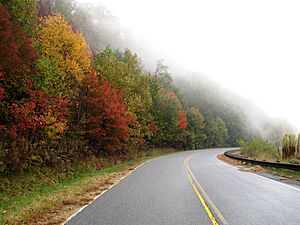
The Cherohala Skyway is a beautiful road that goes through the mountains. It connects Tellico Plains in Tennessee with Robbinsville in North Carolina. This road reaches over 5,000 feet high!
Fort Loudoun State Park is on a piece of land sticking into a lake near Vonore. It has a copy of the old Fort Loudoun from the 1700s. The Tellico Blockhouse site is across the river. You can see where the old blockhouse (a type of fort) stood in the 1790s. The Sequoyah Museum is also nearby. It teaches about Sequoyah, a Cherokee scholar who created a writing system for his language.
The Lost Sea is a famous cave located about 7 miles from Sweetwater. It has the largest underground lake in North America! A 13-year-old boy named Ben Sands found the lake in 1905. Today, you can take a boat ride on the lake. In 1940, scientists found old bones and footprints of jaguars in the cave. These jaguars lived a very long time ago.
Transportation
Several main roads run through Monroe County. U.S. Route 411 goes through Madisonville and Vonore. U.S. Route 11 goes through Sweetwater. State Route 68 connects Sweetwater, Madisonville, and Tellico Plains. Interstate 75 also passes through a small part of the county near Sweetwater.
The Monroe County Airport is a small airport near Madisonville.
Communities in Monroe County
Cities
- Madisonville (the county seat)
- Sweetwater
Towns
- Tellico Plains
- Vonore (partially in another county)
Other Communities
- Coker Creek
- Kahite
- Rarity Bay (partially in another county)
- Ballplay
- Hopewell Mill
- Hopewell Springs
- Jalapa
- Toqua
Famous People from Monroe County
- Estes Kefauver: A U.S. senator.
- Sequoyah: A Cherokee scholar who created a writing system for the Cherokee language. He was born near Vonore.
- Nancy Ward: An important Cherokee leader, born in Chota.
- Sharon Gail Lee: A judge on the Tennessee Supreme Court.
See also
 In Spanish: Condado de Monroe (Tennessee) para niños
 | Roy Wilkins |
 | John Lewis |
 | Linda Carol Brown |


