
Toqua (Tennessee) facts for kids
Quick facts for kids |
|
|
Toqua Site
|
|

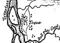
Toqua as shown on Henry Timberlake's 1762 Draught of the Cherokee Country
|
|
| Location | Monroe County, Tennessee |
|---|---|
| Nearest city | Vonore |
| Built | circa 900-1000 |
| NRHP reference No. | 78002618 |
| Added to NRHP | 1978 |
Toqua (Cherokee: ᏙᏉ, romanized: Toquo) was an important Native American site in Monroe County, Tennessee. It was once a large town where people lived long ago, especially during the Mississippian period (from about 1000 to 1600 CE).
The people of Toqua built a large earth mound, like a big platform, that was about 25 feet (7.6 meters) tall. There was also a second, smaller mound. Some historians believe the Spanish explorer Hernando de Soto might have visited this town in 1540, calling it "Tali." Later, it became known as the Overhill Cherokee town of Toqua.
In 1967, experts studied the Toqua site because the Tellico Dam project was going to flood the area. It was one of the last remaining sites with a special type of mound from the Dallas phase of the Mississippian culture. In 1978, the site was added to the National Register of Historic Places. A year later, in 1979, the Toqua site was covered by water when the Little Tennessee River was dammed, creating Tellico Lake. Today, the area above the submerged site is a fun place for recreation, managed by the Tennessee Wildlife Resources Agency.
Contents
Where Was the Toqua Site Located?

The Little Tennessee River flows from the Appalachian Mountains through northern Monroe County. It travels about 40 miles (64 km) before joining the Tennessee River. In 1979, the Tellico Dam was built, creating Tellico Lake. This lake now covers the lower 33 miles (53 km) of the Little Tennessee River.
The Toqua site was located on the south bank of the Little Tennessee River, right where Toqua Creek flows into it. This spot was about 22 miles (35 km) upstream from where the river meets the Tennessee River.
Today, the land above the submerged Toqua site is called the Toqua Day Use Area Beach and Boat Ramp. You can find it along Tennessee State Route 360, about 2 miles (3.2 km) south of U.S. Route 411 in Vonore. You can easily see the area from the road and the boat ramp.
A Look at Toqua's Past
Early History with Spanish Explorers

The expedition led by Hernando de Soto traveled through the upper Tennessee Valley between 1539 and 1543. They were looking for a way to reach the Pacific Ocean. After landing in Florida, they marched north through what is now Georgia, South Carolina, and North Carolina. They crossed the Blue Ridge Mountains and entered the Tennessee Valley.
After staying for several weeks at a place called Chiaha (near modern Douglas Dam), the expedition followed the French Broad and Tennessee Rivers. They reached a village called Coste, located on Bussell Island. On July 9, 1540, de Soto's group left Coste and followed the Little Tennessee River. They arrived at the village of Tali, which is now known as the Toqua site.
The Spanish explorers wrote that the river was too deep to cross there. When the villagers of Tali saw the Spaniards, they panicked and tried to escape in canoes. De Soto's soldiers made them return. The chief of Tali gave the expedition some women and porters. De Soto and his forces left the next day. The chief of Tali continued to send food, like sofkee (a type of porridge), to the expedition until they reached the Coosa chiefdom on July 16.
The Cherokee Period at Toqua
The name "Toqua" comes from the Cherokee language word Dakwa'yi, which means "fish place." This name comes from a Cherokee story about a "Great Fish" called Dakwa that lived at the mouth of Toqua Creek.
The name Toqua first appeared in historical records in 1751. At that time, it was home to an English trader named Anthony Dean. In 1756, Toqua sent 30 warriors to help the British during the French and Indian War. Willanawaw was the chief of Toqua then. He had also been a chief of the nearby town of Tanasi.
Henry Timberlake visited the Overhill Cherokee towns on a peace mission in 1761. He noted that Willanawaw was still the leader at Toqua. Timberlake reported that the town had 32 houses and a councilhouse. The councilhouse was built on top of the town's platform mound, which was a common practice.
As more European-American settlers moved west, the town of Toqua began to shrink. The Overhill towns faced many attacks during the American Revolutionary War and the Cherokee–American wars (1776–1794). Toqua was destroyed by John Sevier in 1788.
In the late 1790s, Louis-Philippe, who would later become the king of France, visited the Tellico Blockhouse. He was traveling while in exile. Louis-Philippe described a councilhouse and 8 to 10 houses about 3 miles (4.8 km) south of the blockhouse. This would have been close to where Toqua was located. He gave a detailed description of the councilhouse.
Toqua still had a small number of people living there when the Cherokee sold their lands along the Little Tennessee River to the U.S. government in 1819. This was part of the Calhoun Treaty. Soon after, an early settler named John McGhee bought thousands of acres, including the Toqua site. McGhee's family still owned the land in the mid-20th century. Then, in the 1960s, the Tennessee Valley Authority started buying the land to build the dam and Tellico Reservoir.
Studying Toqua: What Archeologists Found
John W. Emmert, from the Smithsonian's Bureau of Ethnology, did the first archeological study of the Toqua area in 1884. In the 1930s, a treasure hunter named George Barnes dug for artifacts at the Toqua site. He found many human bones, but unfortunately, he threw most of them away.
In 1967, the University of Tennessee's Department of Anthropology began an initial survey of the area. They wanted to find sites for further research before the Tellico Dam flooded the land. Toqua was chosen for a deeper study because it was the last remaining Dallas-phase platform mound site in the valley.
One main goal of the University of Tennessee's research was to find out if there was a connection between the Mississippian-period people and the later Cherokee people who lived in the Little Tennessee Valley. They also wanted to figure out the exact time the Cherokee lived there and look for signs of people living there even before the Mississippian period.
Discoveries from the Mississippian Period

During the excavations at Toqua in the 1970s, archeologists found many things typical of a Mississippian-period village. The village had a central, flat area covered with pebbles, which was likely a plaza. Next to it was a large "platform" mound (called "Mound A") and 57 homes. A smaller mound, "Mound B," was in the southeastern part of the village.
At its busiest time, around 1400 CE, the village covered about 4.8 acres (0.019 km²). Later, its size became much smaller. The village was surrounded by a clay-covered palisade (a fence of strong posts) with lookout towers every 60 feet (18 m). Besides showing the village's layout, the dig uncovered 477 human burials, 212 whole or broken ceramic pots, and thousands of stone tools.
The Mississippian structures found at Toqua included the two mounds and several homes. Mound A was built in 16 different stages, probably starting in the 10th century CE. This mound was about 25 feet (7.6 m) high and 154 feet (47 m) wide. On top of it were two buildings. The largest building was about 100 feet (30 m) by 83 feet (25 m) and had a central fireplace and benches. Archeologists found a chert sword, a pot full of marsh elder seeds, and two burials of high-status women in Mound A.
Mound B was 6 feet (1.8 m) high and 93 feet (28 m) wide. It contained many cremated human remains (ashes of people who were burned). A typical Mississippian-period home at Toqua had about 400 square feet (37 m²) of living space, a central fireplace, storage areas, and inner walls.
Scientists studied the human remains found at Toqua. They found that the average male was about 5 feet 6 inches (168 cm) tall, and the average female was about 5 feet 1 inch (155 cm) tall. The average life expectancy was about 17.1 years for males and 15.1 years for females. Many of the remains showed signs of iron deficiency. This might have been because their diet relied too much on corn and not enough on meat. At its peak, the village probably had between 250 and 300 people.
Toqua was likely the most important village in the Little Tennessee Valley between 1250 and 1500 CE. An increase in mass burials and the village shrinking by almost half in the 16th century suggest that Toqua might have been declining. Other Dallas phase villages like Tomotley (very close to Toqua) and Citico (several miles upstream) became more important.
What We Still Don't Know
Archeologists were able to figure out a general time period for the Cherokee living at Toqua by matching their findings with historical records. However, the main goal of the project was to find the link between the people who lived at Toqua before the Cherokee and the Cherokee themselves. This question remains unanswered. Investigators did not find clear proof that people lived there continuously from the Mississippian period to the Overhill Cherokee period. The connection between these different groups of people in the Little Tennessee Valley is still a mystery.
Images for kids
-
Toqua as shown on Henry Timberlake's 1762 Draught of the Cherokee Country
-
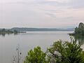
The now-submerged former site of Toqua
-
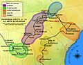
A map showing the route of Hernando de Soto across the southeastern U.S.
-
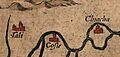
The villages of Chiaha, Coste, and Tali in what is now East Tennessee as they appeared on Chiaves's 1584 map of La Florida
