Tanasi facts for kids
Quick facts for kids |
|
|
Chota and Tanasi Cherokee Village Sites
|
|
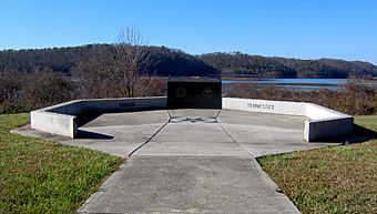
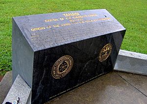
Monument overlooking the Tanasi site
|
|
| Location | Monroe County, Tennessee |
|---|---|
| Nearest city | Vonore |
| Built | c. 1600–1700 A.D. |
| NRHP reference No. | 73001813 |
| Added to NRHP | 1973 |
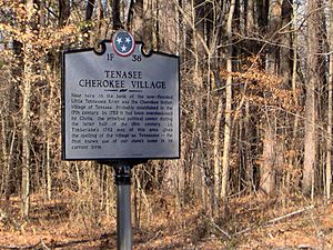
Tanasi (Cherokee: ᏔᎾᏏ, romanized: Tanasi) was an important historic Overhill Cherokee village in what is now Monroe County, Tennessee. This village gave its name to the state of Tennessee. The Cherokee people left Tanasi in the 1800s for a new town with a more powerful leader.
From about 1721 to 1730, Tanasi was like the main capital for the Overhill Cherokee. After 1730, the capital moved to Great Tellico.
The Cherokee town of Chota grew up right next to Tanasi, just to its north. A small stream separated the two towns. By the 1740s, Chota became more important than Tanasi. It had the main meeting house where the community gathered and where chiefs met with visitors from the colonies.
Even though Chota and Tanasi were seen as separate towns, archaeologists found that they looked very similar when they dug them up. They were both part of many "Overhill Towns." These towns were called "Overhill" by English colonists who traveled over the Appalachian Mountains to reach them. Today, Chota and Tanasi are listed together as one important historical site.
Both sites were later covered by water when the Tellico Reservoir was created. This happened after a dam was finished on the Little Tennessee River in 1979. Before the flooding, archaeologists carefully studied these sites in the 1970s. They found thousands of old items.
In the 1980s, the Tennessee Valley Authority placed a monument near where Tanasi used to be. This monument remembers the town's history and how it gave Tennessee its name. You can find this monument about 7 miles (11 km) southeast of Vonore, off Highway 455. The Eastern Band of the Cherokee Nation helps manage this special site.
Contents
Where were the Tanasi and Chota Villages?
The Little Tennessee River flows northwest from its start in the Appalachian Mountains. It travels about 40 miles (64 km) through northern Monroe County. Then, it flows into the Tennessee River.
In 1979, the Tellico Dam was built. This dam created a large lake called the Tellico Reservoir. This lake now covers the lower 33 miles (53 km) of the Little Tennessee River. It also covers 22 miles (35 km) of the Tellico River, which is a smaller river that flows into it. Many important Cherokee town sites were flooded by this new lake.
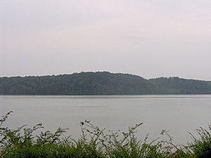
Tanasi was located on the west bank of the Little Tennessee River. It was about 27 miles (43 km) upstream from where the river meets the Tennessee River. The site was across from a sharp bend in the river called Bacon's Bend.
Tanasi sat on a flat area of land. The river was on one side, and tall, steep hills were on the other. These hills are part of the Ridge-and-Valley Appalachians. This mountain range covers much of the upper Tennessee Valley. The main Appalachian Mountains are just a few miles south of where Chota and Tanasi were.
What is the History of Tanasi?
We first learn about Tanasi in historical records in the early 1700s. This was a time when the fur trade between the English and the Cherokee was growing. The English wanted to control this trade.
The meaning of the name "Tanasi" is not known. However, it was used for other places in Cherokee lands in Tennessee and North Carolina. The Cherokee name for the river near Tanasi was probably Callamaco. Early European explorers and traders later named the river after the town of Tanasi.
One of the first English traders to live in Tanasi was Eleazar Wiggan. The Cherokee called him "Old Rabbit." He worked in Tanasi as early as 1711. He also helped guide later colonial visitors.
In 1725, South Carolina sent Colonel George Chicken to Tanasi. He wanted the Cherokee to help them in their fights with the Creek. Chicken wrote in his journals that the chief of Tanasi, called the Tanasi Warrior, was a very powerful leader. Chicken recorded a speech where the Tanasi Warrior promised to support the English. They later smoked a peace pipe together. The Tanasi Warrior told Chicken about recent attacks by the Creek in the area.
In 1730, a trader named Sir Alexander Cuming came to Tanasi. He claimed to be sent by King George II. Cuming convinced the Tanasi Warrior to promise loyalty to England. To show his success, Cuming wanted a special headdress called the Crown of Tanasi. It was described as looking like a wig made of dyed possum hair. He wanted to give it to the King of England.
To get this headdress, Cuming asked for help from Moytoy, the chief of Great Tellico. Cuming used his showy style to convince the Cherokee to crown Moytoy "Emperor of the Cherokee." In return, Moytoy helped Cuming get the headdress. Cuming then left for England. He took with him a group that included Eleazar Wiggan, future Cherokee leader Attakullakulla, and two Tanasi warriors.
The crowning of Moytoy in 1730 moved the main Cherokee power center to Great Tellico. This town was about 16 miles (26 km) southwest of Tanasi. But after Moytoy died in 1741, Old Hop, the chief of Chota, started to gain more power.
Chota's influence soon became greater than Tanasi's. By the early 1750s, Chota was the more important town. In 1765, Henry Timberlake visited the Overhill towns. He reported that Tanasi had 12 homes and 21 warriors. He also said that Old Hop was the chief of both Chota and Tanasi. In 1775, the Tanasi Warrior was one of the chiefs who signed a treaty. This treaty was with the Watauga Association of colonists from Carolina. These colonists wanted to create their own area west of the mountains, in what became Tennessee.
How were Tanasi and Chota Related?
Historians and archaeologists have long wondered about the relationship between Tanasi and Chota. Some thought they might have been one community with two parts and two governments. This was similar to what was reported in Great Tellico and Chatuga around the same time.
Archaeologists found almost no differences in the types of items and features at the two village sites. These sites grew on opposite sides of a creek. However, traders and visitors in the 1700s clearly said they were two separate towns.
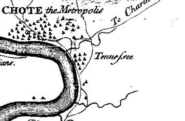
European traders first wrote about Tanasi when they explored the area in the early 1700s. But Chota does not appear in historical records until about 1745. Maps from 1727 and 1730 show Tanasi but not Chota. In 1746, an English agent met with Cherokee leaders at the Chota meeting house. This shows that Chota had become more important than Tanasi.
A missionary named William Richardson visited the Overhill towns in the late 1750s. He said Chota and Tanasi were separated by a "small river." Timberlake's map from 1762 also shows the two towns' locations.
What Did Archaeologists Find?
Cyrus Thomas, working for the Smithsonian Institution in the late 1880s, studied a mound at the Chota-Tanasi site. He found 13 burials and several old items.
In 1939, Thomas Lewis and Madeline Kneburg led another dig at the Chota-Tanasi site. They found 22 burials, 85 pit features, and parts of 6 structures.
The sites were later threatened by flooding from a dam project. So, between 1969 and 1974, archaeologists from the University of Tennessee dug at the Chota-Tanasi site. They wanted to learn its history and save as many items as possible. Two digs, in 1970 and 1972, focused only on Tanasi.
Archaeologists found items from very old times, like the Archaic period. They even found a spear point from the Paleo-Indian period. But the main focus was on the time when the Cherokee lived there. Researchers hoped to find where each town was located. They also wanted to see how the Cherokee people were connected to the earlier people of the South Appalachian Mississippian culture (from about 1000 to 1600 A.D.).
The 1972 digs at the Tanasi site alone found 191 features, 22 burials, and 6 structures. Two townhouses were found at the Chota-Tanasi sites. One was a bit smaller and older than the other. The older townhouse might have been the Tanasi townhouse that traders wrote about in the 1720s. However, it could also be an earlier version of the Chota townhouse. The older townhouse was about 50 feet (15 m) across.
In 1986, the remains of the 22 burials found at Tanasi, along with those from Chota, were reburied. They were placed in a special burial mound at the Sequoyah Museum near Vonore.
Resources
- Mooney, James. "Myths of the Cherokee" (1900, reprint 1995).
 | Emma Amos |
 | Edward Mitchell Bannister |
 | Larry D. Alexander |
 | Ernie Barnes |


