Tomotley facts for kids
Quick facts for kids |
|
|
Tomotley Site
|
|

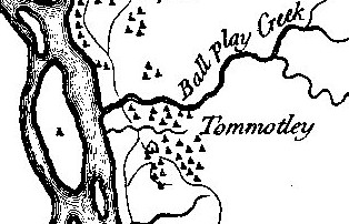
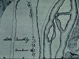
Tomotley on Henry Timberlake's 1762 Draught of the Cherokee Country
|
|
| Location | Monroe County, Tennessee |
|---|---|
| Nearest city | Vonore |
| Built | circa 1000 A.D., 1751 A.D. |
| NRHP reference No. | 78002617 |
| Added to NRHP | 1978 |
Tomotley (also called Tamahli) was an important Native American site in Monroe County, Tennessee. It was located along the Little Tennessee River. People lived here for a very long time.
The site was first used around 8000 to 1000 BCE during the Archaic period. It was especially busy during the Mississippian culture period. This was when large earthwork mounds were likely built. Later, in the 1700s, it became a Cherokee town. What was special about Tomotley was its unique buildings. It had an eight-sided council house and square or rectangle homes. Other Cherokee towns in the area usually had round houses.
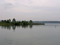
Today, the Tomotley site is underwater. It was covered by Tellico Lake in the late 1900s. This happened after a dam was built by the Tennessee Valley Authority. You can still see the area where Tomotley once was from Toqua Beach. You can also see it from the Toqua Boat Ramp. These spots are managed by the Tennessee Wildlife Resources Agency.
Contents
Where Was Tomotley Located?
The Little Tennessee River flows through northern Monroe County for about 40 miles (64 km). It starts near the Tennessee-North Carolina border. It then flows into the Tennessee River near Lenoir City.
In 1979, the Tellico Dam was built. This created Tellico Lake. The lake now covers the lower 33 miles (53 km) of the Little Tennessee River. It also covers 22 miles (35 km) of the Tellico River.
The Tomotley site was on the south side of the Little Tennessee River. It was just north of where Toqua Creek meets the river. This spot was about 22 miles (35 km) from the river's mouth. The historic Cherokee village of Toqua was nearby. It was on the south side of Toqua Creek, across from Tomotley.
Toqua Beach and the Toqua Boat Ramp are great places to see the Tomotley site. They are located along Tennessee State Route 360. This road is about 2 miles (3.2 km) south of U.S. Route 411 in Vonore.
A Look Back in Time: Tomotley's History
What Does the Name "Tomotley" Mean?
No one knows for sure where the name "Tomotley" came from. Most people think it was used before the Cherokee lived there. A researcher named James Mooney thought it might come from the Muscogee Creek language. He noticed it sounded like Tama'li, a Creek town in Georgia. The Creek people lived in this area before the Cherokee.
Some people also think Tomotley was settled by Cherokee people. These Cherokee were from other towns in South and North Carolina. They were escaping wars with the Creek in the mid-1700s. The name "Tomotley" was also used for other Cherokee towns.
Tomotley as a Cherokee Town
Tomotley first appeared in European records in 1756. At that time, a Cherokee chief named Attakullakulla was its leader. In the same year, a small English army arrived. They were led by Captain Raymond Demeré. Their job was to build Fort Loudoun nearby. The British wanted to protect the Cherokee. They hoped the Cherokee would be their friends in the French and Indian War.
The chief, Conocotocko (also called Old Hop), greeted the soldiers at Tomotley. He told Demeré he was old and his life was short. William de Brahm designed the fort. He lived in Tomotley while the fort was being built in late 1756.
During this time, there was a big disagreement among the Cherokee leaders. Some wanted to be friends with the French. Others wanted to be friends with the English. Tensions were high because of the Seven Years' War in Europe. This war was known as the French and Indian War in North America.
A pro-English leader named Ostenaco had to leave his town. He moved to the Little Tennessee Valley. By 1761, when an English explorer named Henry Timberlake visited, Ostenaco was the governor of Tomotley.
During the American Revolution, many Cherokee towns were destroyed. Tomotley was important because it was easy to cross the river there. So, it was one of the first towns captured in 1776. This happened during an expedition led by William Christian. Three years later, another leader, John Sevier, found Tomotley still in ruins.
Digging Up the Past: Archaeology at Tomotley
The first big archaeological dig at Tomotley was in the 1880s. It was done by J.W. Emmert from the Smithsonian Institution. He found two earthwork mounds at the site. One mound was 8 feet (2.4 m) high and 58 feet (18 m) wide. Both mounds contained human burials.
In the late 1900s, the Tennessee Valley Authority planned to build the Tellico Dam. This would flood many important historical sites. So, the University of Tennessee's Department of Anthropology was hired. They started exploring the area in 1967. They did test digs at Tomotley to find the old village.
When the dam project slowed down, more detailed digs happened in 1973, 1974, and 1976. These digs found 19 Cherokee and pre-Cherokee buildings. This included Tomotley's Cherokee council house. They also found 18 human burials. Thousands of artifacts were found too. These included items made of ceramic, stone, and bone.
The digs showed that people lived at Tomotley during the Archaic period (8000 to 1000 BC). They also lived there during the Woodland period. But the busiest times were during the South Appalachian Mississippian culture period (1000-1500 AD). This is when the earthwork mounds were built. The 1700s, when the Overhill Cherokee lived there, was also a busy time. Many European-American items were found too. Some might have come from the Fort Loudoun soldiers.
Cherokee Life at Tomotley
Before the digs, historians thought Tomotley was founded by Cherokee people. These people were escaping wars with the Creek and English. The digs in 1976 aimed to learn more about this idea. They wanted to find the council house and study the Cherokee homes. They also wanted to understand the village layout.
The homes found at Tomotley gave clues about earlier times. Of the 19 buildings found, the council house was eight-sided. The other homes were square or rectangular. This was surprising! Historical records said Overhill Cherokee homes were usually round "winter" houses and rectangular "summer" houses. Digs at other Overhill sites like Toqua and Chota found many round buildings.
But round buildings were not common in other Cherokee towns. These were the Lower and Valley Cherokee towns in the Carolinas. Other clues also support the idea that refugees from these areas lived at Tomotley. For example, the pottery found looked more like pottery from the Middle and Chickamauga Cherokee (Lower Cherokee) areas. It was different from Overhill pottery.
 | Emma Amos |
 | Edward Mitchell Bannister |
 | Larry D. Alexander |
 | Ernie Barnes |


