
Tellico River facts for kids
Quick facts for kids Tellico River |
|
|---|---|

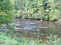
The Tellico River near Tellico Plains, Tennessee
|
|
| Country | United States |
| State | North Carolina, Tennessee |
| Physical characteristics | |
| Main source | near McDaniel Bald in Cherokee County, North Carolina 4,200 ft (1,300 m) 35°14′52″N 84°0′19″W / 35.24778°N 84.00528°W |
| River mouth | Little Tennessee River at Vonore, Tennessee 814 ft (248 m) 35°36′13″N 84°12′45″W / 35.60361°N 84.21250°W |
| Length | 52.8 mi (85.0 km) |
| Basin features | |
| Basin size | 285 sq mi (740 km2) |
| Tributaries |
|
The Tellico River is a beautiful river that flows through the Blue Ridge Mountains in western North Carolina and eastern Tennessee. It starts high up in the mountains of North Carolina. Then, it travels through Monroe County, Tennessee, before joining the Little Tennessee River in the Tellico Reservoir.
The Tellico River is about 52.8 miles (85.0 km) long. It's a very important stream that drains a large area of the Unicoi Mountains. The river and its smaller streams are famous for their great fishing. You can find different types of trout here, like brook, brown, and rainbow trout. Upstream from Tellico Lake, especially above Tellico Plains, Tennessee, the Tellico is a top spot for trout fishing. It winds through a mountain valley before reaching the flatter lands near Tellico Plains.
Contents
The River's Journey
The Tellico River begins in the Unicoi Mountains. These mountains are part of the larger Blue Ridge Mountains. The river starts near the border of Cherokee and Graham counties in North Carolina. This area is part of the Nantahala National Forest. On the North Carolina side, there's a special area for off-highway vehicles called the Upper Tellico OHV area.

As the river crosses into Tennessee, it enters the Cherokee National Forest. Here, two important rivers join the Tellico: the Bald River and the North River. After leaving the mountains, the river flows into Tellico Plains. This is a flat, quiet area shaped by the river and its smaller streams. A 4-mile (6.4 km) part of the river above Tellico Plains runs right next to the Cherohala Skyway.
Beyond Tellico Plains, the river moves north through the countryside of Monroe County, Tennessee. It then reaches the calm waters of Tellico Lake. Along this lower part of the river, several other streams flow into it, like Ballplay Creek and Notchy Creek. These names come from an old map made by Henry Timberlake in the 1760s. He explored the area where the Overhill Cherokee lived.
Fort Loudoun was an old British fort from the 1700s. It was built on an island where the Tellico River meets the Little Tennessee River. Today, it's a state park. In 1760, the Cherokee people surrounded the fort and defeated the soldiers. They wanted the British to leave their land.
History of the Tellico River Area

The Tellico River area was a very important part of the homeland for the Cherokee people. They lived in what is now South Carolina, North Carolina, Tennessee, and Georgia. The Overhill Cherokee had many towns along the lower Little Tennessee River and upper Tennessee River.
A British explorer named Henry Timberlake visited these towns in 1761-1762. He drew a very detailed map called "Draught of the Cherokee Country." He also wrote a book about the chiefs and people in these towns.
After many conflicts, the United States government moved most of the Cherokee and other Native American tribes away from their lands in the 1830s. They were forced to move to Indian Territory, which is west of the Mississippi River. After this, European Americans settled in the area and started farming.
In the early 1900s, a company called Babcock Lumber Company cut down many trees in the Tellico River basin. The road you see today along the Tellico River was built on the old railroad tracks used by Babcock for logging. After cutting down most of the trees, Babcock sold the land to the United States Forest Service.
Fun on the Tellico River Today
The Tellico River is a great place for whitewater activities. Its rocky path creates exciting rapids, perfect for adventure. These rapids are especially popular in the spring when the water levels are higher. The narrow, fast rapids are best for kayaks, canoes, and inflatable boats called "duckies." They are not usually suitable for larger rafts.
You can easily get to the river from the road. Here are some popular sections for whitewater fun:
- Trout Hatchery to Bridge: This section is above where the Bald River joins. It has class II-III rapids, which are moderately challenging.
- The Ledges: This part goes from the bridge above the Bald River to the bridge below Jared's Knee. It has class III-IV rapids, which are more difficult and exciting.
- Bridge below Jared's Knee to Ranger Station: This section has class II-III rapids.
- Ranger Station to Tellico Plains: This final stretch has easier class I-III rapids.
What Does "Tellico" Mean?
The name "Tellico" has been spelled in different ways over time. Some old names include Delaquay River, Talequo River, Terrique River, and Tellequo River. Henry Timberlake used the spelling "Tellequo" on his map from 1761-1762.
"Tellico" was the name of several Cherokee towns. The biggest one was Great Tellico, located near what is now Tellico Plains, Tennessee. In the Cherokee language, the word is actually Talikwa.
According to a historian named James Mooney, the original meaning of the word "Talikwa" in Cherokee has been lost. However, many believe the word comes from the Muscogee (Creek) language. Spanish explorers visited this area in the mid-1500s and recorded a Muscogee town called Taliko on the Tellico River. In the Muscogee language, "Taliko" means "bean."
Images for kids
-
The Tellico River near Tellico Plains, Tennessee
-
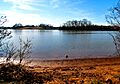
The lower Tellico River, near the Sequoyah Birthplace Museum
-
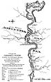
Timberlake's "Draught of the Cherokee Country" map
