
Cherohala Skyway facts for kids
Quick facts for kids
[[File:|x70px|alt= marker]] |
|
|---|---|
| Route information | |
| Maintained by TDOT & NCDOT | |
| Length | 43 mi (69 km) |
| Existed | October 11, 1996–present |
| Component highways |
|
| Location | |
| States: | Tennessee, North Carolina |
| Counties: | Monroe, TN; Graham, NC |
| Highway system | |
| Tennessee State Routes Interstate • USNorth Carolina Highway System |
|
The Cherohala Skyway is a beautiful 43-mile (69 km) road that winds through mountains in the southeastern United States. It's known as a National Scenic Byway and a National Forest Scenic Byway. This means it's a special road recognized for its amazing views and natural beauty.
The Skyway connects Tellico Plains, Tennessee to Robbinsville, North Carolina. Its name is a mix of two words: Cherokee and Nantahala. These are the two national forests the road travels through.
Along the Skyway, you'll find many places to stop and enjoy the views. It also gives easy access to parts of the Unicoi Mountains. These areas include the Citico Creek Wilderness, the Bald River Gorge Wilderness, and the Joyce Kilmer Memorial Forest.
Planning for the Cherohala Skyway began way back in 1958. It took a long time to build, finally opening on October 12, 1996. The total cost was about $100,000,000.
The western part of the Skyway is in Tennessee. It follows Tennessee State Route 165 for almost 25 miles (40 km). This section goes from Tellico Plains to the state line at Stratton Gap.
The eastern part is in North Carolina. It follows North Carolina Highway 143 for just over 18 miles (29 km). This section runs from Stratton Gap to Robbinsville.
The Skyway climbs a lot in elevation. It starts low at Tellico Plains, around 900 feet (270 m) high. It then rises to over 5,400 feet (1,600 m) near the Tennessee-North Carolina state line. The North Carolina end of the Skyway is close to Lake Santeetlah.
Exploring the Cherohala Skyway
The Cherohala Skyway offers many exciting stops and viewpoints. It's a great way to see the natural beauty of the mountains.
Highlights Along the Route
Here are some popular spots you can visit along the Skyway:
- Santeetlah Gap (Mile 0): This is where you can find Kilmer Road. It leads to the famous Joyce Kilmer Memorial Forest.
- Hooper Cove (Mile 2): A nice spot to stop for a picnic.
- Shute Cove (Mile 3): Another great picnic area.
- Huckleberry Knob (Mile 9): Take a short walk to the top of Huckleberry Knob. It's 5,560 ft or 1,690 m high!
- Hooper Bald (Mile 10): A short trail leads to the summit of Hooper Bald. It's 5,429 ft or 1,655 m tall.
- Santeetlah Overlook (Mile 11): Enjoy a 5,390-foot (1,640 m) view of the Santeetlah Creek area.
- Big Junction Overlook (Mile 12): From 5,235-foot (1,596 m), you can see south between Haw Knob and Big Junction.
- Stratton Ridge (Mile 16): This area has a picnic spot. You can also access the Benton MacKaye Trail here.
- Cherohala Skyway Welcome Plaza (Mile 17): Another picnic area. It connects to Forest Service Roads 81 and 217.
- Unicoi Crest (Mile 18): This is the Tennessee-North Carolina state line. You get a great view of the Tellico River valley.
- Falls Branch Falls Trail (Mile 21): A short trail takes you through old forests. It leads to a 55-foot (17 m) waterfall!
- Lake View Overlook (Mile 25): Enjoy views of a nearby lake.
- Turkey Creek Overlook (Mile 27): Another scenic overlook.
- Forest Service Road 345/Indian Boundary Road (Mile 29): This road leads to the Indian Boundary Lake campground.
- Forest Service Road 210/River Road (Mile 39): This road takes you to the Tellico District Ranger Station and Bald River Falls.
- Cherohala Skyway Visitor Center and Charles Hall Museum (Mile 43): The end of the Skyway, with a visitor center and museum.
History of the Skyway
The Cherohala Skyway was a big project that took many years to complete. It was built to connect communities and allow people to enjoy the beautiful national forests. Its opening in 1996 was a major event for the region.
Images for kids
-
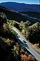
The Cherohala Skyway in early autumn.
-
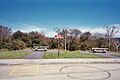
The highest point along the Skyway.
-
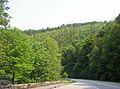
A view near the end of the Skyway in Tellico Plains.


