
Lenoir City, Tennessee facts for kids
Quick facts for kids
Lenoir City, Tennessee
|
|
|---|---|
| City of Lenoir City | |

US Route 11 passing through downtown Lenoir City, Tennessee.
|
|
| Nickname(s):
Lakeway to the Smokies
|
|

Location of Lenoir City in Loudon County, Tennessee.
|
|
| Country | United States |
| State | Tennessee |
| Counties | Loudon |
| Settled | 1810 |
| Founded | 1840 |
| Incorporated | 1907 |
| Named for | William Lenoir and William Ballard Lenoir |
| Government | |
| • Type | Mayor-council-administrator |
| Area | |
| • Total | 8.63 sq mi (22.34 km2) |
| • Land | 8.63 sq mi (22.34 km2) |
| • Water | 0.00 sq mi (0.00 km2) |
| Elevation | 856 ft (261 m) |
| Population
(2020)
|
|
| • Total | 10,117 |
| • Density | 1,172.85/sq mi (452.84/km2) |
| Time zone | UTC-5 (Eastern (EST)) |
| • Summer (DST) | UTC-4 (EDT) |
| ZIP codes |
37771-37772
|
| Area code(s) | 865 |
| FIPS code | 47-41760 |
| GNIS feature ID | 2404912 |
Lenoir City is a city in Loudon County, Tennessee. It's a suburban area, meaning it's near a larger city but has its own community feel. In 2020, about 10,117 people lived there. Lenoir City is part of the larger Knoxville metropolitan area. It sits along the Tennessee River, southwest of Knoxville.
Contents
History of Lenoir City
Early Inhabitants and Settlements
People have lived in the Lenoir City area for thousands of years. These were Native American groups. On Bussell Island, across the Tennessee River, tools and signs of life from as far back as 8000 B.C. have been found. Some historians believe this island was once "Coste," a village visited by Spanish explorer Hernando de Soto in 1540.
The Cherokee people called this area Wa'ginsi. They believed a large serpent lived there. Seeing it was thought to bring bad luck. In the early 1800s, Judge David Campbell, an early settler, built a log cabin and a gristmill here.
The Lenoir Family and Their Plantation
In the early 1800s, General William Lenoir received a large piece of land, about 5,000 acres, for his service in the American Revolutionary War. This land included what is now Lenoir City. After a court case, the land officially became his in 1809.
General Lenoir then gave the land to his oldest son, William Ballard Lenoir. In 1810, William Ballard Lenoir moved there with his wife. He started a large farm, known as a plantation. He grew crops and raised animals, including Berkshire hogs. He also built a sawmill and a flour mill. In the 1830s, he built the Lenoir Cotton Mill. This was one of the first cotton mills in the southern United States.
After William Ballard Lenoir passed away, his children took over the businesses. They formed the William Lenoir and Brothers Company. In 1855, a railroad came through the plantation. A train station was built, and a community called Lenoir Station grew around it.
Lenoir City During the Civil War
During the American Civil War, the Lenoir family supported the Confederacy. On June 20, 1863, a Union army group arrived. They were led by General William P. Sanders. They burned the train station, sawmill, and flour mill. However, they did not burn the cotton mill. This was because cotton mills were rare, and both General Sanders and the Lenoirs were Masons.
The Lenoir City Company and Planned Development
In the late 1880s, people wanted to create new towns. These towns were often built near coal mines. In 1889, two businessmen from Knoxville, Charles McClung McGhee and Edward J. Sanford, started the Lenoir City Company. They thought the Lenoir plantation was a perfect spot for a new, planned city.
The company bought the Lenoir estate in 1890. It was about 2,700 acres. They planned Lenoir City with a grid pattern. The city was divided into four sections. One section was for middle-class and wealthy families. Another was for workers. Other sections were for factories and industries. They also planned public parks and a large garden area.
A financial downturn in the early 1890s slowed things down. By 1892, only a small number of lots had been sold. But McGhee and Sanford kept working on the project. They convinced a rail car company and a knitting mill to open factories in Lenoir City. These factories employed many people.
Lenoir City in the 20th Century
The Great Depression in the 1930s brought new projects to Lenoir City. The Tennessee Valley Authority (TVA) started building Fort Loudoun Dam in 1940. This project created many jobs for local people. It also improved roads and brought electricity to the area.
In the 1950s and 1960s, new highways were built. I-75 and I-40 were constructed. These major highways cross near Lenoir City. Later, in the 1980s, U.S. Highway 321 was built through the city. This made it easier for people to reach the Great Smoky Mountains National Park.
On February 21, 1993, a strong tornado hit Lenoir City. It caused a lot of damage to downtown and other areas. The high school and middle school were badly damaged. One person died, and 55 people were hurt.
In March 1998, a historic hotel and a block of businesses were destroyed by a large fire. The fire spread quickly because the buildings shared an attic and basement. Many businesses were lost, including a barbershop, the public library, and offices. This area was later rebuilt with new buildings, including a community college and a new library.
Lenoir City in the 21st Century
In the early 2000s, Lenoir City's economy grew. Many new businesses opened along U.S. Highway 321. A new hospital, Fort Loudoun Medical Center, was also built.
Later, two big commercial projects were announced. Creekwood Park was planned near I-75. A new four-lane road was built there. A luxury apartment complex was also constructed. In 2014, more medical offices started to open in the area. From 2016 to 2017, the city built a new community center called "The Venue." A new headquarters for the Lenoir City Utilities Board was also built there.
Another development, The Market at Town Creek, was planned. It connects U.S. 321 and Harrison Road. In 2013, Town Creek Parkway, a four-lane road, was finished. In 2016, Jennifer Wampler became the first female city councilwoman. She took over her late husband's term.
Geography

The Tennessee River forms the southern border of Lenoir City. The city is also bordered by TVA's Fort Loudoun and Watts Bar areas. Several major highways pass through Lenoir City. U.S. Route 11 runs east-to-west, parallel to the river. U.S. Route 321 goes north-to-south, crossing Fort Loudon Dam.
Interstate 75 and U.S. Route 70 meet U.S. 321 in the northern part of the city. I-75 connects Lenoir City to Knoxville (about 26 miles northeast) and Chattanooga (about 91 miles southwest). U.S. 321 goes through the center of town. It leads northwest to I-40 and east to Maryville (about 20 miles). U.S. 70 runs north of the city, connecting to Farragut and Kingston. U.S. 11 also runs through the city center, leading to Farragut and Knoxville, and southwest to Loudon.
Lenoir City was originally built along U.S. 11. This older part of the city still follows a grid plan from the 1890s. In recent years, Lenoir City has grown along U.S. 321. This area has newer businesses that serve the many travelers on I-75 and I-40.
Population and People
| Historical population | |||
|---|---|---|---|
| Census | Pop. | %± | |
| 1880 | 236 | — | |
| 1910 | 3,392 | — | |
| 1920 | 4,210 | 24.1% | |
| 1930 | 4,470 | 6.2% | |
| 1940 | 4,373 | −2.2% | |
| 1950 | 5,159 | 18.0% | |
| 1960 | 4,979 | −3.5% | |
| 1970 | 5,324 | 6.9% | |
| 1980 | 5,180 | −2.7% | |
| 1990 | 6,147 | 18.7% | |
| 2000 | 6,819 | 10.9% | |
| 2010 | 8,642 | 26.7% | |
| 2020 | 10,117 | 17.1% | |
| 2022 (est.) | 11,292 | 30.7% | |
| Sources: | |||
2020 Census Information
| Race | Number | Percentage |
|---|---|---|
| White (non-Hispanic) | 7,095 | 70.13% |
| Black or African American (non-Hispanic) | 134 | 1.32% |
| Native American | 14 | 0.14% |
| Asian | 111 | 1.1% |
| Other/Mixed | 408 | 4.03% |
| Hispanic or Latino | 2,355 | 23.28% |
In 2020, Lenoir City had 10,117 people living there. There were 3,479 households and 2,198 families.
2010 Census Information
In 2010, the city had 8,642 people. There were 3,369 households and 2,183 families. About 87.3% of the people were White. About 1.6% were African American. About 0.5% were Native American. About 0.6% were Asian. About 0.3% were Pacific Islander. About 8.0% were from other races. And 1.8% were from two or more races. People of Hispanic or Latino background made up 17.5% of the population.
In 2000, about 30.4% of households had children under 18. The average household had 2.33 people. The average family had 2.95 people. The population was spread out by age. About 25.0% were under 18. About 14.6% were 65 or older. The average age was 35 years.
Education
Students in Lenoir City attend either city schools or county schools. Many students who go to county elementary and middle schools in the city later transfer to the city high school. This is because the county high schools are farther away.
Lenoir City Schools
- Lenoir City Elementary School
- Lenoir City Middle School
- Lenoir City High School
Loudon County Schools within Lenoir City
- Eaton Elementary School
- North Middle School
- Highland Park Elementary School
Climate
Lenoir City has a humid subtropical climate. This means it has warm temperatures and rain throughout the year.
| Climate data for Lenoir City, Tennessee (1991–2020 normals, extremes 1962–present) | |||||||||||||
|---|---|---|---|---|---|---|---|---|---|---|---|---|---|
| Month | Jan | Feb | Mar | Apr | May | Jun | Jul | Aug | Sep | Oct | Nov | Dec | Year |
| Record high °F (°C) | 75 (24) |
80 (27) |
85 (29) |
91 (33) |
95 (35) |
102 (39) |
106 (41) |
104 (40) |
99 (37) |
97 (36) |
85 (29) |
77 (25) |
106 (41) |
| Mean daily maximum °F (°C) | 48.6 (9.2) |
53.1 (11.7) |
62.0 (16.7) |
71.4 (21.9) |
79.0 (26.1) |
85.9 (29.9) |
89.0 (31.7) |
88.4 (31.3) |
83.5 (28.6) |
72.9 (22.7) |
61.2 (16.2) |
52.0 (11.1) |
70.6 (21.4) |
| Daily mean °F (°C) | 38.3 (3.5) |
41.9 (5.5) |
49.7 (9.8) |
58.5 (14.7) |
67.1 (19.5) |
75.0 (23.9) |
78.5 (25.8) |
77.6 (25.3) |
71.9 (22.2) |
60.3 (15.7) |
48.9 (9.4) |
41.7 (5.4) |
59.1 (15.1) |
| Mean daily minimum °F (°C) | 28.0 (−2.2) |
30.7 (−0.7) |
37.4 (3.0) |
45.5 (7.5) |
55.2 (12.9) |
64.1 (17.8) |
68.1 (20.1) |
66.8 (19.3) |
60.2 (15.7) |
47.6 (8.7) |
36.6 (2.6) |
31.3 (−0.4) |
47.6 (8.7) |
| Record low °F (°C) | −14 (−26) |
−7 (−22) |
1 (−17) |
23 (−5) |
32 (0) |
39 (4) |
50 (10) |
48 (9) |
33 (1) |
24 (−4) |
11 (−12) |
−5 (−21) |
−14 (−26) |
| Average precipitation inches (mm) | 4.99 (127) |
5.22 (133) |
5.09 (129) |
5.16 (131) |
4.29 (109) |
4.24 (108) |
5.12 (130) |
3.82 (97) |
4.25 (108) |
3.02 (77) |
4.14 (105) |
5.86 (149) |
55.20 (1,402) |
| Average snowfall inches (cm) | 1.6 (4.1) |
1.3 (3.3) |
0.6 (1.5) |
0.0 (0.0) |
0.0 (0.0) |
0.0 (0.0) |
0.0 (0.0) |
0.0 (0.0) |
0.0 (0.0) |
0.0 (0.0) |
0.1 (0.25) |
0.4 (1.0) |
4.0 (10) |
| Average precipitation days (≥ 0.01 in) | 11.2 | 10.5 | 11.4 | 10.4 | 10.6 | 11.2 | 11.1 | 9.4 | 7.8 | 7.5 | 9.0 | 11.1 | 121.2 |
| Average snowy days (≥ 0.1 in) | 0.6 | 0.6 | 0.3 | 0.0 | 0.0 | 0.0 | 0.0 | 0.0 | 0.0 | 0.0 | 0.1 | 0.1 | 1.7 |
| Source: NOAA | |||||||||||||
Notable People
- Tommy Bartlett, basketball coach
- John Bowers, author
- Tom Collins, music producer
- Claire Donahue, Olympic gold-medal swimmer
- Lee Guetterman, baseball pitcher
- Graig Nettles, baseball player
- Kenny Roberts, country musician
Images for kids
-
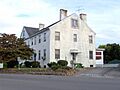
The William Ballard Lenoir House, built in 1821, now part of the Ledbetter Apartments
-
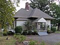
The Lenoir City Company office building, now the Lenoir City Museum, built in 1890
-
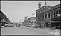
Lenoir City in 1940


See also
 In Spanish: Lenoir City para niños
