
Kingston, Tennessee facts for kids
Quick facts for kids
Kingston, Tennessee
|
|||
|---|---|---|---|

Kingston
|
|||
|
|||

Location of Kingston in Roane County, Tennessee.
|
|||
| Country | United States | ||
| State | Tennessee | ||
| County | Roane | ||
| Settled | 1792 | ||
| Incorporated | 1799 | ||
| Named for | Maj. Robert King, officer at Fort Southwest Point | ||
| Area | |||
| • Total | 8.18 sq mi (21.18 km2) | ||
| • Land | 7.29 sq mi (18.88 km2) | ||
| • Water | 0.89 sq mi (2.30 km2) | ||
| Elevation | 764 ft (233 m) | ||
| Population
(2020)
|
|||
| • Total | 5,953 | ||
| • Density | 816.60/sq mi (315.31/km2) | ||
| Time zone | UTC-5 (Eastern (EST)) | ||
| • Summer (DST) | UTC-4 (EDT) | ||
| ZIP code |
37763
|
||
| Area code(s) | 865 | ||
| FIPS code | 47-39620 | ||

Kingston is a city in Roane County, Tennessee, United States. It's the main city, also called the county seat, of Roane County. Kingston is about 36 miles southwest of Knoxville. In 2010, about 5,934 people lived there. The city is right next to Watts Bar Lake.
Contents
History of Kingston
Kingston's story began with Fort Southwest Point. This fort was built in 1792 just south of where Kingston is today. Back then, this area was at the edge of where European-Americans were allowed to settle. A Cherokee village, led by Chief Tollunteeskee, was located across the river. Today, that area is Rockwood.
In 1805, Colonel Return J. Meigs worked out of Southwest Point. He became the Cherokee Agent, which meant he was the main contact person for the Cherokee people. The city of Kingston was officially started on October 23, 1799. It was named after Major Robert King, who was an officer at Fort Southwest Point in the 1790s.
Kingston as State Capital

For one day, on September 21, 1807, Kingston was the state capital of Tennessee. The Tennessee General Assembly (the state's law-making group) met in Kingston that day. This happened because of a deal with the Cherokee people. They had been told that if they gave up the land that is now Roane County, Kingston would become the capital. After that one day, the Assembly went back to meeting in Knoxville.
Kingston During the Civil War
When the Civil War started in 1861, Kingston was chosen for an important meeting. This meeting was for the East Tennessee Convention, which wanted to create a new state in East Tennessee that would support the Union. However, soldiers from the Confederate side took over the area, so the meeting never happened.
In October 1861, William B. Carter and others planned the East Tennessee bridge burnings from Kingston. These burnings were meant to stop Confederate supplies. Later, on November 24, 1863, Confederate Cavalry soldiers tried to take Kingston from the Union army. This was called the Battle of Kingston, but the Union forces successfully defended the city.
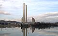
Kingston Fossil Plant
In 1955, the Tennessee Valley Authority (TVA) finished building the Kingston Fossil Plant. At that time, it was the biggest power plant in the world that burned coal. This plant uses about 14,000 tons of coal every day. It can make a lot of electricity, up to 1,456 megawatts. The plant has very tall smokestacks, about 1,000 feet (305 meters) high. You can easily see them if you drive on Interstate 40 through Roane County.
On December 22, 2008, a large area holding waste from the power plant broke open. This spill, known as the Kingston Fossil Plant coal fly ash slurry spill, released more than 1 billion gallons of waste into the nearby area.
Geography and Location
Kingston is located where three rivers meet: the Clinch, the Emory, and the Tennessee. These rivers now flow into Watts Bar Lake. This lake is a large reservoir created by the Watts Bar Dam, which is a few miles southwest of Kingston.
Roads and Transportation
Kingston is easy to reach by road. It's near where U.S. Route 70 and State Route 58 meet. U.S. Route 70 connects Kingston to Knoxville in the east and Nashville in the west. State Route 58 goes to Oak Ridge to the northeast and Chattanooga to the south. The major highway Interstate 40 also passes through Kingston, running close to U.S. 70.
Area and Water
The city of Kingston covers a total area of about 8.18 square miles (21.18 square kilometers). Most of this area, about 7.29 square miles (18.88 square kilometers), is land. The rest, about 0.89 square miles (2.30 square kilometers), is water. This means about 9.56% of the city's area is water.
Climate in Kingston
| Climate data for Kingston, Tennessee, 1991–2020 normals, extremes 2000–present | |||||||||||||
|---|---|---|---|---|---|---|---|---|---|---|---|---|---|
| Month | Jan | Feb | Mar | Apr | May | Jun | Jul | Aug | Sep | Oct | Nov | Dec | Year |
| Record high °F (°C) | 74 (23) |
81 (27) |
86 (30) |
89 (32) |
94 (34) |
104 (40) |
106 (41) |
102 (39) |
99 (37) |
95 (35) |
84 (29) |
75 (24) |
106 (41) |
| Mean maximum °F (°C) | 65.6 (18.7) |
70.4 (21.3) |
79.1 (26.2) |
85.1 (29.5) |
89.1 (31.7) |
94.4 (34.7) |
95.4 (35.2) |
94.5 (34.7) |
92.0 (33.3) |
85.1 (29.5) |
74.1 (23.4) |
67.5 (19.7) |
96.9 (36.1) |
| Mean daily maximum °F (°C) | 46.3 (7.9) |
51.2 (10.7) |
60.5 (15.8) |
70.4 (21.3) |
78.1 (25.6) |
85.0 (29.4) |
87.7 (30.9) |
87.1 (30.6) |
82.1 (27.8) |
71.6 (22.0) |
58.8 (14.9) |
49.0 (9.4) |
69.0 (20.5) |
| Daily mean °F (°C) | 37.1 (2.8) |
40.8 (4.9) |
48.9 (9.4) |
58.0 (14.4) |
66.9 (19.4) |
74.6 (23.7) |
77.8 (25.4) |
77.0 (25.0) |
71.5 (21.9) |
59.9 (15.5) |
48.1 (8.9) |
40.3 (4.6) |
58.4 (14.7) |
| Mean daily minimum °F (°C) | 27.9 (−2.3) |
30.4 (−0.9) |
37.2 (2.9) |
45.6 (7.6) |
55.7 (13.2) |
64.2 (17.9) |
68.0 (20.0) |
66.8 (19.3) |
61.0 (16.1) |
48.2 (9.0) |
37.4 (3.0) |
31.6 (−0.2) |
47.8 (8.8) |
| Mean minimum °F (°C) | 11.9 (−11.2) |
17.4 (−8.1) |
22.6 (−5.2) |
31.9 (−0.1) |
40.2 (4.6) |
54.6 (12.6) |
59.7 (15.4) |
59.5 (15.3) |
49.8 (9.9) |
33.9 (1.1) |
23.7 (−4.6) |
19.5 (−6.9) |
10.4 (−12.0) |
| Record low °F (°C) | 0 (−18) |
3 (−16) |
15 (−9) |
25 (−4) |
32 (0) |
47 (8) |
54 (12) |
53 (12) |
40 (4) |
29 (−2) |
16 (−9) |
3 (−16) |
0 (−18) |
| Average precipitation inches (mm) | 5.46 (139) |
5.95 (151) |
5.37 (136) |
5.46 (139) |
4.66 (118) |
4.72 (120) |
5.21 (132) |
3.90 (99) |
4.27 (108) |
3.22 (82) |
4.54 (115) |
6.05 (154) |
58.81 (1,493) |
| Average snowfall inches (cm) | 1.1 (2.8) |
0.6 (1.5) |
0.0 (0.0) |
0.0 (0.0) |
0.0 (0.0) |
0.0 (0.0) |
0.0 (0.0) |
0.0 (0.0) |
0.0 (0.0) |
0.0 (0.0) |
0.0 (0.0) |
0.1 (0.25) |
1.8 (4.55) |
| Average precipitation days (≥ 0.01 in) | 10.1 | 10.2 | 10.7 | 9.9 | 9.8 | 11.3 | 11.0 | 8.8 | 7.3 | 7.4 | 8.5 | 10.4 | 115.4 |
| Average snowy days (≥ 0.1 in) | 0.5 | 0.3 | 0.0 | 0.0 | 0.0 | 0.0 | 0.0 | 0.0 | 0.0 | 0.0 | 0.1 | 0.1 | 1.0 |
| Source 1: NOAA | |||||||||||||
| Source 2: National Weather Service (mean maxima/minima 2006–2020) | |||||||||||||
Population of Kingston
| Historical population | |||
|---|---|---|---|
| Census | Pop. | %± | |
| 1850 | 386 | — | |
| 1860 | 307 | −20.5% | |
| 1870 | 739 | 140.7% | |
| 1880 | 858 | 16.1% | |
| 1900 | 548 | — | |
| 1910 | 824 | 50.4% | |
| 1920 | 516 | −37.4% | |
| 1930 | 827 | 60.3% | |
| 1940 | 880 | 6.4% | |
| 1950 | 1,627 | 84.9% | |
| 1960 | 2,010 | 23.5% | |
| 1970 | 4,142 | 106.1% | |
| 1980 | 4,441 | 7.2% | |
| 1990 | 4,552 | 2.5% | |
| 2000 | 5,264 | 15.6% | |
| 2010 | 5,934 | 12.7% | |
| 2020 | 5,953 | 0.3% | |
| Sources: | |||
2020 Census Information
In the 2020 United States census, there were 5,953 people living in Kingston. These people made up 2,225 households. Out of these households, 1,335 were families.
| Race | Number | Percentage |
|---|---|---|
| White (non-Hispanic) | 5,309 | 89.18% |
| Black or African American (non-Hispanic) | 203 | 3.41% |
| Native American | 9 | 0.15% |
| Asian | 56 | 0.94% |
| Pacific Islander | 2 | 0.03% |
| Other/Mixed | 242 | 4.07% |
| Hispanic or Latino | 132 | 2.22% |
Local Newspapers
You can read local news in the Roane County News.
Famous People from Kingston
- Robert K. Byrd (1823–1885), a Union Army colonel and state senator.
- George Lewis Gillespie, Jr. (1841–1913), a U.S. Army general who received the Medal of Honor.
- Jennie Jackson (1852–1910), one of the first members of the Fisk Jubilee Singers.
- Martin W. Littleton (1872–1934), a U.S. congressman and lawyer.
- Sam Rayburn (1882–1961), a U.S. congressman and Speaker of the House.
- Bowden Wyatt (1917–1969), a football coach at the University of Tennessee.
- Wil Crowe Professional baseball player for the Pittsburgh Pirates.
Images for kids
-
The Kingston power plant

See also
 In Spanish: Kingston (Tennessee) para niños
