Farragut, Tennessee facts for kids
Quick facts for kids
Farragut
|
|||
|---|---|---|---|

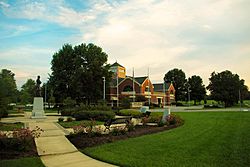
Farragut Town Hall and Folklife Museum
|
|||
|
|||

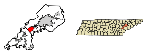
Location of Farragut in Knox County, Tennessee.
|
|||
| Country | United States | ||
| State | Tennessee | ||
| Counties | Knox, Loudon | ||
| Settled | 1787 | ||
| Incorporated | 1980 | ||
| Named for | David Farragut | ||
| Government | |||
| • Type | Mayor-council | ||
| Area | |||
| • Total | 16.14 sq mi (41.80 km2) | ||
| • Land | 15.98 sq mi (41.38 km2) | ||
| • Water | 0.16 sq mi (0.42 km2) | ||
| Elevation | 958 ft (292 m) | ||
| Population
(2020)
|
|||
| • Total | 23,506 | ||
| • Density | 1,471.15/sq mi (568.01/km2) | ||
| Time zone | UTC-5 (Eastern (EST)) | ||
| • Summer (DST) | UTC-4 (EDT) | ||
| ZIP code |
37922 and 37934
|
||
| Area code(s) | 865 | ||
| FIPS code | 47-25760 | ||
| GNIS feature ID | 2406494 | ||
Farragut is a suburban town in Tennessee, United States. It is located in Knox and Loudon counties. In 2020, about 23,506 people lived there. Farragut is part of the larger Knoxville Metropolitan Area. The town is named after David Farragut. He was a famous Union Admiral during the American Civil War. He was born near Farragut in 1801.
Contents
History of Farragut
The area was first known as Campbell's Station. This name came from a fort and a stagecoach stop built by Captain David Campbell in 1787. The old brick Campbell's Station Inn was built in 1810. It still stands today on Kingston Pike, close to the Farragut Town Hall. A battle during the American Civil War happened here on November 16, 1863. It was called the Battle of Campbell's Station.
The historic village of Concord was founded in 1854. It is just east of Farragut's current border. Concord is on the main railway line to Atlanta. It is also on the main channel of the Tennessee River. In the late 1800s, Concord was an important place for moving Tennessee marble. Many old buildings, historic homes, and churches are still there along the river.
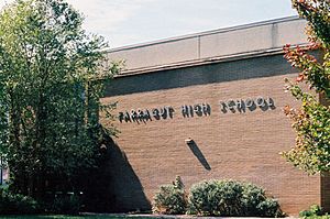
The first Farragut High School was built by the community in 1904. It moved to its current spot in 1976. Some parts of Farragut are in the school zone for Hardin Valley Academy. This school was built in 2008 in the nearby area of Hardin Valley.
In 1979, the city of Knoxville tried to expand its borders into the Farragut area. This made the people living in Farragut want to become their own town. On January 16, 1980, Farragut voted to become an official town. This stopped Knoxville from taking over their community. A group called the Farragut Community Group led this effort. The first mayor, Bob Leonard, was elected on April 1, 1980. He served with four other elected officials called aldermen.
Geography of Farragut
Farragut covers about 16.2 square miles (42.1 km2). Most of this area, 16.1 square miles (41.7 km2), is land. Only a small part, 0.2 square miles (0.4 km2), is water.
The town of Farragut has clear boundaries. To the north, it is mostly bordered by I-40/I-75. To the south, it is bordered by Turkey Creek Road and a railroad line. The western border is the Loudon County line. To the east, it is bordered by Lovell Road and the Concord Hills neighborhoods.
Farragut is in a hilly area. It lies between Blackoak Ridge to the north and the Tennessee River (which forms Fort Loudoun Lake) to the south. Kingston Pike runs through the town. This road is a combination of U.S. Route 70 and U.S. Route 11. The community of Concord is just southeast of Farragut. Hardin Valley is to the north, across Blackoak Ridge.
Population Information
| Historical population | |||
|---|---|---|---|
| Census | Pop. | %± | |
| 1990 | 12,793 | — | |
| 2000 | 17,720 | 38.5% | |
| 2010 | 20,676 | 16.7% | |
| 2020 | 23,506 | 13.7% | |
| 2023 (est.) | 25,579 | 23.7% | |
| Sources: | |||
2020 Census Details
| Race | Number | Percentage |
|---|---|---|
| White (non-Hispanic) | 19,720 | 83.89% |
| Black or African American (non-Hispanic) | 431 | 1.83% |
| Native American | 30 | 0.13% |
| Asian | 1,661 | 7.07% |
| Pacific Islander | 8 | 0.03% |
| Other/Mixed | 869 | 3.7% |
| Hispanic or Latino | 787 | 3.35% |
In 2020, the United States census showed that 23,506 people lived in Farragut. There were 8,657 households, which are groups of people living together. Also, there were 6,744 families living in the town.
Historic Places
- Avery Russell House
Schools in Farragut
The schools in Farragut are part of the Knox County Schools system.
Elementary schools for Farragut students are:
- Farragut Primary School (for grades Kindergarten to 2nd grade)
- Farragut Intermediate School (for grades 3rd to 5th grade)
Most students in Farragut attend these schools for older grades:
- Farragut Middle School (for grades 6th to 8th grade)
- Farragut High School (for grades 9th to 12th grade)
Some parts of Farragut, especially north of Interstate 75, are zoned for other schools. These include Hardin Valley Middle School (grades 6-8) and Hardin Valley Academy (grades 9-12).
There are also two private schools in the area:
- Knoxville Christian School
- Concord Christian School
Famous People from Farragut
Many notable people have connections to Farragut, including:
- Bill Bates, a former NFL football player and coach
- Tyson Clabo, a former NFL football player
- Nicky Delmonico, a former Major League Baseball player
- David Farragut, a famous Civil War (Union) admiral
- Robert Ben Garant, an actor, comedian, writer, director, and producer
- Michael McKenry, a former Major League Baseball player
- Tim Priest, an attorney and sports commentator
- Archibald Roane, the second Governor of Tennessee
- Nick Senzel, a current Major League Baseball player
- Jerry Sisk Jr., who helped start Jewelry Television
- Kyle Waldrop, a former Major League Baseball player
Local Media
- WFIV-FM (a radio station)
- Farragut Press [1] (a local newspaper)
- Farragut Life Magazine (a local magazine)
See also
 In Spanish: Farragut (Tennessee) para niños
 | George Robert Carruthers |
 | Patricia Bath |
 | Jan Ernst Matzeliger |
 | Alexander Miles |


