Kingston Pike facts for kids
Quick facts for kids |
|
|
Kingston Pike Historic District
|
|
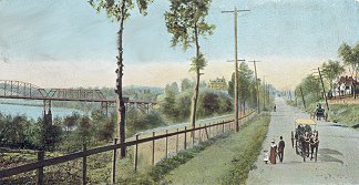
Kingston Pike, circa 1900
|
|
| Location | Roughly 2728–3151, 3201, 3219, 3401, 3425, and 3643 Kingston Pike Knoxville, Tennessee |
|---|---|
| Area | approximately 61 acres (25 ha) |
| Built | 1834–1930 |
| Architect | multiple |
| Architectural style | Federal, Tudor Revival, Spanish Colonial Revival, Neoclassical |
| NRHP reference No. | 96001404 |
| Added to NRHP | December 4, 1996 |
Kingston Pike is a major road in Knox County, Tennessee, United States. It connects Downtown Knoxville with West Knoxville, Farragut, and other towns nearby. This road is part of two important U.S. highways, Route 11 and Route 70.
From the 1790s until the 1960s, Kingston Pike was the main road in western Knox County. It was also a key part of several cross-country highways. Today, it is a huge shopping area with hundreds of stores, restaurants, and other businesses.
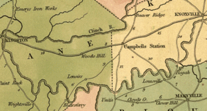
The original Kingston road was first mapped in 1792 by Charles McClung. It linked Knoxville to Campbell's Station, which is now Farragut. Around 1795, the road was extended to Fort Southwest Point in what is now Kingston. During the Civil War, both Confederate and Union soldiers fought battles along this road. They were trying to control Knoxville.
In 1866, the Kingston Turnpike Company was formed to make the road better. By 1893, the improved road reached the county line. From the 1920s to the 1950s, Kingston Pike was a popular stop for tourists. They traveled along the Dixie and Lee highways, which met at Kingston Pike.
After West Town Mall opened in 1970, Kingston Pike became Knoxville's biggest shopping area. Historian Jack Neely once said, "If suburban sprawl had a local name, it would be Kingston Pike." Today, the road has a large shopping mall, many smaller shopping centers, and over 100 chain restaurants. It also has more parking lot space than any other street in the Knoxville area.
Contents
What is Kingston Pike Like?
Kingston Pike is a five-lane road that stretches for about 20 miles (32 km) (32 kilometers). It starts near the L&N train tracks east of Alcoa Highway. It ends where US 70 and US 11 split in Dixie Lee Junction. This spot is right on the border of Knox and Loudon counties.
East of the train tracks, Kingston Pike becomes Cumberland Avenue. This road goes into the Fort Sanders neighborhood and downtown Knoxville. Further west, US 70 continues to Kingston, and US 11 goes southwest to Lenoir City.
The westernmost address on Kingston Pike is the old Court Cafe building (13110). The easternmost is the Metron Corporation (2309). The short section between the county line and the US 70/US 11 split is usually called Kingston Pike. However, businesses there might have "Highway 11 East" addresses.
Before big highway projects in the 1960s, Kingston Pike had more twists and turns past Bearden. You can still see this from the many side roads named "Old Kingston Pike." Kingston Pike is also part of State Route 1 (SR 1). It runs almost parallel to Interstate 40 (I-40) and I-75. These interstates are just north of Kingston Pike.
Kingston Pike connects many communities. These include Knoxville, Farragut, Sequoyah Hills, West Hills, Bearden, Ebenezer Mill, and Concord.
Kingston Pike's Past
Early Days of the Road
What we call Kingston Pike today was once a trail used by Native Americans. This trail went west from Knoxville to Sinking Creek. From there, it turned south and passed through the modern Concord area. It then crossed the Tennessee River to reach the Overhill Cherokee towns in the Little Tennessee Valley.
By 1788, this trail became part of the North Carolina Road. This was the main route connecting settlements in East Tennessee with those near Nashville. In 1792, Knox County asked Charles McClung to build a public road. McClung had mapped Knoxville the year before. The new road went from Knoxville to Campbell's Station (now Farragut). This road was about 30 feet (9.1 m) (9 meters) wide. By 1800, it was extended to Kingston. Later, it was made even wider, to 50 feet (15.24 meters).
For many years, the Kingston road was a dangerous place. In 1792, the home of Ebenezer Byram was attacked by Creeks. The next year, a small Cherokee group attacked Cavet's Station, killing most of its people. In the early 1800s, highwaymen robbed travelers on the road. By 1820, a part of the road west of Bearden was even called "Murderers' Hollow." From about 1810 to 1850, a stagecoach line called the "Great Western Line" ran on the Kingston road. It connected Knoxville and Nashville.
Kingston Pike During the Civil War
In November 1863, Confederate soldiers led by General James Longstreet marched north. They hoped to take Knoxville from Union forces under Ambrose Burnside. Burnside's troops had taken the city in September. Longstreet wanted to attack from the south. But because of strong defenses in South Knoxville, he had to cross the Tennessee River at Huff's Ferry in Loudon. Then he marched on Knoxville from the west.
Burnside's troops tried to slow Longstreet down. This gave them time to make Knoxville's defenses stronger. On November 16, some of Burnside's troops fought Longstreet's lead group at the Battle of Campbell's Station. This battle lasted about six hours. It allowed most of Burnside's forces to get back to Knoxville.
As Burnside's engineer Orlando Poe worked hard to fortify the city, Union cavalry commander William P. Sanders fought another delaying battle. This happened just west of town near the Bleak House. Sanders bought Poe another 36 hours before he was badly wounded.
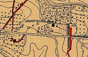
With Knoxville fortified, Longstreet surrounded the city for a siege. He set up his headquarters at the Bleak House. On November 29, after two weeks, Longstreet ordered an attack on Fort Sanders. This fort was a strong earth wall overlooking Kingston road. But the attack failed, and Longstreet left a few days later.
The Kingston Turnpike
In May 1866, the Kingston Turnpike Company was created. Its goal was to improve the Kingston road to the Knox County line. The next year, Professor R. L. Kirkpatrick re-surveyed the first five miles of the road. Then, a crew led by Colonel R. F. Bibb built a new macadamized surface. The new road was also raised, and ditches were added to help with drainage.
Knox County bought the Kingston Turnpike Company in 1892. By late 1893, they finished improving the road to the county line. By 1913, trolley tracks were built along Kingston Pike. This led to more homes and apartment buildings being built along the road. In the early 1920s, Kingston Pike was paved with a hard surface. This was because more people were using cars. By the end of World War II, Kingston Pike had become a four-lane road.
The Dixie Lee Highway Era
From the 1920s to the late 1950s, Kingston Pike was known as the "Dixie Lee Highway." This was because it was part of two cross-country auto-tourism routes. These were the Dixie Highway (US 70) and the Lee Highway (US 11). The Dixie Highway was a north-south route. It connected cities in the Midwestern United States with beaches in the South. The Lee Highway was mostly an east-west route. It connected Arlington, Virginia, with California.
The two routes met in downtown Knoxville. They split at the US 70/US 11 junction at the Knox-Loudon county line. This junction became known as the Dixie-Lee Junction.
All the cars traveling on the Dixie and Lee highways brought a tourism boom to Kingston Pike. Starting in the 1920s, businesses for travelers appeared along the road. These included "tourist camps," which were like early motels. Knoxville's first motel, Edd's Tourist Camp, opened in Bearden in the late 1920s.
Restaurants also started to appear. Many had bright signs and cool, modern designs. They had fun names like the "White Dot Barbecue Stand" and the "Wonder Lunch Room." Drive-in theaters and skating rinks also opened along Kingston Pike in the 1950s.
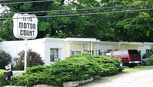
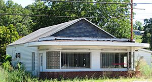
The building of the Interstate Highway System in the 1950s and 1960s changed things. Interstate 40 (I-40) and I-75 run near Kingston Pike. They took away most of the long-distance traffic. Because of this, most of Kingston Pike's tourism businesses closed. Only a few buildings from this time are still around today. These include the 11-70 Motor Court near Farragut and the old Court Cafe building.
Kingston Pike's Modern Growth
When cars became popular in the 1920s, many wealthy Knoxville residents moved to suburbs. One of the first was Sequoyah Hills, built near Kingston Pike in the 1920s. After World War II, Kingston Pike saw a huge increase in suburban growth. New neighborhoods like West Hills caused the population in the Kingston Pike area to grow by 38% in the 1950s.
In 1961, Knoxville added a large area along Kingston Pike to the city. This brought several small towns into Knoxville. When West Town Mall opened in the 1970s, many stores in downtown Knoxville closed. Kingston Pike then became Knoxville's main shopping area.
Kingston Pike Historic District
The Kingston Pike Historic District includes two dozen houses and apartment buildings. These were added to the National Register of Historic Places in 1996. The houses are mostly on the 2000 and 3000 blocks of the road. They were built between 1834 and 1930. This means they show what the road was like before it became full of strip malls and stores.
The buildings in the district show many different architectural styles. These include Federal, Georgian Revival, Bungalow, Tudor Revival, Queen Anne, Neoclassical Revival, and Spanish Colonial Revival.
Some buildings on Kingston Pike are listed on the National Register by themselves. They are not part of the historic district. These include the Ossoli Circle Clubhouse (2511) and the Benjamin Morton House (4084). The Baker Peters House (9000) was built before the Civil War. However, it cannot be listed because it has been changed many times. Other listed places are just off Kingston Pike. These range from the 1806 Statesview in Ebenezer to the 1954 Hotpoint Living-Conditioned Home in West Hills.
Important Houses in the District
- Crescent Bend (2728): Also known as the Armstrong-Lockett House. This brick house was built in 1834 by Drury Paine Armstrong. It is in the Federal style.
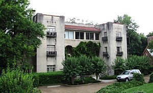
- Van Dyke Apartments (2742): A two-story brick apartment building built in 1927. It is in the Spanish Colonial Revival style.
- 3024 Kingston Pike: A two-story brick house built in 1930. It is in the Georgian Revival style.
- Monday Apartments (3039): A two-story brick apartment building built around 1928. It is in the Spanish Colonial Revival style.
- The Nicholas (3051–3065): A three-story apartment building built around 1930. It is in the Spanish Colonial Revival style.
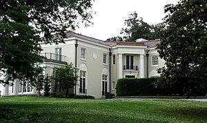
- H. L. Dulin House (3100): Also called Crescent Bluff. This two-story house was built in 1915. It was designed by architect John Russell Pope in the Neoclassical style. From 1961 to 1987, this house was home to the Dulin Art Gallery. This gallery later became the Knoxville Museum of Art. The Dulin House was listed on the Register by itself in 1974.
- George Taylor House (3128): A two-story house built in 1900. It was remodeled in 1929 by Charles I. Barber. It combines Queen Anne and Neoclassical styles.
- Bleak House (3148): Also called Confederate Memorial Hall. This two-story house was built in 1856 by Robert H. Armstrong. It was remodeled in 1930. It is in the Italianate style. This house was listed on the Register by itself in 1984.
- Westwood (3425): A two-story house built in 1890 by John E. Lutz and Adelia Armstrong Lutz. It was designed by the Baumann Brothers. It combines Queen Anne and Richardsonian Romanesque styles. This house was listed on the Register by itself in 1984.
 | Anna J. Cooper |
 | Mary McLeod Bethune |
 | Lillie Mae Bradford |


