Dixie Lee Junction, Tennessee facts for kids
Quick facts for kids
Dixie Lee Junction, Tennessee
|
|
|---|---|
| Dixie Lee Junction | |

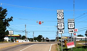
The intersection of US 70 and US 11 at Dixie Lee Junction
|
|
| Country | United States |
| State | Tennessee |
| County | Loudon |
| Elevation | 988 ft (301 m) |
| Time zone | UTC-5 (Eastern (EST)) |
| • Summer (DST) | UTC-4 (EDT) |
| ZIP code |
37772
|
| Area code(s) | 865 |
| GNIS feature ID | 1282515 |
Dixie Lee Junction is a small community in Loudon County, Tennessee. It is an unincorporated community, which means it doesn't have its own local government like a city or town. This place is special because it's where two very old and important highways, U.S. Route 70 and U.S. Route 11, meet.
The community got its name from these two historic roads. The eastern part of the Dixie Highway followed US 70, and the Lee Highway followed US 11. From the late 1920s until the 1960s, these highways were major routes for people traveling across the country by car. Dixie Lee Junction became a popular stop for tourists heading south from Knoxville. Even though new interstates now carry most of the long-distance traffic, the intersection of US 70 and US 11 is still important. It marks the western end of Kingston Pike, a busy road in western Knox County.
Where is Dixie Lee Junction?
Dixie Lee Junction is right next to the town of Farragut. The line between Knox and Loudon counties is the official border between the two communities. US 70 comes into Dixie Lee Junction from Kingston in the west. US 11 arrives from Lenoir City to the southwest.
Once they meet, these two highways continue together for about 20 miles (32 km). They pass through Farragut and then into Knoxville. Two major interstate highways, Interstate 40 (I-40) and I-75, join up just northwest of Dixie Lee Junction.
A Crossroads of History
The Dixie Highway was planned in 1914. Its goal was to create an easy route from the Midwestern United States all the way to Florida. The eastern part of this highway went through downtown Knoxville. It then turned west along Cumberland Avenue and continued into West Knoxville on Kingston Pike.
The Lee Highway was another important road. It connected New York in the east to San Francisco in the west. This highway entered Knoxville from Bean Station to the northeast. It then joined up with the Dixie Highway in downtown Knoxville.
A Stop for Travelers
Knoxville was located about halfway between the Midwest and Florida on the Dixie Highway. This made it a perfect place for tourists heading to Florida to stop for the night. During the 1930s, 1940s, and 1950s, Kingston Pike was full of places for travelers to stay. There were many motor courts and motels. Restaurants with unique buildings and bright signs tried to get the attention of drivers passing by.
Businesses in Dixie Lee Junction during this time were often "last-chance" stops. They offered food, gas, and other supplies. Drivers knew this was their last chance to get what they needed before entering a mostly rural area on their way to Chattanooga.
Arts and Culture
The band Elf released a song called "Dixie Lee Junction." The song is about this community. It was on their 1972 album, Elf. The lead singer of Elf was Ronnie James Dio, who later became a very famous rock musician.
 | Bayard Rustin |
 | Jeannette Carter |
 | Jeremiah A. Brown |


