Fort Sanders, Knoxville facts for kids
Quick facts for kids |
|
|
Fort Sanders Historic District
|
|
 |
|
| Location | Roughly bounded by White and Grand Aves. and 11th and 19th Sts. Knoxville, Tennessee |
|---|---|
| Area | approximately 105 acres (42 ha) |
| Built | 1880–1930 |
| Architect | multiple |
| Architectural style | Queen Anne, Bungalow/Craftsman, Georgian Revival, Italianate |
| NRHP reference No. | 80003839 |
| Added to NRHP | September 16, 1980 |
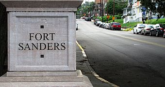
Fort Sanders is a neighborhood in Knoxville, Tennessee, USA. It is located just west of downtown and right next to the main campus of the University of Tennessee. This area was first built in the late 1800s for families with good incomes. Today, it mainly provides homes for university students.
The neighborhood still has many of its original Victorian-style houses and buildings. Hundreds of these were added to the National Register of Historic Places in 1980. This makes the area known as the Fort Sanders Historic District.
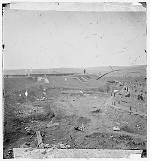
Fort Sanders gets its name from a Civil War-era fort. This fort was a Union stronghold that once stood near the center of the neighborhood. It was the site of an important battle in 1863. Before Union soldiers took over Knoxville, Confederate troops often called it "Fort Loudon."
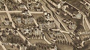
In the 1880s, some of Knoxville's richer residents built large houses in the southern part of Fort Sanders. This area was then called "White's Addition." The northern part, "Ramsey's Addition," was built for factory managers and workers. Fort Sanders became its own city called West Knoxville in 1888. It later joined Knoxville in 1897. In its early days, important people like factory owners, politicians, and university professors lived here.
Fort Sanders was also the childhood home of author James Agee. His famous book, A Death in the Family, which won a Pulitzer Prize, is set in this neighborhood. After World War II, the University of Tennessee grew a lot. This led to many old homes in Fort Sanders being turned into apartments for students.
Contents
Exploring Fort Sanders: Location and Surroundings
Fort Sanders and the University of Tennessee campus are on a hill. This hill is bordered by Second Creek to the east and Third Creek to the west. The Tennessee River is to the south. To the north, there's a dip in the land where the Southern Railway tracks and Interstate 40 are now.
The university is on the southern half of the hill, looking over the river. Fort Sanders is on the northern half. Cumberland Avenue, also called "The Strip," is the rough boundary between the two. Fort Sanders Regional Medical Center is in the western part of the Fort Sanders neighborhood.
The World's Fair Park, where the 1982 World's Fair was held, is across Second Creek to the east. The Mechanicsville neighborhood is north of I-40. West of the L&N tracks, Cumberland Avenue turns into Kingston Pike. This road continues into what is now called West Knoxville.
A Look Back: Fort Sanders History
The Battle of Fort Sanders: A Key Civil War Moment
In November 1863, Confederate soldiers, led by General James Longstreet, marched towards Knoxville. They hoped to remove Union forces, led by Ambrose Burnside, who had taken over Knoxville a few months earlier. After a small fight at Campbell's Station (Farragut), Longstreet's troops came closer to Knoxville from the west.
Union General William P. Sanders slowed down the Confederates. This gave Union forces in the city time to finish building their defenses. Sadly, General Sanders was badly wounded on November 18 and died the next day. With the Union defenses ready, Longstreet decided to surround the city and try to starve the Union soldiers out. This was called the Siege of Knoxville.
During the siege, Confederate guards were positioned along what is now Twenty-First Street. Union defenses included Fort Byington and Battery Noble. Fort Sanders, originally called "Fort Loudon," was an earthen fort. It was renamed in honor of General Sanders by the Union troops.
On the morning of November 29, 1863, after two weeks of siege, Longstreet ordered an attack on Fort Sanders. He hoped to break through the Union lines. The attack lasted only twenty minutes. The Confederate soldiers could not get past a deep trench at the base of the fort. They had to retreat with many casualties. This battle ended Longstreet's chances of taking the city, and he soon retreated.
How Fort Sanders Grew: Early Development
Knoxville grew quickly after the Civil War because of new industries. In the 1880s, pollution from a metal factory made people in the fancy Summit Hill area look for new homes. Many chose the hillslope west of Second Creek, known as White's Addition. This area was named after Hugh Lawson White, who once owned a house there. Wealthy residents like candy maker Martin Luther Ross built large homes here.
At the same time, many factories appeared along Second Creek. The area called Ramsey's Addition grew to house factory managers and workers. Unlike White's Addition, Ramsey's Addition had a mix of people and homes. These ranged from grand Victorian mansions to smaller shotgun-style houses.
An 1886 map of Knoxville shows that the Fort Sanders area had grown as far west as what is now Seventeenth Street. The University of Tennessee had several buildings around "The Hill." Factories along Second Creek included the Knoxville Tannery and the Knoxville Iron Company.
Because of the need for city services, the Fort Sanders area became its own city called West Knoxville on March 8, 1888. Its population was 1,520. West Knoxville joined Knoxville in 1897. Today, "West Knoxville" usually means the part of Knoxville along Kingston Pike, west of Third Creek.
Fort Sanders: Later Development and Changes
In the late 1800s and early 1900s, many important people in Knoxville's industries lived in Fort Sanders. Max Arnstein, who owned a large department store, had houses on Laurel Avenue. Matthew McClung, a wealthy wholesaler, built a house on Clinch Avenue. John J. Craig, a marble quarry owner, lived on Highland. Coca-Cola bottler J. Patrick Roddy lived on Clinch. Even William Rule, who started the Knoxville Journal newspaper, lived here.
Fort Sanders was also home to many early University of Tennessee professors and leaders. Weston Fulton, who invented the sylphon (used in thermostats), lived on Clinch Avenue. William Waller Carson, who started the school's civil engineering department, lived on Clinch. Artist Catherine Wiley lived on White Avenue while teaching at UT.
When cars became popular in the 1920s, wealthier Knoxville residents started moving to suburbs outside the city. Neighborhoods like Fort Sanders began to change. After World War II, the University of Tennessee's student body grew hugely. Because of this, most homes in Fort Sanders were turned into student housing. The university's growth, and later the expansion of Fort Sanders Regional Medical Center, led to many old houses being torn down. Groups like the Fort Sanders Community Improvement Association worked hard to protect the neighborhood's history.
A Death in the Family: James Agee's Fort Sanders
Author James Agee (1909–1955) spent his early childhood in the Fort Sanders neighborhood. His family first lived on Highland Avenue. After his father's death in 1915, they moved to Laurel Avenue. Agee's grandparents lived on Clinch Avenue.
The Fort Sanders neighborhood is the main setting for Agee's famous book, A Death in the Family. The story begins with Agee and his father walking through downtown Knoxville. They visit places like Gay Street and Market Square. They pass the Deaf and Dumb Asylum and the L&N Station on their way back to Fort Sanders. Agee wrote about a vacant lot where he and his father liked to look at the lights of North Knoxville and listen to the train engines. The book ends with Agee and his uncle standing over the remains of the Civil War-era Fort Sanders.
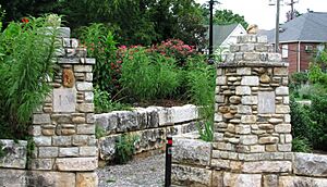
In 1999, Fifteenth Street was renamed "James Agee Street." In 2005, James Agee Park was created in a vacant lot at the corner of James Agee Street and Laurel Avenue.
Fort Sanders Today: A Lively Student Hub
Fort Sanders, often called "The Fort" by those who live there, is still a very popular place for students. Most residents are young adults. During the summer, many students go home, making the neighborhood quieter. But during the school year, it's very active and lively. Because of its young population and closeness to the university, the neighborhood is known for its social gatherings. Residents have been known to host large block parties that can attract many people. For example, on October 15, 2022, a huge celebration happened when the Tennessee Volunteers football team beat Alabama after a long losing streak.
Cumberland Avenue, or "The Strip," is a popular spot for students. It has many restaurants and stores.
During the Fall football season, Fort Sanders and the university campus become a central place for Tennessee Volunteers fans. People gather here for tailgating and pre-game activities.
The Knoxville Police Department and the University of Tennessee's Police Department work together to patrol Fort Sanders. The university's police force helps keep students safe both on campus and in the Fort Sanders area.
Fort Sanders Historic District: Preserving the Past
The Fort Sanders Historic District was added to the National Register of Historic Places in 1980. It originally included about 400 buildings. The district covers about 105 acres. Most of the houses were built between 1880 and 1930. Many are in the Victorian style (especially Queen Anne) or Bungalow/Craftsman styles. The district also has three churches and several commercial buildings.
Important Buildings in the Historic District
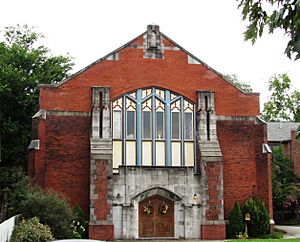
- Christ Chapel (1538 Highland Avenue): This church was built in 1895. It was first called Ramsey Methodist Church, then Epworth Methodist Church. It was partly damaged by fire and rebuilt in 1929. Christ Chapel bought and restored it in the early 1980s.
- Laurel Theater (1538 Laurel Avenue): This is a two-story brick church built in 1898. It was originally the Fort Sanders Presbyterian Church.
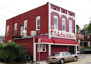
- 310 Thirteenth Street (Firedog Pizza/Deli): This is a Victorian commercial building from the late 1800s.
- 307 18th Street (18th Street IGA): This store was built around 1923. It was first known as the W.T. Roberts Grocery Store.
- 1202 Clinch Avenue: This two-story house was built in 1876, making it one of the oldest in Fort Sanders. Inventor Weston Miller Fulton once lived here.
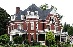
- Laurel Terrace (1415 Laurel Avenue): This is a 2½-story Queen Anne-style brick house. Candy maker Martin Luther Ross built it in 1894.
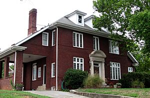
- 1604 Clinch Avenue: This two-story Georgian Revival house was built in 1914. Publisher and mayor William Rule lived here. Today, it is used by the Church of Jesus Christ of Latter-day Saints.
- Pickle Mansion (1633 Clinch): This Queen Anne-style house was built in 1889. It has a large porch that wraps around the house.
- 1705 Clinch Avenue: This 2½-story brick apartment building was built in 1903 by university professor William Waller Carson. The Ronald McDonald House bought it in 1985.
- 1803 Clinch Avenue: This 2½-story Georgian Revival-style house was built in 1912. J. Patrick Roddy, who started the Roddy Coca-Cola Bottling Company, lived here.
- 1308 White Avenue: This Queen Anne-style house was built in 1894 for marble company executive James E. Ross. It was later home to judge Charles Hayes Brown. The University of Tennessee has plans to buy and tear down this house, along with two others nearby, to build a new science facility.
 | James Van Der Zee |
 | Alma Thomas |
 | Ellis Wilson |
 | Margaret Taylor-Burroughs |


